(5.0; 1330.9 total, 843.1 to go; -10.0 from pace, -109.1 overall)
After this brief interlude with family, it’s time to get moving again. Mom makes some effort to get me to not hike for another day, but I’m somewhat leery of taking two zeroes as I’ve never done so before, and I dig in my heels. I’m back on the trail shortly after 11:00.
It’s only five miles to the first shelter, and strangely I complete them at a three-miles-an-hour pace despite it not being the afternoon, eating a Granny Smith apple as I hike. Mm, delicious absurdly heavy foods…. I arrive at the shelter to unexpectedly find someone there — Smoothie again! He’s now hiking for a few days with a girl he met at a yoga class in Delaware Water Gap. I stop to eat and lighten my pack, pulling out a loaf of raisin bread to attack. Between the weighty pack and another southbounder I’m not in much of a rush to get moving again; when the Honeymooners walk up, my plans to hike further today vanish. Four southbounders all in one place — it’s been ages since this has happened to me.
But wait, there’s more! In walks a hiker with her father, and she looks familiar — turns out it’s Kat, whom I met at Wintturi Shelter back in Vermont. I’d thought she was a northbounder, but it seems she’s really flip-flopping around Waynesboro, hiking south for a few days with her father before he heads back to work. So, all total we have five different thru-hikers here for the night, four of them true southbounders — crazy…
The rest of the day is pretty lackadaisical. The only memorable bit occurs while I’m making dinner, something Knorr-ish as usual. Smoothie’s hiking companion, a vegetarian, looks aghast at the amount of sodium in my overall meal; she calculates somewhere around 2000mg total. I take a look and see she’s wrong — one of my food items is actually two servings, not one. Mm, sodium…
September 13
(15.8; 1346.7 total, 827.3 to go; +0.8 from pace, -108.3 overall)
Today’s goal is a shelter about twenty miles south, but my hiking pace just isn’t feeling up to it,. It’s starting to get pretty dry, and water is somewhat scarce. I hike south in the latter half of the mob moving south: Honeymooners in front, Smoothie and girlfriend next, me, then Kat and her dad, in rough order. I last see Kat maybe a dozen miles into the day when I stop briefly at a road crossing to eat an apple; I assume they’re heading to the next shelter a few miles south, but after I leave it sounds like they made a very abrupt decision to spend the night in town; combined with my pace this is therefore the last time I see them.
The morning's view
I travel the next several miles to Maupin Field Shelter, arriving maybe around 17:00. I plan to only briefly stop to fill up on water, but a certain lack of energy, plus the meagerness of the water source, mean it makes more sense for me to stop for the night here. The shelter is initially occupied by someone who’s set up his tent in it; I don’t mind this when a shelter’s empty enough, but it’s not here. Eventually enough people show up that I manage to argue the owner into moving into a perfectly serviceable campsite instead. Besides Smoothie and companion there are a couple random backpackers and one flip-flopper named Toad. Toad’s from Pennsylvania somewhere around Pine Grove Furnace State Park, and he started near there June 7, hiked north, then flipped back to hike south again. He carries a rather large Jetboil stove with him as a luxury item. The Honeymooners are characteristically efficient in their hiking and thus end up at Harpers Creek Shelter about five miles south, rather than this one. (They later express surprise I didn’t make it there; I do tend to be a bit erratic in my pace at times.)
Even later yet, however, another backpacker arrives, and from our (Smoothie, Toad, me) first sight of him alone it’s clear he’s a very special hiker. He’s lean and thin, he’s hiking quickly with poles pumping, and his backpack — if you can call it that — isn’t much more than Camelbak-sized. (He tells us his base weight — what he always carries, then additionally supplemented with food and water, is something like four pounds. Total, he’s at about a dozen.) This guy’s someone we’re going to see tonight and never see again. Brian (no trail name, nobody sees him long enough for him to pick one up) isn’t just a crazy thru-hiker, he’s a yo-yo. (That’s a technical term: he’s hiking the Trail first one direction, then the other, so south to north, then north to south, all at once, for a total of 4352.4 miles by his count.) You might think he runs when he hikes, but really he just hikes at a good pace without stopping. He hikes maybe 2.8 miles an hour, which is actually slower than my comfortable top pace when I reach it. I stop way more, and I don’t always hit that pace, and start to stop I probably am out shorter periods of time, so overall I travel comfortably less distance than he does, and I’m not really a slouch by thru-hiking standards myself. We see him tonight and tomorrow morning, then never again. (One last comparison to illustrate the enormity of his hiking prowess: he takes 24 days to hike the remaining 827.3 miles, ending October 7; I take 42 and end October 25.) It’s amusing to contemplate a pace like that, but I couldn’t do it over the long haul. Nevertheless, Hike Your Own Hike.
September 14
(20.5; 1367.2 total, 806.8 to go; +5.5 from pace, -102.8 overall)
I get a good start on the day today with an early (for me) departure, which I then promptly squander/invest in stopping at the following vista for awhile to enjoy the view and eat an apple:
The morning view from Hanging Rock Vista (I think); the mountain in the distance is The Priest
The nearby mountain in that picture is The Priest, and my hiking today goes down, then up and over it. It’s the first elevation above 4000 feet since Massachusetts: the long stretch of relative flatness is ending. Still, the ascents aren’t tiring or steep like Maine or New Hampshire were. I’m sure at least some are comparable, but for the most part I barely notice them as requiring extra physical exertion: it’s where the trail goes, and thus I follow it. It’s so nice to be in thru-hiker shape. As you can see I’m at a bit of an elevation for that picture, and I stay up for a little longer before starting the descent all the way to the bottom of the valley (in preparation for the ascent right back up the other side 🙂 ).
A view a little later, with Three Ridges in the distance
And panned a little
The descent from the heights is great as I pass by Harpers Creek Shelter, refilling on water from the creek. South and down from there I pass over the Tye River and a road crossing, then it’s up the other side again. By now it’s mid-day, and the physical exertion plus beating sun make it pretty hot. The view from the top is great:
The view from near the top of The Priest
Past there it’s only a mile or so, descending to a slightly lower elevation, to reach The Priest Shelter where, as usual, I stop to read the register and get a bite to eat. This register is particularly memorable for being placed by northbounder Don Juan, who declares that entries must, being near “the priest”, make a confession of some sort; it makes for entertaining reading. My “confession”, I’m certain, some would call a conceit: I confess that I don’t think someone who hikes the Trail in segments over extended time deserves to be called a thru-hiker. (The ATC explicitly recognizes anyone who walks or makes a good faith effort to walk the entire trail, ignoring timing, carrying of supplies or not, &c. However, they recognize with the moniker “2000-Miler”, in reference to the original expected length of the Trail, and they don’t distinguish anyone as a thru-hiker.) To me a thru-hike implies, well, that you began the hike, hiked through the trail, and completed the hike, all in one go. You didn’t hike part, stop, then hike more of it some vastly different time, and so on until completion, you started hiking and didn’t fully return to non-hiking life until you’d walked every bit of the trail. Even flip-floppers kind of leave me feeling a little weird due to “through” being a little twisted geographically, but they do hike the entire thing, in one go, without stopping, so it’s enough for me. A section hiker still can claim to have walked the entire Trail, which is certainly no mean feat! He just shouldn’t (by my opinion, take it or leave it) imply he hiked it all at once by calling it a thru-hike. (As I’ve noted before, I’ll make one exception to this rule: the northbounder K1YPP, who claims his medically-required triple-bypass surgery caused him to take “three hundred zeroes”, for the sheer audacity of the claim 🙂 .)
At this point Toad catches up to me and stops for the day. It’s still before 17:00 or so, I haven’t done enough mileage to be above pace yet, and it’s not that much further (couple hours or so) to get to Seeley-Woodworth Shelter, so I head on. Smoothie and the girl he met are jumping off the trail again at a road crossing near here, so I’m pretty sure I’ll be alone at the shelter for the night, which does turn out to be the case. Seeley-Woodworth is most memorable for its spectacular water source: a piped spring with excellent clear water practically gushing out of it, the best water source on the entire Trail in my opinion. The shelter has a bag of wild apples hanging from one of its vertical supports, and I avail myself of a few. I still have Granny Smith apples from the store (have I mentioned how weight-unconscious a backpacker I am?), but wild apples have a different flavor — stronger, but not necessarily better, and variety is good. Also, in a bizarre occurrence, I find what I think is a tick on one of my toes tonight, in a location so far within boot and sock that I have no idea how it could possibly have gotten there.
Future plans now begin to impose upon my hiking schedule, as I consider when I’ll reach where, with whom, and so on. I have enough food to reach Daleville, ninety miles south, and ideally I’d like to stay there for the night. Unfortunately, since I’m near the front of the southbounder pack, and as Daleville doesn’t have hostel-style accommodations, doing so could be expensive. There aren’t any southbounders that close in front of me with whom I could split a room, and I’m not aware of anyone sufficiently close behind, either, that’s likely to hike far and fast enough to catch up. (Smoothie, as far as I can tell, doesn’t usually hike the sort of days I’ll be hiking over the next few days, although he’s certainly capable of doing so.) Further compounding the problem is that Daleville’s at the start of a 26-mile section of trail where camping is only permitted at a few specific sites, the first being nine miles in — so resupply in Daleville without staying longer means I have to reach it by midday. Camping between here and there means the most plausible schedule involves me hiking 24, 25, 24, and 18 miles the next several days (and maybe nine more the last day if I can’t figure out a way to stay in Daleville without spending more than I want to do so), so it looks like my schedule is going to be fairly inflexible for the next several days. None of the mileage is excessive, so it won’t be too much trouble, but it does mean I probably will push late if necessary to make a planned stop even if I’d rather stop earlier.
In the end I decide I’ll act in anticipation of something happening that permits me to spend a night in Daleville. I have no idea what that might be right now, but if worst comes to worst I’ll end up resupplying in Daleville and heading on for a twenty-seven mile day through it. With scheduling considered and resolved as best as I can with what knowledge I have now, I head to sleep on a very windy night.
September 15
(25.3; 1392.5 total, 781.5 to go; +10.3 from pace, -92.5 overall)
It’s up and out and hiking again, with a few wild apples stashed in my pack. The morning is perhaps more sluggish than usual; around noon I stop on a hillside for lunch and find Toad’s caught up to me. He’s thinking of doing a crazy long day today, just for the heck of it, since he didn’t do the semi-traditional Four State Challenge when he was passing through Harpers Ferry. If that happens, he’ll spend the night at Johns Hollow Shelter, 34.1 miles south of where I started today and 41 miles south of where he started today. Maybe I’ll try another super-long day at some point (that twenty-four hour challenge is particularly tempting), but that day isn’t today. At about twenty-five miles away, Punchbowl Shelter will make a solid, non-crazy day.
Along the day goes, traversing ridges and eventually descending to U.S. 60. About ten miles one direction (I’m in the middle of a ridge with nothing around) is a city, but I’m all set for another eighty miles or so, so I’m just passing by. While doing so, however, I take advantage of the small picnic area there to throw away trash — nothing better than trailside trash cans.
Past the road the trail remains flat, paralleling a decrepit creek with a few crayfish in sight, all the way to Brown Mountain Creek Shelter. The valley seems to be some sort of historical hike; there are signs along the way pointing out that a community of freed slaves lived in the area from after the Civil War until around 1918, illustrating way of life, pointing out remnants of buildings, and so on. Somewhere around here I briefly catch up to Toad again, but my slightly less energetic pace means he quickly leaves me behind again. I hike the last 9.5 miles to Punchbowl to arrive around dusk. As I’d expected the Honeymooners are here, and strangely enough, Toad is too — I’d figured he’d have moved on given his goal of 41 miles for the day, with 8.8 to go. We all talk briefly as I unpack food and get water from the nearby small pond, and Toad prepares to head back to the trail for some quality night hiking.
This shelter’s most memorable for its association with Ottie Cline Powell, who is — I am not making this up — a four-year-old ghost claimed by some to haunt the shelter. In November 1891 Little Ottie’s teacher sent his class outside to gather firewood to keep the schoolhouse warm, after winter’s first snow and in anticipation of more cold weather to come; the other students returned, Ottie did not. His body was eventually found by accident months later atop Bluff Mountain (over which the A.T. travels tomorrow) a full seven miles away. Surely it was a different time, when four-year-olds were sent to gather firewood like this…
Little Ottie's memorial marker, from early during tomorrow's hike over Bluff Mountain
Claims of haunting notwithstanding, I find the shelter no more or less eerie than any other, and I see no sign of menacing Little Ottie at any time.
September 16
(25.1; 1417.6 total, 756.4 to go; +10.1 from pace, -82.4 overall)
The Honeymooners leave well before I do, and my typically slow morning pace means I don’t see them for the first half of the day. Mostly the trail sticks to the ridge; at one point I look down toward the upcoming James River, over which the trail crosses, to see a train passing by. It’s far enough away that I can’t hear the train, and its apparent glacial pace reinforces just how high and how far from it I am. I take a couple pictures, but the distance is too great and the camera’s too weak to get anything decent. From here it’s a descent down to Johns Hollow Shelter. I lack much energy or enthusiasm, so I stop for lunch; my entry in the register is a very rough recreation of the “Lunch break! Lunch break!” scene from A Charlie Brown Christmas (apologies to Charles Schulz noted explicitly in the illustration). It seems Toad made it here last night, found in the register that the northbounder Don Juan from this year had somehow managed to become caretaker of a house in the area for a brief period of time just about now, and was opening it up to southbounders — so presumably he’s there relaxing after a forty-miler now. There’s no sign of the Honeymooners, who probably came through hours ago; I hope they stopped, if only to experience the amazingness that is the privy at this shelter. Cedar wood, hand rails, handicap-accessible-sized, it’s a real thing of beauty.
Fooded up from lunch, I head on again. It’s only a mile and a half or so to the James River, where I catch up to the Honeymooners. They’ve hitchhiked into town and eaten and resupplied, all in the ponderous time it took lazy me to get here. I definitely could make better time out here if I put some effort into it. But where would be the fun? Why restrict myself to a schedule of when and how long to hike each day, just to go a little further, a little faster? I pass them by and head across the James River Footbridge, the longest foot-travel-only bridge on the trail.
Dedicated to William Foot, one of the first thru-hikers of the coast-to-coast American Discovery Trail
You can get a feel for the size of the bridge from this picture, which going from overhead views appears to be just over six hundred feet long. I understand the pilings were already there before the bridge was constructed, but even still, I have no idea how this bridge ever managed to get funding. I suspect I largely have my American readers’ knowing and gracious generosity (wink wink, nudge nudge, say no more!) to thank for this:
One of my better-structured pictures from the entire hike, I think, save for being slightly too zoomed-in
How did hikers travel this section prior to installation of the bridge? It looks like if you head around half a mile east you’ll hit U.S. 501, which travels south over the river, and which hikers could cross, then travel the same distance back along the river to reach the spot where the current footbridge’s south end is. Tedious and boring (and depending on the condition of the crossing, plausibly dangerous), and I can certainly see why you’d want something else instead, but I can’t help think that, for the number of people who go across it and for the appreciation of it they have, it wasn’t worth the costs as they were likely apportioned. (Subsequent searching reveals a brief overview of the bridge’s genesis which suggests that the bridge owes its existence to a few hundred thousand dollars in donations plus several times more state funding. It looks like the creators were moderately successful at funding it in non-coercive ways, which is a small comfort — plus it seems Virginia properly took on the cost of its own project, rather than trying to live off the federal dole.)
Now being in front of the Honeymooners spurs me to hike more quickly, and I keep a brisk pace to Matts Creek Shelter. I stop and say hi to the guy already there and write something in the register. This register also contains the most brilliant combination of an entry from Thought Criminal (first noted in registers back in mid-Vermont) and a couple responses (a postscript in the first photo, an unknown person’s side note in the other). Beware: Authentic Marxist Gibberish ahead! 😀
Thought Criminal: "May 30, 1984. Thought Criminal pitching my Duermo Baggie Transnational Corporation sweatshop factory labor produced Casa de Silnylon next to the creek for the night." Red: "ps. I love my Duermo Baggie"
A further note: Duermo Baggie ("sleeping bag" in Spanish) as such doesn't exist according to Google, so I'm not sure how to interpret his rant against it.
A followup entry by Thought Criminal:
"May 30, 1984 - More advertising pitching for DuermoBaggie from Thought Criminal. For each DuermoBaggie Casa de Silnylon tenting domicile you purchase, a portion of the purchase price will trickle down to enable a Mexican family of 12 to subsist on a diet of the finest plain oatmeal for one breakfast meal. DuermoBaggie Transnational Corporation is also proud to pronounce that we have a very progressive retirement* program. DuermoBaggie sweatshop laborers retire by the age of 15 (* no benefits). DuermoBaggie's full line of products will be coming soon to a Dollar General store near you. DuermoBaggie is the 73rd name in fine Mexican-American outdoor adventure equipment. At DuermoBaggie Transnational Corporation, we aspire to achieve adequacy."
Someone else has written "AUTHENTIC MARXIST GIBBERISH" with an arrow pointing at the entry.
I move along just as the Honeymooners catch up to me, as I keep ahead of them for a little bit longer, but they catch up when I stop a couple miles south to refill water bottles from a small stream the trail crosses. From here we hike the next several miles together, following and curving along the ridges in the area. My mental distance counting notes that some of the claimed mileages near here are wrong, with the mistake being, as I recall it, that two segments’ distances are transposed. No worries — and it should have since been fixed in more recent Companions (whether by my notes at the 2009 Trail Days or prior to that, I don’t remember).
The view of a valley the trail curves around; the trail heads south to the left
A view further left of the valley, looking closer to the direction I'm heading
Shortly after this we reach Marble Spring, site of a spring and a campsite. It’s around 17:15 now, and we’ve hiked a solid 18.2 miles, so the Honeymooners stop for the day. There’s still plenty of daylight for me to get to Thunder Hill Shelter without hiking in too much darkness, which puts me that much closer to the people ahead of me that I’m attempting to catch (most immediately Grettle, Mango, Cubby, Spoon, and Santana), and on pace to make Daleville at a reasonable time, so I continue on after refilling on water.
The hiking goes ever so slightly more slowly now that I have no pace car to follow, but I still make good time. I pass by another apparent mileage anomaly, making two in the space of one day (in the space of several hours, even) — very strange. It’s getting later into fall, so I’m now starting to race against dusk when I hike past 19:30 or so, as this picture from Thunder Ridge Overlook demonstrates:
Definitely one of my hike's best pictures, top five or so for sure
I’m only 1.4 miles from the shelter now, and as you can see darkness threatens, so I keep up a good pace to make it the rest of the way. Ten minutes or so before reaching the shelter I hear a crashing noise (in nighttime-level darkness) off to my right, which puts me on my guard for the possibility of there being active bears in the area. A short bit of hiking later finds me at the shelter, where I eat dinner and head to sleep in short order. Twenty-five miles: definitely a good day’s hike despite a somewhat slow start, and progress consistent with making Daleville in two days.
September 17
(23.6; 1441.2 total, 732.8 to go; +8.6 from pace, -73.8 overall)
I get a decent start today out of the shelter, leaving a little after eight. The morning is cool and slightly foggy and cloudy, if memory serves, as I head underneath The Guillotine toward Apple Orchard Mountain.
Off with his head!
The mountain isn’t much of a mountain, but it’s still the highest point between Chestnut Knob, roughly two hundred miles south, and Moosilauke, slightly over 1000 miles north. There’s an old Air Force radar base atop it with a distinctive spherical radar dome, surrounded by fences with no-trespassing warnings, but otherwise there wasn’t much to see, so I kept moving along to Cornelius Creek Shelter, where I stop for a second to eat. The shelter’s reading material includes an Appalachian Trail guide from around 1992, and I crack it open to see how similar the trail and side features along the way were then to now. Running a hostel is a labor of love, and to be completely honest I’m not sure how one can actually make money on it, so it’s unsurprising that there’s a lot of changes on that front. I continue south to Bryant Ridge Shelter, perhaps the most architecturally significant shelter on the entire trail: it literally has three stories. The Companion suggests it sleeps 20; it could sleep many more if necessary (more still if people moved onto the lowermost floor’s porches, rather than restricting themselves to the “living” areas).
While I’m at the shelter, a hiker walks up, coming from the north. It turns out to be Cubby, another southbounder, who’s been ahead of me since the beginning of the trail, whom I now seem to have finally caught up with. He’s walking with little more than a day pack (possibly not even that), slackpacking south for the day, along with the rest of a group that’s been hiking together for, as I remember it, a bit under a thousand miles at this point: Grettle, Mango, Spoon, and Santana constitute the remaining members. Santana arrives as we sit, and Spoon follows shortly. Cubby and Santana depart shortly, as do I, but since neither is wearing a backpack I find myself unable to keep up with them without excessive effort. Spoon, on the other hand, is wearing a slightly more loaded day pack and has a pace just slightly faster than mine would be if I were hiking alone. The result is that I make excellent time as I hike with him the next ten miles or so to the road where he and the others are being picked up for the day. Along the way I get an update on current events: Lehman going under and the ensuing mass financial hysteria. When we eventually reach the road (I meet Grettle and Mango there, as they arranged the ride to pick the others up), I’m left with much to think about, if not much detail about which to really, deeply consider matters. The excellent pace of the last few hours means that I still have a good deal of daylight in which to hike to Bobblets Gap Shelter. Were I an hour earlier I’d probably even consider moving beyond that, but as it is dusk makes that unpalatable.
The southern side of this sign does not have any misspellings, in case you were wondering
After I fill up on water from the creek just the other side of the road, I head along to the shelter, arriving around 18:15. It’s comfortably evening, but there’s plenty of daylight and time to eat (my meal for the night is potatoes with bacon bits, a fact I take pains to note after seeing Flashdance’s entry express a hunger for bacon) and read awhile before heading to sleep. I still have no idea what I’m going to do about Daleville, but if I push it I can make Daleville, resupply, and be on my way to the shelter after if nothing pans out.
September 18
(18.5; 1459.7 total, 714.3 to go; +3.5 from pace, -70.3 overall)
I wake up early to head out and start hiking…or rather, I’m woken up early. Unexpectedly, out of nowhere, comes Medicine Man for an early-morning stop, and shortly behind follows Smoothie. Hmm…this could be the answer to where to stay tonight! Medicine Man remarks that I must have sped…up, in order for him to have seen me again (he’s still hiking, stopping off-trail for a bit, then continuing again). I quickly pack up, pop a Pop-Tart, and head south with them.
Hiking goes well today; we tend to take a break about every hour or so, with fast-paced hiking in between. My pace now seems to be almost the same as Medicine Man’s on flat terrain. Heading uphill he moves noticeably faster than either Smoothie or I do; downhill we make up what we lost to him on the uphills. We stop at Wilson Creek Shelter and regroup as Cubby, Spoon, Santana, and the rest of that group also pass by, then again at Fullhardt Knob Shelter a handful of miles out of Daleville. The shelter has a unique water source based on retaining runoff from the roof in a well. I skim the register and make some offhand comments about entries, including one by the Four Sisters, and someone else says they didn’t complete the trail — and even stranger, they decided this halfway into the 100 Mile Wilderness after hitting a lot of rainy weather. It’s true there were also college deadlines in play, making it necessary to keep an accelerated pace to finish — but still, I can’t imagine what would possess someone to walk 2100 miles and then give up with only 75 to go. (I hear they did have plans to reunite to finish out the trail in summer 2009, but I don’t know whether or not it actually happened.)
We arrive in Daleville by early afternoon, Smoothie and I slightly ahead of Medicine Man because the last five miles from the shelter include more downhill than flatland or uphill. The three of us split a room at the Howard Johnson’s just a few hundred feet down the road the trail crosses in Daleville. Since it’s still fairly early in the afternoon there’s lots of time to relax. I get a shower, laze around a little, resupply on groceries, head across the street to a Mexican restaurant for dinner, and return in time to catch a college football game Medicine Man in particular is intent on watching. A good day all around…
Thirty-seven days, just under a third of the trail’s mileage to go…
(0.0; 1185.4 total, 988.6 to go; -15.0 from pace, -134.6 overall)
I intend to get up and hike today, but laziness and a ready Internet connection distract me. I spend most of the day reading email and feeds as well as working on a web tech blog post about a feature I implemented shortly before starting this hike: the DOM Text.wholeText and Text.replaceWholeText APIs. It was an interesting little bit of hacking I did in an attempt to pick up as many easy Acid3 points as possible for Firefox 3 with as little effort as possible. I have more to say on this topic, but at the request of a few people I have split it into an extended, separate post so that my thru-hike ramblings don’t distract from it. Beyond writing the web-tech post and catching up on things, one other minor anecdote sticks out from today: at one point Lydia, the daughter, has a screaming fit. Red Wing tells me how he responded: he told her that she should be quiet because her stuffed rabbit was trying to sleep — and it worked. Heh. 🙂
The Honeymooners walk in later in the day to again catch up to me (not unexpectedly, as I knew the Four State Challenge would not be an efficient way to make good miles in the long run), and I round out the day again by taking advantage of the same $25 hostel deal available last night. Also, since I ended up staying this extra day at the hostel, I’m now slightly rushed to meet up with family at the south end of Shenandoah National Park, at around 1325 miles down the trail. I’m currently at 1185, with the plan being to meet them at the end on September 10, so I’ve eaten up my margin for error today: The Hike Must Go On again in earnest tomorrow.
September 5
(18.3; 1203.7 total, 970.3 to go; +3.3 from pace, -131.3 overall)
Yesterday was a recovery day, so today it’s back to business, as I work to remain mostly even with the Honeymooners and to catch back up to Smoothie. Of course, that still doesn’t stop me from dallying in the morning, and after I post the web-tech article alluded to yesterday, I finally roll out of the hostel at around noon, well after the Honeymooners leave.
Not much sticks out in today’s hiking. I don’t see the Honeymooners again, which is a little odd since I’d assumed they would plan to hike further than I intended to hike, having left several hours before I did. The first bit of the day is just getting out of the Roller Coaster (a 13.5 mile stretch of trail with ten viewless ascents and descents necessitated by a narrow trail corridor; see also my previous entry), and there’s not a lot to see. By the time I get through to Rod Hollow Shelter at its end it’s just about 17:00. I consider stopping for the day, but I haven’t even gone ten miles at this point, and I still have daylight and energy left in me; onward another 8.4 miles I go to the next shelter.
I have to keep up the pace to get there before it gets too ridiculously dark, but it’s a nice bit of hiking. Later on I pass through Sky Meadows State Park as dusk hits; I feel a sprinkle every so often, providing further incentive to keep moving to avoid real rain if it happens. I get to the shelter as darkness hits, and it’s an unusual one — probably the most unusual since Hexacuba Shelter in Vermont. Dick’s Dome Shelter is on private land, was constructed by a PATC member out of (as best as I recall) fairly artificial materials, and — strangest of all — is shaped like a d20 (icosahedron, for the culturally challenged) with three adjacent faces omitted to serve as an opening. It’s small (claimed to sleep four), and luckily I’m the only person in it for the night. I fill up on water from a small stream passed en route to the shelter, and I hang my food bag from a bear cable placed between trees a little distance from the shelter — it’s great not to have to search around for a plausible tree branch in the darkness. Rain falls at a moderate rate — no longer sprinkles, but not in particular earnest — as I head to sleep. 18 miles for the day is a reasonable distance given my late start, but I have 122.2 miles to hike in the next five days to meet family at the south end of Shenandoah National Park, and an 18-mile day just doesn’t cut it if I want to hike those days without feeling rushed.
September 6
(18.0; 1221.7 total, 952.3 to go; +3.0 from pace, -128.3 overall)
I wake up in the morning to the same rain from last night, and it shows no signs of stopping. (I eventually learn that this rain is the continuation of Hurricane Hanna, explaining the rain’s persistence over the next several days.) At least it’s not turning into a downpour, but this won’t be much fun to hike through. Off I head into the rain; it’s not stopping, and I can’t stop either.
Rain continues up to the first shelter stop of the day at Manassas Gap Shelter, where I take an opportunity to duck inside and out of the rain for a bit. The shelter has a note prominently posted in it talking about a semi-residential rattlesnake, noting that anyone who sees it (I do not) should mention it in the register. I fill up my water bottle with rainwater pouring off a corner of the shelter roof (I still purify, of course) before returning to the rain. I continue hiking through the rain to the Jim and Molly Denton Shelter, where I again stop out of the rain for a bit. I save its register from being soaked beyond its current state; someone’s left it on one of the porch benches, fully exposed to rain. Past that the trail passes by a fenced-in National Zoological Park Research Center, which the Companion says occasionally provides views of exotic animals; I see none in this weather.
A few more miles of walking and drizzle take me to Tom Floyd Wayside, the first shelter in the Shenandoah National Park section of the trail as delimited by the Companion. (Technically, I have a little more hiking before I’m inside the park proper.) The site has a nice cable for hanging food, and as usual these days I have the shelter to myself. It’s somewhat odd, this being a Saturday night when usually others are out camping, but I suppose the near proximity of Shenandoah makes the difference: if you’re going out for a weekend trip, you’re probably not going to go just next to a national park but rather into it. Among the shelter’s decorations: a charming poster warning of the possible dangers of accidentally inhaling fecal dust from mice or rats infected with disease.
Today’s hiking would have been shorter and more pleasant if I didn’t have the looming deadline to get out of Shenandoah to meet family. Given the remaining distance, however, I couldn’t make any further curtailments; 104.8 miles in the remaining four days is already pushing pretty hard, and the rainy weather makes that even worse. Why didn’t I learn the lesson the last time I had a hard deadline to make that deadlines are bad?
September 7
(23.6; 1245.3 total, 928.7 to go; +8.6 from pace, -119.7 overall)
Today’s hiking is much more pleasant than yesterday’s soggy mess as I enter Shenandoah National Park.
Mid-day view of Skyline Drive in Shenandoah NP
Shenandoah National Park consists, roughly speaking, of a hundred-mile road called Skyline Drive that follows the ridges of the Appalachians in the area, surrounded by a fair amount of forest, cut through with hiking trails, horse riding paths, and other nature-y things of that nature. Sounds vaguely nice, right? Well, yes and no. First, it’s a national park, which means, relative to its attractions, it receives an outsize number of visitors. I don’t mind people when I’m hiking, but I’d prefer there not be too many people, and national parks can push it, even on hiking trails. Second, it’s a national park whose chief attraction is a road. Many, possibly most, visitors drive down Skyline Drive looking at scenery, maybe stopping at overlooks, and consider that their park experience. Fine, you go do that if you want and miss out on all the interesting bits, but leave me out of it. Unfortunately, for this park, hiking on the A.T., there’s no choice: the trail roughly parallels Skyline Drive for roughly 100 miles of trail, crossing back and forth over it 28 times according to the Companion. Thus, you’re never very far from something approximating civilization. Great national park experience, eh?
The only good thing about being near a road so much is that you’re also near Shenandoah’s “waysides”, convenience stores along the road at which it’s possible to resupply. (The stores also sell bottles of wine, which seems like an incredibly stupid idea given clueless tourists’ penchant for careless littering.) This is almost convenient, except that the waysides are all run by a single entity, Aramark, so you get markedly higher pricing than you’d get at any other resupply point in the area. Some of the difference is due to the waysides’ remoteness, to be sure, but some is certainly the result of Aramark’s government-licensed monopoly on services in the park.
More mid-day views from Shenandoah
Shenandoah’s a bit different from most of the Trail, for backpackers, in that you have to get a permit to backpack through it. The permit’s basically a formalism: if you enter Shenandoah via the A.T. you pass by a small sign-in station. There you pick up a carbon-copy form, fill it out with your rough itinerary of camping locations and dates, deposit one copy at the station, and visibly fasten the remainder on the outside of your backpack with a small wire. There’s no fee for doing this (people who drive into the park have to pay for that privilege), which is pleasantly surprising. I pick mine up at the station, which is just a mile into today’s hiking.
Much of today’s hiking consists of me marveling at so many people as I cross and recross Skyline Drive. Parking lots filled with cars and the occasional people disembarking from them present a marked contrast to anything I’ve seen this close to the trail since probably Bear Mountain in New York. The highlight of the day happens around noon when I get a definite sighting of a black bear. I’d seen what might have been one in New Jersey, but I get a good, long view of this one. He’s eastward of the trail maybe fifteen or twenty yards over — and ten or fifteen yards up. See a bear like this, and you’ll realize why the prospect of climbing a tree to get away from a bear is such an utterly ridiculous idea. The bear’s up there, just nibbling away on leaves or acorns or whatever it is they like to eat, certainly aware of the people around him but not sufficiently rushed to stop eating immediately. After a minute or so some people I’d just passed catch up, and they stop to watch the bear as well. Shortly after the bear leisurely and gracefully climbs down the tree. He turns, looks at us briefly, then ambles off into the trees and brush in the opposite direction. Good stuff — now if only I’d remembered to pull out the camera before he was walking away…. Shenandoah is the big spot on the Trail for seeing bears — if you see one, you’re probably going to see it here. I see a few more bears through my hiking hear, and I hear what are probably about an equal number crashing through the bushes and trees running away from me. This one was really one of the more fearless bears I saw both in Shenandoah and on the entire hike.
My goal for the first bit of the day is to get to Elkwallow Wayside, 16 miles south, so I can resupply. The Companion notes this is the last opportunity for northbounders to get blackberry shakes, so I’m planning on getting one to see what it’s like. Once there I resupply and discover the aforementioned prices. Where usually Knorr noodles (the mainstay of my dinners) go for $1.25-1.50 or so, here, as best as I recall, they’re around $2.30. Other items are similarly marked up; had I known beforehand I would have made an effort to avoid resupplying here, since resupply here was more a matter of convenience than anything else. The attached burger/milkshake fast-food counter is similarly overpriced, with the milkshake going for around $4.00 as I recall (and it’s unremarkable to boot), and the entire meal coming to around $11 including tax. Oh well, at least it’s only the once.
After lazing around for a bit eating and relaxing, watching people pass by, it’s time to start hiking again, newly burdened with food to last through the rest of SNP. It’s only 7.4 miles to go, and I hit a good pace and the miles go by effortlessly. I walk up to Pass Mountain Hut (as shelters are named in SNP) with some day to spare.
I share the shelter with three other people. One is a middle-aged man who says he’s doing a long-distance northbound hike, starting from some location I can’t quite remember, maybe the south end of Virginia. The other two men are in their thirties or forties and, as best as I can recall, are hiking together. One of them, upon hearing at some point that I’m going into the software industry after I finish my thru-hike, vigorously attempts to dissuade me from such, based upon his experiences at IBM (in sales or something like that, I hasten to note), wherein he discovered just how far he was willing to betray his principles. (The furthest such case involved eating food from the foot of a quadriplegic client, or something approximating that scenario. I am not making this up!) I’m not sure if I ever stated that I was going to work for Mozilla. I’m not sure it would have made a difference even if I had, given the extent of his bitter-and-jadedness.
The shelter register here provides good entertainment in the form of stories from other insane thru-hikers. Several northbounders, when they passed through, arbitrarily decided to complete a Twenty-Four Hour Challenge. Their full day of hiking ended at this shelter, after a sixty-plus mile day including a few-hour detour into nearby Luray for food and entertainment resulting in an entertaining picture of, of all things, clogging, which they left in the register. Another potential challenge, maybe? This one doesn’t require any particular time or location to attempt, so it’s easier to work into the hike any time it’s convenient. We’ll see…
The other fun thing about Shenandoah is that they have somewhat unusual food-storage requirements at campsites: large, dozen-foot poles stuck in the ground with hooks at the top, from which you’re to hang bags of smellables using an attached pole. (If you’re stealth-camping and not staying at an established campsite you hang your smellables in the usual way, with rope over tree branches.) It takes some dexterity to get my pack up, mostly because it’s still mostly filled with food. It’s not necessary to send the full pack up, but — particularly in a national park — the shelter mice population will be considerable. Even emptying a pack out isn’t proof against mice chewing their way in after smells of foods since removed. Opening up all zippers and pockets as far as possible helps, but it’s no guarantee like removing it from their reach completely.
September 8
(26.8; 1272.1 total, 901.9 to go; +11.8 from pace, -107.9 overall)
Today it’s up and out pretty early since I have so much distance to cover: nearly 27 miles to where I plan to stay for the night, Bearfence Mountain Hut. As a result I scare a couple bears down from trees as I walk back along the trail to the shelter to get back to the A.T. itself. These bears are both a good ten or fifteen yards up, and they’re down on the ground in two or three seconds bolting the other way, yet again demonstrating that climbing trees to escape bears is pointless and that the bears are more afraid of you than you are of them.
Continuing on, I meet my first truly unwelcome wildlife in Shenandoah: a deer on the trail who won’t move. (The trail’s too narrow to safely walk around it given its hind legs.) As I approach the deer is clearly aware of my presence, but it makes no effort to move. I keep walking until I’m perhaps a dozen feet from it, and it still hasn’t moved! This is ridiculous. I yell at it a little, and it remains unfazed (and unmoved). I take a step or two toward it while attempting to appear as aggressive as I can; it backs up (WIN), but then it takes a step or two toward me (FAIL), and I just as quickly take a couple steps back. This deer is clearly used to Not Taking Nothing From Nobody Nohow. Eventually it takes a step or two halfway into the bushes next to the trail, and I decide that if I move as far to the left on the trail as possible I’ll be comfortably far from the deer’s hind legs, so I pass the “wild” deer on the momentarily-congested trail.
Mm, doesn't that venison look tasty?
This isn’t the only deer I see in SNP that’s overcomfortable with people. The situation eventually gets so bad that I start counting the number of deer I see each day I’m hiking through, and I don’t think I had a day where the number was in single digits. Sometimes the deer run; mostly they stand and watch lazily. The deer know I can’t do anything to them, and indeed they hope for the opposite: that I’ll give them food. There are signs everywhere telling visitors not to feed the deer (I took a moment to admire one while at Elkwallow Wayside yesterday), but effectively prohibiting deer-feeding is about as likely as being able to effectively administer Prohibition. Through this food, the deer have lost much of their natural respect (with some amount of fear) for humans. Now to be sure, education is a worthy goal, and the fewer people who actually do feed the deer, the better — but it’s not realistic to ever think education alone will cure the deer of their fearlessness.
What SNP really needs, and what would address this problem, is the introduction of limited hunting. Shenandoah is a national park, so hunting in it is prohibited. This doesn’t have to be the case! A very little bit of hunting, carefully overseen by the park, would very quickly make the deer realize that humans are not risk-free potential sources of food, that humans can mean danger, and that it’s best to maintain a healthy distance from them. I don’t suggest open season — but if portions of the park were periodically opened to hunting for very short periods of time (so as to minimize disruption to the activities of other visitors), the deer would learn quickly enough how to behave in a way that minimizes dangerously close interactions between deer and humans. Limited hunting for such purposes is not an unusual concept; when I lived in Michigan we had a similar problem at some state parks (except even worse, because those parks had far more trail and road coverage than SNP does), and the problem got so bad that the state actually hired sharpshooters to come in to thin the herds and reduce excessive interaction. (Why they hired sharpshooters rather than opening it up for local hunters, who would have done the same work for free, is beyond me.) Unfortunately, getting traction on the problem will be a horrendous matter of politics, so I don’t expect such sensible measures to be taken any time soon.
Morning hiking proceeds slowly as usual. At one point the trail passes by the Pinnacles Picnic Ground, with picnic tables, water, restrooms, and so on, and I stop for a bite to eat. While there I meet a man who, upon hearing what I’m doing, says he thru-hiked the Appalachian Trail back in the 1970s when the A.T. was thru-hiked much less often; his year saw maybe a dozen or so thru-hikes (or perhaps completions, memory hazy), total. (For comparison, there were 419 reported thru-hikes going north to south or south to north in 2008 when I completed my hike, a further 39 hikes which took some other route covering the entire trail [say, starting halfway walking north, then returning to finish hiking south], and 96 full-trail hikes completed in multiple segments.) I continue hiking toward Skyland, a lodge roughly 11 miles into my hiking for the day, arriving sometime after 13:00.
Skyland is a small lodge/resort/restaurant/tap room in SNP that dates to the 1800s; it precedes the park itself, and its owner, George Freeman Pollack, was a strong advocate for creating a national park in the area by taking the necessary land from its owners using eminent domain. From what I understand he took this position not because he thought the country needed a national park, or SNP in particular, but because he figured it would be a good way to drum up extra business at his resort. It’s ironic, then, that through his success in seeing SNP created he himself was among those who had his resort and land taken from him. It’s a dirty little story I doubt you’d see mentioned in many of the displays there, a strong warning to those considering harnessing leviathan for private gain.
In other circumstances I would be taking this opportunity to visit the tap room at Skyland, the better to fully enjoy the unique experience of a good, backcountry, restaurant. But that’s out of the question now if I have to get to the south end of the park in two days. 🙁 (Have I mentioned how incredibly bad deadlines are?) Instead I buy a (vending-machine) bottle of root beer, glance at a nearby newspaper (Hurricane Hanna and the nationalization of Fannie Mae and Freddie Mac dominate headlines), and search for a phone to call family and update them on current progress. I have almost 70 miles to go, another 16 still for today, to meet family where I’d intended to meet them. We discuss for a little, but there really isn’t a good place to meet up other than the end. There are a number of random overlooks at which we might be able to meet, but that’s kind of a dicey plan. There’s one major road crossing that’s feasible, except that it’s so much further from the end that getting there in two days would be absurdly easy. In the end I decide there’s really nothing to it but to hike through to where we were going to meet originally — serves me right for setting a deadline.
Call completed, it’s back out to hiking again. It’s getting close to 15:00, so I need to make miles quickly to avoid night hiking. Thankfully, as usual my afternoon-hiking legs kick in, and I churn out the next 16 miles of trail almost without stopping, to arrive at Bearfence Mountain Hut as darkness hits around 20:30. I have the shelter to myself, it being a Monday night, and there’s a very convenient water source. After that it’s off to sleep to the sound of more-present-than-typical shelter mice (zippers and pockets opened) — two more big-mile days until family…
September 9
(25.8; 1297.9 total, 876.1 to go; +12.8 from pace, -97.1 overall)
It’s up and out for a long day today, either thirty-plus miles to Blackrock Hut or something less than that with stealth camping. It’s drizzly and rainy for much of the day, making hiking more drudgery than otherwise. Still, it could be worse — I pass Smoothie, hiking in the opposite direction, hoping to find a camera he thinks he dropped somewhere back on the trail. (I find out in shelter register reading tomorrow that he successfully retrieved it, getting a ride back to where he was on the trail and thus leapfrogging me.) Hiking continues into the afternoon; I see several turtles on the trail:
A turtle (possibly an eastern box turtle) on the trail
The trail drags today; eventually I find myself at a road crossing with a ranger station (and, more importantly, a water spigot) 0.2 miles away, and I head there to consider my options. It’s getting pretty late in the afternoon, and I’m not much above halfway for the day if I wanted to go to Blackrock Hut. For the moment I decide to punt on a decision and make and eat dinner. I hope maybe that’ll help me decide what do to. While eating I have perhaps my most disgusting deer interaction of the trip, as a deer walks up to within a dozen paces of me and proceeds to pace back and forth, looking at my Knorr rice dinner with obvious interest, clearly begging for food. This deer knows what he can get from stupid tourists, but I’m not one.
The extra energy from dinner (I really ought to use this tactic more often), however, helps me decide what to do: hike another seven miles or so to an area of trail nestled carefully between a campground and a wayside (safely further than the required 0.25 miles distance from either) and stealth-camp there, or hike further if there’s no obvious camping space. By now it’s late enough that I know I’ll be night-hiking. With the extra energy I have now, that just makes it all the more fun — after all, if you don’t night-hike, how will you ever get to wonder if that crashing noise from up in a tree just off the trail is a bear fleeing your presence or not? (This actually happens to me tonight; highly recommended. Remember: the bears fear you more than you fear them.) My pace isn’t fast, particularly due to encroaching darkness, but that no longer matters mentally, so it’s all okay.
My aim brings me to a field with somewhat high grasses and a fair number of trees. The trees provide good branches to hang smellables, which makes it basically adequate for me — hanging food in a bad location is a bigger chore than suffering a little while sleeping. This is definitely an area where I’d have been out of luck with the tent; I’m glad to have the bivy sack.
September 10
(28.0; 1325.9 total, 848.1 to go; +13.0 from pace, -84.1 overall)
Sleep last night wasn’t very comfortable, nor was it very dry. This bivy sack may keep out water when properly set up, but if the hood at top is mis-deployed it’s hopeless. I find if I roll over slightly I’m in a half-puddle of water, fun times. I get up, put on not-dried socks and wet boots, and start hiking with a minimum of delay. Hiking is slow this morning (what’s new?) as I head toward the first shelter of the day at Blackrock Hut, eating a Pop-Tart breakfast (“breakfast”? so it goes) as I walk. This trail is interesting because it was the site of a controlled burn in the spring, according both to signs and scorched, er, “blackery”. There’s not a whole lot of green through here, certainly none of it as trees, and I’m sure some northbounders had to skip trail in this area to avoid the fires when they were originally started. I reach Blackrock Hut having covered seven or so miles in way too long, and by the time I leave it’s past noon, and I have twenty miles to go to meet family at an unspecified time at a location that hopefully isn’t too hard to figure out (it’s a large road crossing, but beyond that I have no idea).
I continue hiking, being careful about what I eat because I have little of it — a handful or so of large Snickers bars is about it. This doesn’t help hiking speed much, but the problem is likely more mental than physical. I’m helped out a bit when, in talking to some passing day hikers (Trail fans, one a section hiker as I recall; they talk a bit about the Mayor with me), they give me an extra Clif bar to eat. After eating that and getting a little mental boost from talking and explaining where I have to be at end of the day, hiking pace picks up again to its normal top speed, and the miles start flying again. At this pace I should finish hiking just before dark.
The miles pass as I hike out of SNP. As I approach the first shelter just outside the park I see wild turkeys off the side of the trail; they’re making me hungry. The shelter’s far enough off-trail, and I’m in enough of a groove, and my time is just limited enough, that I keep moving past the shelter and don’t bother stopping. (An idle idea: could you carry a road bike in along the Appalachian Trail, past the gates, to avoid paying an entry fee?) I reach the southern self-registration backpacker kiosk, where northbounders would have registered. There’s a note waiting from Dad, maybe 15-30 minutes ago, saying they were waiting with the car at the road perhaps 0.8 miles away. A bit more walking and I’m there! The very first task is to quickly run to the promised nearby convenience store that closes at 20:00 in the hopes of getting some proper ice cream, but the store’s empty (and clearly has been for some time, sigh; another thing fixed in more recent Companions).
That done, and greetings complete (I’m told quite accurately that I reek), it’s on the road to drive to the resort where we’re staying (with a grocery store stop along the way, to get that half gallon of ice cream I’d been hoping to eat — and it’s not a proper half gallon either 🙁). It’s about an hour away (perils of trying to meet a hiker who doesn’t have a planned schedule), but once we arrive it’s dinnertime — barbecued ribs tonight, as I recall. For kicks I pull out the wrappers from all the various food items I ate today and count calories; the total is upwards of 3000 calories, maybe just under 4000 — and all of it except maybe the Clif bar was junk food. 🙂 Fun times…
September 11
(0.0; 1325.9 total, 848.1 to go; -15.0 from pace, -99.1 overall)
Today’s pretty lackadaisical, and mostly it’s just a chance to relax. We don’t make an effort to do very much. Shopping for supplies for the next section of hike is the biggest task I remember (although it seems like we still spent a fair amount of time running errands even if we didn’t do much). As usual the candy haul (thirty-odd bars) gets me some looks. This next section of trail’s fairly remote, arguably the most so since the Hundred Mile Wilderness. While there are towns off-trail, they’re all a fair distance along the roads, so the most convenient destination for someone not interested in dealing with the unpredictable delay hitchhiking entails is 134 miles south at Daleville. My food supply, therefore, is probably the third-largest I end up carrying during the entire trip. (The two long stretches in Maine are the only larger hauls.) Once back at the resort we take the opportunity to swim in the resort pool; for me it’s the first swimming since Massachusetts. But mostly, today’s just a day to relax, without deadline or plan to fulfill.
I don’t know it at the time, of course, but I have 44 days of hiking to go to reach Springer…
(25.9; 1067.0 total, 1107.0 to go; +10.9 from pace, -163.0 overall)
The restaurant across the street, Goodie’s, may open early, but I’m not in the mood to get an early start today, particularly with the sprinkly rain outside. Instead I sleep in a bit before picking up groceries and eating at the restaurant. While there I skim through the newspaper, discovering that Obama gave his nominee speech within the last couple days, finally becoming more than the presumptive nominee at the Kabuki dance that is a modern political party’s national convention.
In more interesting, less ceremonial news, I read through an article discussing the Amethyst Initiative: but first, a little background.
It is well-known that the national drinking age in the United States is 21; I will presume without evidence, however, that it is far less known that this is untrue. In reality there is no national drinking age in the United States. Rather, each and every state has determined its own drinking age to be 21. Independent determinations by the states? Evidence of settled scientific investigation? Lobbying by the Sons of the Women’s Christian Temperance Union? None of these reasons are accurate. (Okay, I haven’t really checked that the last possibility didn’t happen; I’ll bet a beer that it didn’t.)
The reason the states have universally adopted a drinking age of 21 is that Congress extorts the states to make 21 the minimum lower bound on the drinking age. In 1984 Congress passed the National Minimum Drinking Age Act, pursuant to which:
The Secretary shall withhold 10 per centum of the amount required to be apportioned to any State under each of sections 104 (b)(1), 104 (b)(3), and 104 (b)(4) of this title on the first day of each fiscal year after the second fiscal year beginning after September 30, 1985, in which the purchase or public possession in such State of any alcoholic beverage by a person who is less than twenty-one years of age is lawful.
23 U. S. C. §158. In plain English any state which has a drinking age under 21 loses 10% of its federal highway funds. Keep the limit at 21 or higher and you get all the money; lower it below that and you lose 10% of it. Congress did not have authority to pass a national drinking age directly (a plausibly-disputable assertion if one looks to Supreme Court precedents rather than to the Constitution itself, but suffice it to say that if Congress could duck the battle it would), so it instead brought about the same end result by coercing the states into doing it on their own; it made them an offer they couldn’t refuse. (This isn’t strictly what happened; a few states held out on immediately modifying their drinking ages, but all eventually caved. Also, Puerto Rico and the Virgin Islands, while not states, are apparently subject to the withholding, but both have a drinking age of 18 and apparently forego that 10% of funds as a result.) Smarmy, eh? This is the reason why, if you desire to see the drinking age changed, you’ll almost certainly have to make a national campaign of it rather than simply a statewide campaign.
Of course, the act raised serious constitutional questions with respect to the Tenth Amendment and the Twenty-First Amendment (the latter being dragged in, perhaps, because its language might plausibly constitute a grant of extra powers to the states). Does the federal government have the power to, to some extent, under certain interpretations of the proposed legislation, enact legislation outside the scope of its constitutionally-enumerated powers through coercion? It’s not a simple question, and it went to the Supreme Court in South Dakota v. Dole. (Also consider that there are other flavors of the question. For example, are fund grants conditioned on use in a specific manner fine, e.g. a fund grant for state police to use for anti-terrorist training? That hypothetical might seem much more reasonable, but how does it differ from the other scenario? Nailing down specific distinguishing factors is never easy, and there are many which might be reasonable to consider.) What’s the right answer to the question? I very much know what I want the answer to be with respect to the particulars of this situation: extorting the states this way is downright smarmy. Of course that doesn’t mean it’s constitutionally impermissible. There are many potential regulations which, properly examined, would be both constitutional and utterly abhorrent. I once thought the case was (unfortunately) correctly decided, but the more I read the less I believe I know enough to answer the question. It’s a research topic I’m going to have to investigate sometime, but here might be one potential starting point, from McCulloch v. Maryland, 17 U. S. 316, 423 (1819):
Should Congress, in the execution of its powers, adopt measures which are prohibited by the Constitution, or should Congress, under the pretext of executing its powers, pass laws for the accomplishment of objects not intrusted to the Government, it would become the painful duty of this tribunal, should a case requiring such a decision come before it, to say that such an act was not the law of the land.
(Hmm, I seem to have forgotten to return to the Amethyst Initiative, haven’t I? Basically, its goal is to start a dialog over whether the current “national” age limit is the best way to achieve the ostensible goal of the legislation: to keep “youthful” minds, and the people around them, safer. It doesn’t advocate a particular solution, but it recognizes that the current national age limit just doesn’t work: it’s too easy to get and consume alcohol if you’re underage. My thoughts on it are roughly these. First: I might have personally benefited from it, insofar as I might have been able to legally drink starting at an earlier age. Given my habits I’m sure the restriction would have made no difference in my safety, or that of others, because I’ve always been careful — not so much out of concern as out of proper enjoyment of the taste. Such enjoyment requires a very slow pace of consumption; it is at least plausible that if I drank at a normal pace, it would be impossible for me to make myself drunk. Further, since I stop after at most two or three glasses, I don’t think there’s much danger of my somehow losing self-control and unintentionally drinking faster. Moreover, I drink somewhat fitfully — usually a bottle or two of wine-equivalent a month. [And that’s now that I’m on a steady income; given my spending habits I have great difficulty believing I’d have consumed even that much in college if it were legal to do so.] Further throw in that I don’t own a car and either walk or bike now and in college, over short distances, and the overall danger from me seems negligible compared to the utility of occasionally being able to enjoy a drink. Second: this analysis probably doesn’t apply to very many people, unfortunately. Third: the legal prohibition now really isn’t, it’s wink wink, nudge nudge, say no more. Overall: Changing the current laws would have been an unqualified good for me. It would have also been good, and worse, for others. Given the failure of the current system, both practically and for lack of will to truly enforce it, and the good it prevents for those who are responsible, I think I would be in favor of loosening current restrictions at least to a point where the limit, at the very least for the “well-behaved” by some sort of legal evaluation, is 18. Harsher penalties for 18-20 when problems occur where alcohol is a factor would be fine, perhaps even recommended. It also comes down at least a little to Twenty-Sixth Amendment-style concerns: old enough to be in the army, old enough to vote, old enough to drink. Try reading about the experiences of Vietnam veterans during the war and upon return to America afterward; it’s pretty patently absurd.)
But anyway. With breakfast finished I head back across the street to the Doyle, where I pack up my things and leave minutes before checkout time at 11, saying good-bye to Silver Potato and Cracker and the Honeymooners on the way out. It’s still a little rainy, and neither couple feels like walking in rain. It’s somewhat tempting to stay longer, but I’m not in the right mental state to stop and drop an entire day here right now, particularly since it hasn’t been that much longer than a week since my last zero. Most other people take many more zeroes than I do, probably more than I could really bring myself to take even if I had no constraints on my time; I make up for it by taking longer, more frequent breaks when I’m hiking (hence why most stops at shelters are closer to an hour than to a couple minutes).
From here it’s a short bit of walking through the rest of the town before it’s back up on the ridges again. It’s not much of a walk to get to Cove Mountain Shelter, where I stop briefly to read the register and write a note in it recommending the jambalaya at the Doyle. The shelter has gnawed-smooth boards along the length of its porch, where a person might sit and let legs dangle; it’s clearly a prime spot for porcupines looking for salt to lick up from where sweaty hikers have sat.
Much of today’s hiking is uneventful. I make good time by not stopping much; after Cove Mountain it’s 7.3 miles to the next one with only a single road crossing for distance-estimation. The rain does stop eventually, but things stay generally pretty wet, and I can start to feel my feet rubbing against wet socks in a somewhat unpleasant way. The next shelter, Darlington Shelter, again has a register, and for the first time I see in it an advertisement for the Harpers Ferry Hostel that isn’t premature! Harpers Ferry is perhaps 110 miles south of here, which is a week or so south at a decent clip. It’s close enough now that one could imagine stopping once between here and there for food, then stopping in Harpers Ferry for a night — the key here being that it’s close enough to plan your next stop from here so that you’d reach Harpers Ferry at exactly the right time to stop. I’d have been fine seeing this ad as much as fifty or sixty miles back, too, but that first ad I saw for it perhaps 800 miles back, and all the others I’ve seen between there and here, are just too much.
I’ve gone 11.3 miles so far today at a reasonable clip, but from here south the trail becomes somewhat inhospitable as I pass through the Cumberland Valley. The valley is almost entirely covered with roads and large expanses of farmland, and there’s basically no cover anywhere. In fact camping is actually prohibited from Darlington south for 18.2 miles, except at a single place: Boiling Springs at 14.6 miles south, my target for the day if I don’t stop here (and there’s no way I’m doing that, not this short a day — were I to stop, I might as well have stayed in Duncannon). Back to the trail I go, heading south across the foggy valley.
A foggy day above Cumberland Valley
The valley is definitely a change of pace from the usual ridge hiking to which I’ve become accustomed. Is it a good change? It’s really just a change. Many fewer people would hike the A.T. if it were like this the entire way; on the other hand, the A.T. really isn’t a trail of the wilderness. Anyone who hikes it now is never more than a few days from roads that head toward a grocery store or a place to stay off-trail; days of solitude are possible but uncommon. As one hiker grousedremarked in the register in Cable Gap Shelter in Georgia, no matter where you go you never have to wait long to hear an airplane passing nearby. Day hikers and weekend backpackers are common. The trail isn’t a hike outside of civilization, it’s a hike that skirts or runs amidst it. Today’s valley walk is, all things considered, par for the course — less wild than most parts but not at all unusual except in its sheer length.
Shortly after leaving the shelter I pass by the trailhead for the Tuscarora Trail, a side trail off the A.T. created years back when it was unclear that the official A.T. would remain fully accessible due to its passing over privately-owned land. The A.T. did eventually succeed with its occupied route, but the Tuscarora yet remains as an alternate path to travel between here and its southern end 185 miles south in Shenandoah National Park (if, admittedly, a less maintained path than the A.T. — we’re spoiled). A couple miles further on I pass by what is now the first underpass on the trail, going underneath Pa. 944. Construction finished up just over three months after I passed, so I wasn’t able to use it, but it was substantially excavated at that point. Crossing the road made it abundantly clear why the underpass was being installed: fast-moving traffic and low visibility in both directions due to a hill in one direction and a curve in the road in the other. At the moment this street view of the area shows the now-past construction, as well as overall visibility (traffic speed makes it worse than it might look):
The A.T. crossing of Pa. 944, which became a functional underpass a few months after I passed by
A couple miles past that I hit an ATC work center, an organizing point for, I presume, work trips. I don’t stop for long, but the late start and my breaks today mean it’s past 18:00 by the time I leave to head south again, and I still have 10.6 miles of hiking until I can camp legally. I foresee night hiking in my immediate future; good times.
The rest of the day’s hiking proceeds uneventfully, the last couple hours or so of it in darkness. Once after dark I see what I think is a skunk twenty feet or so up the trail; it turns around and heads the other way down the trail as I (cautiously) follow it. By the time I reach Boiling Springs it’s approaching 22:00; ideally I’d have arrived earlier and gotten something to eat in town, but now it’s late enough that I don’t really feel like walking a couple tenths of a mile off-trail and finding out they’re closed or effectively so. Boiling Springs has an ATC office at which I fill up water bottles from an outside spigot the Companion mentioned, but otherwise I’m in and out of town without stopping, a few tenths of a mile south past some train tracks to a small field with an outhouse (present Memorial Day to Labor Day, so I’m just in under the wire!) where camping’s permitted. The Companion warns that, “The trains do run past here all night long”, and for a moment I’m not sure what it means, until a train passes by. This field is right next to the tracks, and that train’s loud. Here’s hoping I can sleep well with this racket…
August 30
(19.1; 1086.1 total, 1087.9 to go; +4.1 from pace, -158.9 overall)
I’d sort of intended to wake up semi-early to get into town to eat a full meal, but when push comes to shove in the morning I choose sleep over food. Rather, I try to; I must have slept through many trains throughout the night, but the ones passing by this morning are all more than loud enough to prevent me from really enjoying those extra minutes of rest. My feet, which felt a bit waterlogged yesterday and prone to blistering, are feeling about the same today, and my socks didn’t dry out enough overnight to really help matters. None of this bodes well for attempting the Four State Challenge when I reach the border in a few days or so. Still, that’s awhile off; we’ll see what happens before then.
Today’s hiking passes mostly in a blur. My feet continue to be red and irritated all day from excess moisture, but hiking goes reasonably, if slowly. After 10.5 miles, however, it’s time to stop — for ice cream! I’m within spitting distance of the halfway point on the trail, which means it’s time for the Half Gallon Challenge, a thru-hiker tradition involving ice cream whose name explains itself. I get a deli sandwich, a half gallon of ice cream, and a pop before moving on. It’s fairly late in the afternoon, but I know I’m not going to make it to Pine Grove Furnace State Park, my goal for the day, in time to visit the store there to complete the challenge, at least not if I don’t want to wait around until opening time tomorrow. Now a half gallon really isn’t a challenge for me, and I’ve eaten several so far on the trail, but today I make the mistake of eating my sandwich before eating the ice cream, with the result that I’m stuffed way before the ice cream is gone. I eat about two-thirds of it before deciding, regretfully, that I can’t finish it if I’m going to make it to Pine Grove before it gets too dark — an important concern because I’m staying at a hostel by the park, not camping near the trail, and it does have particular hours. As I head back to the trail I notice a newspaper stand, glance at it and walk the other direction, then do a double take: McCain picked who to be his vice presidential candidate? Wow. I’d heard Palin mentioned as a plausible choice but only as a dark horse pick. This could get really interesting, really fast.
The remaining ten miles pass quickly as I finally start to hit a good pace. A mile or so before the park I pass by the trail’s halfway marker:
The A.T. halfway marker
The marker has been here for several years; it’s not really the halfway point now — the exact point changes from year to year with trail relocations and adjustments — but it’s only a handful of miles off. It’s close to 20:00 now, so I snap a few pictures (all of which turn out about as well as this one, except that this one had the best aim) and hurry on. The park technically closes at dark, so I’m going to be pushing it when I get in. Twenty minutes later or so I reach the park and, after a little stumbling around, find the hostel. The building was part of the Underground Railroad at one time, and it has a hidden basement where passengers would hide — reminds me of some of the spaces above ceilings and between floors in buildings at MIT. (Or so others tell me.) The hostel currently lacks laundry detergent, so it looks like I’m not going to be getting fully clean tonight. I still take a shower and hop into clean clothes for the night, after which I call home, catch up on email and read a few news articles, and head to sleep for the night.
August 31
(17.3; 1103.4 total, 1070.6 to go; +2.3 from pace, -156.6 overall)
It’s up and out this morning after too little sleep, but down the trail I go again. Hiking goes slowly as I pass the current midpoint of the A.T. somewhere a couple miles south of the hostel; I keep feeling like I should stop and doze off for a bit, which I eventually do for an hour or so — it helps. (However, the nap doesn’t do anything for my feet, which are still a bit raw and blister-prone but not so bad that I’m going to consider extra rest.) I’m in better shape after that and start making good time heading south, passing by Tom’s Run Shelter shortly after. I stop to read registers (there are two of them, because this shelter is actually two — each maybe eight feet by eight feet, separated by maybe fifty feet or so) and watch a butterfly move around and fly onto my backpack for a bit. I take several pictures in order to get it mid-flap with its full colors showing; it’s just fast enough and my camera is just slow enough to make this tricky:
A butterfly in mid-flap; the timing was actually kind of hard to pull off with my camera
I write an entry with some minor election commentary now that I’m caught up on world events, something snarky as I recall, before heading on again. After some uneventful walking I stop again at Birch Run Shelter for a break, just short of ten miles into the day; the shelter here is ridiculous. Imagine a small one-room log cabin, move one of the walls inward far enough to comfortably fit a picnic table, cut a door opening in that wall, then fill the inside with bunk space for eight people (more if people sleep on the floor, and more if you add in the porch). The wood all appears recently treated with polyurethane and other niceties; it’s nothing like most other shelters where the wood is treated, maybe painted, and hauled out to install. I’m now into Potomac Appalachian Trail Club territory, and the shelters here are either insanely awesome or fairly old but well-designed and amazingly well-maintained. It’s good enough that I’ve occasionally heard murmurings from other people that the club is too well-funded — an enviable position to be in, I’m sure. I stop long enough to write an entry in the register, but I need to keep moving both because it’s too early to stop and because it’s clear this shelter and the surrounding camping area are going to be very crowded tonight (there are nearly a dozen people here already, and there are still a few hours left of daylight for hiking).
The rest of the day’s hiking proceeds quickly and purposefully as I keep moving to ensure I have a reasonable amount of daylight at its end. It’s also worth noting that an early arrival means more time to sleep tonight. If I’m to attempt the Four State Challenge I really want to be as rested as possible the day before it, which means I get a lot of sleep tonight, finish the remaining twenty-odd miles to the Pennsylvania-Maryland border tomorrow as quickly as possible, eat a good dinner, and head to sleep. It’s a long walk, and I’m going to aim to be up sometime in the first three hours of the day — ugh — so I can keep to a comfortable pace and so I can visit the ATC office for the traditional mid-hike photo. I arrive in a fair amount of daylight, although the sun is mostly hidden at this point. Quarry Gap Shelters are another crazy spot: two small concrete log-cabin-styled shelters, with a concrete pad between them and a picnic table on it for cooking (and even a tarp that can be hung across the back to break the wind). A pocket on the trail-north shelter’s wall even contains board games for people to play! It’s an old shelter, dating to 1935, but it feels amazingly new and amazingly awesome. The PATC really does have too much time and money on its hands. 😉
This shelter’s not as crowded as Birch Run was, but it’s pretty full. I’m the only thru-hiker, but there are other backpackers and a family there too. The backpackers are two middle-aged-ish women from Massachusetts or Connecticut (and the AMC; they tell me they thru-hiked the A.T. years ago and are just out doing a short trip now. I mention I’m going to attempt the Four State Challenge when they ask about my plans; they say they did it at a much more leisurely pace, perhaps not even breaking twenty miles in a day (and definitely any day even approaching that was a long, restless, painful day). I take advantage of their presence to complain about the lack of signage at the MA–CT border and show my pictures of what I thought was the border. It turns out the bark removal wasn’t supposed to have happened, but they do say the border is intentionally not marked well to discourage campfires just over the border into Connecticut (which forbids campfires at least on the A.T.), close enough that their prohibition doesn’t have much meaning if you can pinpoint the border and put your fire a few feet over it. They attempt to rationalize the campfire prohibition in various ways, but I remain thoroughly unconvinced. So the ground becomes sterile — so what? If you limit it to established campsites and rings only, you’re having the fires in places which have a fairly permanent impact on the area already! A little more at the edge of a well-established existing site would concentrate the impact in one location (a key principle of Leave No Trace). If you limit to rings only, that greatly minimizes the danger of a fire spreading out of control onto neighboring (private) land. Finally, campfires are an intrinsic part of camping. They may be a bit harsh on a few square yards of land (and to a lesser extent on the surrounding couple acres for dead limbs for fuel, but the relevant areas are forested and fuel would be plentiful), but that doesn’t mean the only proper response is a draconian ban on them entirely. Sigh; I’m glad I don’t live near Connecticut trail, even if I never started a campfire while thru-hiking and have difficulty even imagining a situation on the trail where I might.
Kids from a family staying for the night are rather loud, and one of the women has to yell over to the other shelter to ask for quiet, but I read late enough that I don’t have a problem with noise or getting to sleep. It’s 20.5 miles to the border plus whatever I need to do a little bit of resupply: I’m running low on food and snacks, and I want enough to get to Bear’s Den Hostel, which is a dozen miles after the Four State Challenge ends. I plan to do most of that tomorrow to get as close as possible to the border so the most epic day of backpacking I’ve ever considered doesn’t have extra mileage tacked on at the beginning rather than the end. We’ll see what happens and how easy or hard it actually ends up being…
September 1
(19.9; 1123.3 total, 1050.7 to go; +4.9 from pace, -151.7 overall)
Labor Day!
I’ve been a little worried about today being Labor Day, what with my plan to attempt the Four State Challenge tomorrow, as I don’t have the supplies to do it without visiting a grocery store. Will I be able to find a grocery store open today, at the time I reach it? Probably, since Labor Day isn’t one of the huge-name holidays, but it’s still a potential wrinkle, and given that I’m twenty miles from the border I don’t have a lot of margin for error. It’s not far from the shelter to Caledonia State Park, which presumably will have a ranger or two around to ask, so at least I’ll be able to find out early enough in the day to go further out of my way if necessary. I’m betting the store 0.7 miles west of the park will be open, but you never know.
It’s not much of a walk to get to the park, which is full of people picnicking and enjoying the day. A few people at a picnic table say hi and ask about my hiking plans. They tell me they’re from the nearby Waynesboro Senior Center, out for the holiday, and I answer some of their questions in return. They also offer me some of their food, which is mostly standard picnic fare with perhaps a little tilt towards sweets; I eat a couple doughnuts, some fruit salad, and a couple sandwiches made from the fixings they have, and they give me a doughnut or two “for the road”, as it were. They’re very oversupplied for the number of people they have, and they’re more than happy to see it be put to good use. I dally for a good length of time before deciding I really do have to move on, as I have 17 miles or so to get close to the border today and not much time after that to get some sleep before a long day with night hiking to start it. A brief search takes me to the park headquarters, where a ranger confirms that the store down the road is indeed open (although perhaps with slightly curtailed hours, not a problem for me), so I head off to it and resupply. I spend a little time at the store eating the remaining doughnuts and getting a little food and water in me before walking back to the trail to head south again.
The next few miles on the trail pass slowly. I didn’t get very much in the way of supplies since I only need it for a couple days, so it’s really just my normal early-day hiking funk. Some people hike strong in the morning and early part of the day; I’m just the opposite. I stop for a second by the trail to Rocky Mountain Shelters to polish off the rest of a loaf of raisin bread I bought at the store, hoping that maybe a little more delay and a little more energy will help me move faster. It doesn’t, but maybe a mile south I reach something that does — or rather, that something reaches me: the Honeymooners again! There’s nothing like putting someone in front of you on the trail to motivate you to keep hiking — kind of like the mechanical rabbits in dog races. The miles start flying now; we pass by Tumbling Run Shelters without a stop, heading toward Antietam Shelter. I stop at a road crossing to refill on water from a nearby stream, since it sounds like Antietam’s water is off-trail slightly, and continue on working to catch up to the Honeymooners. I do, eventually, at Antietam, where I discover they’re stopping for the day. Deer Lick Shelters aren’t much further down the trail, and they can be reached before dark, but they’re stopping earlier (and why not, since they’re probably at twenty miles for the day now anyway). I mention my intent to complete the Four State Challenge, and they wish me luck. Jessica cringes in horror at the idea, enough that it’s clear it was never in their plans even as a possibility. 🙂
A short bit more hiking takes me to Deer Lick Shelters, the last shelter(s) in Pennsylvania and the last paired shelter I remember on the trail. It’s possible I just missed ones further south, but I’m guessing this is some sort of weird Pennsylvania thing. I stop, mention my plans in the register (I hardly expect to spend time doing so in any of the shelters in Maryland tomorrow), and move on. The remaining miles go well as I race dusk to get close enough to the border to stop. Eventually, at what I estimate is about half a mile short of the border, I cross a stream where I refill water bottles and find a small spot that appears perfect for campfires (although I see no burned material to indicate it’s been used as such recently), just as it gets dark. I don’t need much tonight beyond a somewhat comfy place to use a bivy sack, especially since I plan to wake up no more than a couple hours after midnight (!) to start the day’s hiking, and it’ll do fine. Two Knorr dinners later (I figure I need the energy, and it won’t hurt to reduce pack weight a little), it’s off to sleep, I believe after 22:00 — so much for finishing quickly and getting lots of rest before tomorrow. I set my watch alarm for 00:45, put it right next to my head, and pray that I’ll actually wake up to it. Too tired…
September 2
(51.0; 1174.3 total, 999.7 to go; +36.0 from pace, -115.7 overall)
I wake up on time to my alarm, thankfully, and mentally I’m in the right state to not unthinkingly roll over and back to sleep. It is so very tempting to rationally decide to sleep some more — but I could never forgive myself if I didn’t even make an attempt to complete the Four State Challenge the one chance I’ll probably ever have to try. I get up, pack up my sleeping bag and bivy sack, polish off a Pop-Tart, and start hiking south. It’s 1:15, and I am officially insane to be doing this.
I’m still in Pennsylvania now, but not for long — it’s only 0.6 miles to the Mason-Dixon line traditionally dividing South from North and officially dividing Pennsylvania from Maryland. Goodbye and good riddance to Pennsylvania and the Pennsylvania Rocks! I like to see something at a state border, and while what’s here isn’t much, at least there’s something:
The Mason-Dixon line marker
The marker’s clearly seen better days, but it’s there and visible: I know exactly where it is and where I am in relation to it. From what I understand it was vandalized even worse shortly after I passed it (assuming my understanding of the description I received doesn’t simply describe the state in the picture), to the point where it wasn’t even there, so I’m glad I got there when there was something to see and note my progress. Shortly after I reach Pen Mar County Park, where I had intended to drop off my meager trash but promptly forget to do so now. There’s a nice view off over the surrounding countryside and its nighttime lights, but I move on without stopping very long.
Shortly after this I discover that the Pennsylvania Rocks! don’t end when you leave Pennsylvania; they actually continue down through much of Maryland, more or less petering out shortly into Virginia. On the plus side, I have to take a nice, relaxing pace over them to avoid stupid injuries, so it’s sort of a nice warmup for the day, since when it’s light I’ll need to keep a consistently good pace if I want to make the ATC office before it closes. Shortly after I discover that, oddly, I’m not the only person out and about now, as I pass a guy camping by a campfire, still awake, who’s awake enough to ask me questions when he sees me coming. This is more than a bit puzzling. First, overnight camping is allowed only at designated sites, so what’s he doing just off the trail here? Second, a campfire, at 2:00? Really? Really?
The trail moves along from here reasonably well. I pass a shelter, stop for water at a small stream I have to cross in a section of trail marked as somewhat fragile due to it passing near a watershed used for drinking water (or so I recall), and pass another shelter as darkness reigns at this early time in the morning. I hike through fields as dawn arrives, leaving a good half hour or so of change from nighttime darkness to visible light on the horizon. By 6:30 it’s bright enough to hike without my head lamp any more.
Now is when things start to get difficult. The trail is still rocky, but the sun’s coming out to make things much easier. Unfortunately, now is when lack of sleep starts to catch up to me, and for the next hour or so my pace is slow, and I don’t feel like I’m moving quickly enough. Moreover, it’s now perhaps 7:15, and I judge myself to be at about 1135 miles overall — but the ATC office that I have to reach by 17:00 is at about 1165 miles. My good pace is three miles an hour, but even if I hike at that pace constantly the rest of the way I wouldn’t make it in time. I feel an insistent temptation to drop the pack for a second, sit down, and lean back for a minute. However, I know this: the moment I do that, I can write off the Four State Challenge. In my current state it probably wouldn’t even take me a minute to fall asleep, and I don’t have the time to spare for a nap even if I could successfully limit myself to some particular duration. By sheer willpower I keep moving and keep hiking. I’ve thought about this since then, and I say this: choosing to keep moving at that point, fighting exhaustion and a seemingly unfeasible schedule, was the most difficult short-term decision I’ve ever made in my life.
Remember that saying, “Never judge a man until you’ve walked a day in his shoes”? (It’s actually “mile” rather than “day”, apparently, but the mangled version is what springs most readily to my mind.) I think if you want to judge me you will have to walk this day — all 51 miles of it, at the same pace I walked it, with the same stops I took. And you will feel pain, and you will feel exhaustion, and you will fight against instinct and against everything you know you want to do to achieve a goal that is of absolutely no intrinsic value whatsoever, and you will keep working towards this meaningless goal for no reason other than because you have chosen to do so. You will hate it, but you will keep doing it, and you would do it the same way if you had the chance to go back in time and do it differently. Then, and only then, can you judge me.
That decision marks a turning point for the entire day. If I’m going to keep moving, and if I’m going to make it to Harpers Ferry and the ATC office before it closes, I must speed up, so I do, probably to three miles an hour or so now. A little further I reach Pine Knob Shelter; I don’t really want to stop, but there’s an extremely convenient privy, so I head over just long enough to use it before moving on (not even visiting the shelter proper; I know what will happen if I stop at it just to look at the register for a second). Now’s when I really start picking up the pace as I pass over I-70, and I start easily making three-plus an hour. I’ve usually mentally kept track of upcoming landmarks in tenths of a mile to gauge progress; I stop doing that now and switch into full-out hiking mode. I pass by the Washington Monument (not that one) without stopping even long enough to see it; the closest I get are glancing at the illustrative signs on the trail up to it, as I head toward the parking lot of the park. I’m hoping to refill on water, but the faucets don’t seem to be running, so it’s keep-on-moving time. From now until Harpers Ferry, I hike almost without stopping, except that about every hour I reach behind me to pull out a large candy bar, snarf it down, pull out my Nalgene, stop only long enough to get a gulp of water without getting it all over myself, then start walking again as I close it up and put it back in place. I do make one exception for Dahlgren Backpack Campground which, bizarrely enough, has a restroom facility with showers (too bad I can’t stop for a night here to use them), both to refill on water and to dump the trash I forgot to dump at Pen Mar. Otherwise it’s continuous hiking, mile after mile, past views and shelters large and small, without stop except for swallows of water — not even for a lunch.
After many rocks and minor elevation changes of perhaps a thousand feet either way, I finally reach what was originally the C&O Canal Towpath, the last real milestone before Harpers Ferry. (The towpath is now a bike/hiking path chiefly due to a protest walk of it by William Douglas, the only Supreme Court Justice to walk the entire Appalachian Trail [in his case by a section-hike that concluded in 1958].) By now it’s somewhere around 15:30-16:00 or so, and with 3.5 miles remaining, and most of that on the flat towpath, I can tentatively assume victory in my attempt to reach the ATC office before it closes. Nevertheless I don’t slow my pace for fear that in doing so I will slow down too much and be unable to increase speed again, and in the end I reach the ATC office by about 16:35. By my estimation, since the turning point around 7:15 or so this morning, I have sustained an average pace of 3.6 miles, and I can feel every bit of that 0.6 miles an hour above the top pace I can comfortably sustain.
I thought I was the only southbounder ahead for a bit, but it turns out I’m not alone at the office — Smoothie is here! I haven’t seen him since Bald Mountain Brook Lean-To, just south of Monson — 1030 miles ago (!). We catch up for a bit — I find out that Colin, now known as Carat, whom I last saw at the same time I last saw Smoothie, unknowingly contracted — wait for it — dysentery. (I thought we were hiking the Appalachian Trail, not The Oregon Trail!) Apparently he went to a hospital three times before it was correctly diagnosed (the first two times they said it was just normal diarrhea, the third time apparently his liver was close to shutting down [!]), and now he’s way back on the trail from taking a couple weeks off from hiking. Smoothie and I aren’t sure how he managed to get it, since he was using Polar-PUR on his water as regularly as I’ve been using it. Speaking of water treatment, Smoothie hasn’t been treating quite so regularly, and he’s managed to get a bit of giardia (read: explosive diarrhea); it’s nothing antibiotics can’t treat, but the infection doesn’t just wear off immediately, so he’s stuck with it for awhile. I dash off a post noting my efforts for the day and try to catch up a little bit on email and such before heading south again. Smoothie heads into town to get something to eat, but it’s too far of a walk for me, so I leave the office later than he does but end up ahead of him on the trail.
From here, to technically complete the challenge, it’s apparently only 1.9 miles. The Companion’s descriptions and the way the trail lies make it a bit confusing, so where I thought I had 5.8 miles to the state line it’s really much less. Still, I’ve set out thinking otherwise, so I’m going to aim for 5.8 miles. Also, hey, why not? If I go only three miles past 5.8 miles I’ll hit the David Lesser Shelter, surely more comfortable than just sleeping some random spot off the trail. Plus, as a bonus, that’ll put me over fifty miles for the day. When will I ever come close to walking that far in a day again? I have to try for it. Meaningless goals: I strive for them. 🙂
I expected to be hiking more slowly after such a long break, not to mention after such over-exertion before, and I’m not disappointed, as my pace slows to two, maybe two and a half miles an hour. It slowly turns dark as I keep on hiking, and eventually it hits full nighttime. By 20:00 my hiking is more stumbling than walking; I’m sure anyone who could see me now would think I was drunk. The single line of What Do You Do With a Drunken Sailor that I know (hint: it starts with “what” and ends with “sailor”) plays in my mind as I walk. I pass the road that marks what I originally thought was the border — three miles to go! I continue stumbling south looking for the turnoff to the east that marks the shelter, watching an incredible number of deer standing in the woods watching me pass by. I can see them almost entirely by the reflections in their eyes; is my head lamp the physiological equivalent of headlights to them? At 22:15 I finally reach the shelter; I could walk further, but the next shelter is three miles away. 51 miles ought to be enough for anyone. (The funny thing is, if the next shelter didn’t have a caretaker I probably would have headed for it, to reach the equally empty goal of walking two marathons. 🙂 ) I’d hoped it would be empty, but it turns out there’s one other person, and when I see he’s awake I hastily apologize and say I’ll be asleep quickly and quietly. Indeed it is so — and thus ends the most epic day of backpacking ever. 51.0! +36.0!
This is the stupidest thing I’ve ever done in my entire life. 😀
September 3
(11.1; 1185.4 total, 988.6 to go; -3.9 from pace, -119.6 overall)
I am understandably in no rush to hike today, so I don’t set my watch alarm and I roll back over when I first wake up. The shelter’s empty; last night’s occupant must have left already (not surprisingly, given that it’s easily 9:30 or 10 by now). I pull out a Pop-Tart and eat it while reading through the register; I make my entry noting 51 miles yesterday (which I end with the sentence “RRRAAAWWRRRR!!!” [letter and symbol repetitions approximate]) and see Rock Layer’s entry noting his 60-mile day. It’s late morning by the time I head out, but it doesn’t matter: I’m not going any farther than Bears Den, a hostel and trail center just adjacent to the trail 11.1 miles south of here. Even if I take six or seven hours I’ll still be there well before 18:00, and even in my partially hobbled state I believe I can do better.
The first stop is a place that would have been a reasonable goal for yesterday if I had kept up my pace from before the ATC office or if I’d stopped for a shorter period of time: Blackburn Trail Center. It’s another PATC facility, and it has two buildings that serve as a summer caretaker’s home plus a smaller bunk house for hikers. The caretaker when I passed through apparently made spaghetti for hikers around dinnertime as well, so it would have been a great place to visit. However, none of that’s possible if you arrive as late as I would have, so in my position it makes much more sense to stop today rather than yesterday. I arrive and wander around the porch for a bit before finding a seat to read the register; the caretaker shows up and offers me a can of generic-brand Dr. Thunder (one guess what it tastes like), which I’m more than willing to accept. I spend a couple hours lazing around, reading and enjoying the pop, before deciding it’s time to move on again. My time isn’t entirely unlimited even if I can afford to move slowly.
South of Blackburn I encounter the “Roller Coaster”, a 13.5 mile section of trail with ten ascents and ten descents, nearly all of them lacking in views. The trail corridor’s particularly narrow here, so there wasn’t much freedom to hike around them or to provide any views. I hear one claim that the “undisclosed location” Cheney went to after 9-11 is very close to here, which would certainly explain the inflexibility if it’s true. None of it’s particularly strenuous, but it’s not really what I had in mind as what I wanted to do after yesterday.
Announcing the Roller Coaster (sign at south end, actually seen September 5 rather than today, but it fits better today)
The above photo is from the south end of the Roller Coaster, two days later, positioned for northbound viewing; as usual southbounders get the shaft. Also discovered while taking this picture: my camera has zoom functionality! Who knew? I could have used that when I saw the rattlesnake in Connecticut.
Hiking drags on; I’m not really exhausted so much as just beat up. It’s a good thing today’s a short day. The stop a few tenths of a mile from Bears Den, however, provides some motivation to keep moving: the Horseshoe Curve Restaurant, with the claim of generous portions and a magical creation called “surge” Guinness that ostensibly recreates the effect of Guinness on tap without it actually being on tap. The food and Guinness are both tasty (although it seemed to me the Guinness wasn’t as magical as the shelter register ravings that preceded it claimed it to be), a nice meal before heading the last several tenths of a mile to Bears Den Hostel, perhaps a mile or two from Bluemont, VA.
The Bears Den hostel is run by two hikers, Red Wing and Hopeful, thru-hikers from last year; they also have a daughter/toddler Lydia (nicknamed Hikelet). The basic package deal is $25 for a night’s stay, shower, a cook-it-yourself frozen pizza for dinner (using the upstairs kitchen), and whatever pancakes you’re willing to make for yourself in the morning: a nice package, all around. Smoothie’s here; it sounds like he passed me when I stopped off at Blackburn Trail Center today. There’s also one more hiker whose name I don’t remember. I cook my pizza and pick up a few supplies for the next few days of hiking. It’s only a couple days from here to Shenandoah National Park; the trail there roughly follows the 100ish-mile Skyline Drive and passes near a handful of “waysides” with food and some camping supplies. My plan is to stop at one as my next resupply point, so I don’t need much (besides which I still have a handful of food items left that would get me another day or two anyway). Smoothie and I talk to Red Wing for a bit as we eat dinner before heading back downstairs for the rest of the night. Tonight’s somewhere in the Republican National Convention, and the speeches are all on TV. A few of us sit and watch Palin’s speech, which seemed to be a reasonable political speech as far as I could tell, although at its core it was still a political speech rather than in-depth policy examinations. (At a certain level a well-executed speech is a pleasure to watch, but for the most part I find speeches far less interesting than in-depth policy analyses. It’s a shame speeches get more coverage than policy, although to be sure it’s a rational decision for media organizations.) I take the opportunity to call home after seeing in email that family has decided to book a trip around September 10 and try to catch me wherever I happen to be; we settle on my meeting them at the south end of Shenandoah (roughly 140 miles south of here, which assumes I travel roughly twenty miles a day until then, easily doable). Finally it’s off to sleep for the night — the short day today should hopefully have me in good shape for tomorrow.
At this point I’m now fairly close to the head of the pack of people heading south for extended distances. Consequently, unless I know someone’s immediately in front of me, I’m going to be hiking alone for the most part from now on. I’m going to keep the decent pace I’ve been setting recently, for the most part, but if I feel like I need a break I’m going to stop and take one, and while I will likely push myself to get in decent mileage each day I’m not going to push too hard. These are the names I remember of long-distance hikers (most thru-hikers, some not) who are ahead of me:
Mango and Grettle, Cubby, Spoon, and Santana (started a week or so earlier than me in June, never met, several days ahead)
Moose, Duckie, Turbo (briefly met/passed by them around New Hampshire/Vermont, several days ahead)
Kim-Ki Jun, Korean SOBO (as he names himself in register entries, all of which are signatures more than expressive entries, to be sure, close enough to catch but will take some time)
Medicine Man (moving fast last I saw him in Vermont, over a week ahead back at 501 Shelter, very unlikely to catch up)
Flashdance (moving super-fast, way ahead of me, won’t catch up)
Solo (name noticed only more recently in registers, but far enough ahead I’m unlikely to see him)
Jake the Mick (actually section hiking, probably too far ahead to catch up)
Grace Doolittle and Steph (only seen in registers fairly recently, maybe even after Bears Den actually, a good ways ahead)
Singer and Land Surfer (flip-floppers I met in New Hampshire, flopped to head south from Harpers Ferry to Springer a few days ago, can catch up if I make the effort)
I’ve seen the first five in registers for quite awhile, and my pace recently is definitely faster than theirs, so I’m sure I’ll see them at some point. Moose, Duckie, and Turbo are in striking distance, but their pace has always been faster than mine by maybe a mile or two a day or so. If I make a concerted effort I may catch up to them, but we’ll see what happens. (Given that I shelter-hop, this makes it harder to make up mileage because you get staggered so easily [when the choice is between 19 miles or 24 and it’s 18:00, and you’d been planning on the 24 to make the next day long as well, the easy choice snowballs into more than just five miles of difference pretty easily].) Singer and Land Surfer are well within catching distance; I don’t know their pace, so it’s hard to say when I’ll catch up. I very much doubt I’ll catch up to any of the others given their paces and how much time has passed from their register entries to my reading them. Still, we’ll see: now that I’m up to pace, I can have as much fun trying to catch up, perhaps failing, perhaps not, as I want, without any real physical pain. (It’s worth noting that on September 19, I was -222.4 miles from a 15-mile-a-day pace. A mere fifteen days later, I’m at -119.6 miles from pace [admittedly that did contain a 51-mile day, but even discounting that I’ve still made up four or five miles a day on average]. That mileage deficit I accumulated in the first 800 miles won’t be a problem.) It’s all mental from here on (not to say that it ever wasn’t just mental) depending on the goals I set and how hard I want to push myself.
I’m fully a year behind in these updates, a delay I never expected would happen (or that, if it did happen, I would still be making updates at that time). I’m surprised I can still remember this many details, but on the other hand, why would I have forgotten them? It might have been routine after a few weeks, but it was not routine without variation: every day had new goals, and nearly every day (save zeroes) had a new destination and distractions along the way. The few pictures I took and the trail description in the Companion have also been a significant aid in remembering more than might be expected.
On a perhaps more positive note, I’m well past the chronological halfway point with my entries now! I have 58 days of hiking left to Springer Mountain from Duncannon, which shows how much faster I’m hiking now. In these last 58 days I’ll cover 77% more miles than I did in my first 58 days. 🙂 (A more meaningful comparison would ignore startup time, but even comparing the immediate past 58 days (including the eleven here) to the last 58 days I’ll have covered 38% more ground.) The physical halfway point is still a couple days away, and the traditional psychological halfway point (Harpers Ferry with its ATC office) is about a week or so out yet.
August 18
(14.3; 857.6 total, 1316.4 to go; -0.7 from pace, -207.4 overall)
I’m up late the past night working on my thru-hike updates here, so I’m more than a little tired when I wake up this morning for breakfast. As with the past night’s dinner, it’s adequate but not large. After the usual slowness about getting out and starting hiking, it’s back on the trail again from where I left off at the road into Unionville. Hiking starts off slowly, but it’s slower for others than for me as I catch up to SOBO Scottie (Chatterbox) after a few miles; he’d been dropped off a couple miles up the trail ahead of me. Today he’s only hiking out maybe fifteen miles or so, and he’s going to have Butch pick him up and drive him back to the Mayor’s house for the night again, so his backpack is only loaded with what he needs for the day. I, however, hike with my full pack, which is heavier than usual because I just resupplied. I didn’t start the trail intending not to backpack it, and I’m going to keep carrying a loaded backpack with me the entire way. Given the extra weight I’m in no rush to hike quickly, so we continue hiking together at a semi-leisurely pace for a pair of thru-hikers, which is probably still faster than most day hikers.
The first main attraction of the day is the highest point in New Jersey, imaginatively named High Point. At 1803 feet it’s not exactly the most inspiring state high-point I’ve ever visited, not even on this hike so far (Katahdin and Mount Washington each having elevations more than triple this one). The A.T. doesn’t quite pass over this highest spot, but a few tenths of a mile on a side trail takes us to the highest point, topped by the High Point Monument.
A view of High Point Monument from the east (trail-north of it on the Appalachian Trail)
The monument and its views (both out and down) are fairly impressive, and they certainly make this high point more memorable. The monument was constructed around the end of the 1920s as a tribute to New Jersey’s war dead, upon land donated to the state for use as a park in 1923. It’s in good shape, having seen a reasonable amount of upkeep over the years (although the same cannot be said for a mansion that resided in the park, torn down years ago in response to neglect by the state). Curiously Wikipedia claims one plan would have closed the park on July 1 before I reached it, in a bid to cure New Jersey’s budget woes, but veterans groups staved off the proposal. I presume they would have stopped paying employees to work at the park and the monument would have been closed while the trails would have remained open, but it’s impossible to say exactly what the effect would have been on thru-hikers passing by. Thru-hikers have certainly had to deal with worse problems in the past (particularly on such trails as the Pacific Crest Trail that pass through dry, hot areas, for obvious reasons).
A view to the south along the Appalachian Trail, from the top of the High Point Monument
Escher? But I...
When I reach the bottom again I notice my boot sole is coming further undone, so I stop briefly to pull out duct tape and attempt a makeshift repair, wrapping around the bottom and up onto the sides of the boot. I’m not expecting it to work well, but it actually functions admirably at holding the boot together; I suspect much of this is due to the threads running through the duct tape, combined with the care I use in pushing the duct tape into the tread on the sole of the boot. They’re clearly dying, nearly dead, but I should be able to get a little more use out of them before they die.
It’s not much after passing High Point that we reach the park headquarters to make our exit from park lands, and just in time, too, as it rains briefly while we take shelter in the headquarters. SOBO Scottie uses his cell phone to call and arrange his pickup at the end of the day, and I briefly borrow his phone to call home and clarify some arrangements for family to send me a package on the trail. Last night while working on trail updates I also sent an email to family asking them to ship me a bivy sack to replace my tent; it’s become clear that my habit of shelter-hopping means that the tent is unnecessary weight (but more importantly volume, since it’s a one-man hoop tent that only weighs around two and a half pounds) most of the time, and I’d be better off with a bivy sack. I’d even have the ability to use it in shelters to keep off bugs if I wanted — functionality which would have been highly appreciated at Tom Leonard Lean-to in Massachusetts. My email proposed a range of towns in Pennsylvania to which to ship it — Delaware Water Gap 50 miles south, Wind Gap 65 miles south, Palmerton 85 miles south, and Port Clinton 130 miles south. Having never had anything shipped to me before on the trail, unlike some, I have no idea how many days to give the package to arrive, so I tell them to pick one and I’ll call and find out which. When I call I find out they’re at the store buying extra stuff to fill up the priority mail box they’re sending (a flat rate box, so wasted space is wasted money); based on conversations with others I’ve found out Palmerton should give adequate time for it to arrive, so I instruct them to send it there.
Sun’s back out now, so we head south again, starting to pass over the almost-Pennsylvania Rocks! that I’ve been hearing so much about for so long (ostensibly they start when you leave the Mayor’s house, only reaching full intensity in Pennsylvania). The nearly-Pennsylvania Rocks! are small, larger than a baseball but smaller than a basketball, mostly there to make footing a little more tedious to establish; that said, they slow you down but not overmuch, and I make decent time over them, passing by a shelter that’s 0.4 miles off-trail in the interests of not wasting too much time to visit it. I catch up to SOBO Scottie at a road crossing just short of one shelter but six miles before the one I’d hoped to reach by the end of the day; he’s waiting for a ride back to the Mayor’s house from Butch. I didn’t sleep well last night, and I’m pretty beat, so I seriously consider also getting a ride back to the Mayor’s house for another night. I could head on to my target and probably make it, but if I do it’ll be nearly dark when I get there, which will make cooking dinner more of a hassle, and I’ll be even more tired then than now. I end up dallying long enough at the road that Butch arrives so that I eventually default to return for another night. (A note to purists: it’s not where you stay at night that matters, it’s whether you hiked the whole thing without taking shortcuts in doing so just because you felt like it — else there would be extremely few people who’d ever done it, given that most people probably would rather avoid sleeping outside for one hundred-plus consecutive days when a choice can be made. Nature is one thing, but there’s also such a thing as too much of it, for too long, for pretty much anyone.)
On the ride back Butch mentions that he needs to pick up a sick (likely having Lyme disease via a tick bite, given his overall lethargy) hiker from Greymoor tomorrow morning, so he’ll have to do that tomorrow morning before driving us back to our dropoff site. We get back, have dinner, and meet the other hikers who’ve just arrived: Slowpoke and Asgask have caught up after taking a break off the trail a couple states back. (I think they’re the only ones, but I may have missed someone.) The night winds down, and I head to sleep knowing it’s going to be an early wake-up for breakfast, then some delay for Butch to drive to Greymoor and back, then (finally) time to head back to where I left off yesterday.
August 19
(0.0; 857.6 total, 1316.4 to go; -15.0 from pace, -222.4 overall)
The breakfast call comes too early in the morning, but I wake up and stumble upstairs anyway to eat. Once that’s done I pack up, then head back downstairs to get a little more sleep until Butch can get back. As it turns out I thus manage to sleep through Butch’s return, and since he has to work today (as I recall he says he’s worked every day for years without fail), a ride back to the trail is out of the question for the day. Oops. Such a shame, looks like I’ll have to take a zero day at the Mayor’s house. 🙂
I spend most of the day sitting on a couch in the living room reading and watching the Olympics, including (if I remember my chronology correctly) the rather improbable spectacle of two gymnasts (American and Chinese) with identical final scores being given different medals (American silver, Chinese gold). Oddly, it seems that the rules state that when identical final scores are determined, a tiebreaking algorithm then considers the makeup of the scores of the individual judges, such that more higher scores offset by fewer but more negative scores is more likely to win the higher placement. Rules are rules for this time around, so there’s nothing to be done now (and in any case the American won a separate gold in a different event, so it’s not as though she were “robbed” of her sole gold medal), but this strikes me as fundamentally wrong. A final score is an aggregate measure precisely because individual judge scores are not considered consistent, reliable, or trustworthy enough to determine a winner — so why should this change when a tie occurs? Practically, it also causes aggregate scores to not actually be “scores” in a useful sense of the word in these rare cases; the announcers were as confused as any of the viewers at precisely why reported-identical scores could result in different medals. The rationale was to avoid handing out multiple instances of the same medal, but I see nothing wrong with handing out multiple gold medals, or multiple silvers, or multiple bronzes in the rare cases when such occur, if the scores don’t have the precision to differentiate two competitors. If you must break the tie, do it the way most sports do and hold a tiebreaker contest — but don’t draw meaning out of numbers not generally deemed reliable enough to have individual meaning.
Around mid-afternoon Slowpoke and Asgask head south again on the trail, and in from the north arrives Sweet Sweet again! As in the past he expresses surprise at seeing me given my pace. I hand off Charlie Company to him to read after he expresses interest in it when I mention having finished it; presumably he finished it and now it’s somewhere south of Unionville in an A.T. shelter. This time at the Mayor’s house is the last time I see Sweet Sweet on the trail; my memory from some completion list I’ve seen is that he completed the trail hiking with Hungarian, but I’m not 100% sure. He definitely was hiking behind me for quite awhile after, going by rumors I heard while hiking.
Between reading and eating another half gallon of mint chip ice cream today, it’s a pretty slow day in which I relax more than anything else. After the night’s dinner I round out the day by watching The Fugitive, which some of the others have started watching in the basement, and then head to sleep. I didn’t get anywhere, but I refreshed myself to continue hiking south again in earnest. Given that I’ve finally started to make good distance fairly consistently, I’m sure my mileage deficit will disappear easily — and if I’m wrong, I’m certain I’m not off by so much that an extra effort at the end couldn’t close the gap.
August 20
(19.9; 877.5 total, 1296.5 to go; +4.9 from pace, -217.5 overall)
Today’s wake-up finds me much less tired than before, and after breakfast Butch drives SOBO Scottie and me back to where we left off. The (appropriate) first break of the day is at Sunrise Mountain, a large stone pavilion with benches and picnic tables — and also large, garish peace symbol graffiti everywhere. It’s definitely among the worst of the graffiti messes I saw on the entire trail. It would be an ideal spot to spend a night, except that the Companion very clearly states that no camping is allowed. It’s a great spot for us for a break. (It hasn’t always been such a great spot for every thru-hiker, but I don’t really feel like relating that particular story for anyone to read here. I tried typing it up, but I couldn’t do so to my satisfaction, and it’s tangential [I wasn’t involved in any manner] and unnecessary anyway. If you’re really curious, ask me about it in person sometime and I can oblige, but I won’t relate it here.)
Hiking continues along to the Culver Fire Tower, at which either we catch up to Slowpoke and Asgask or they catch up to us (I think it’s the former, not sure). It’s a nice view of the surrounding area; we’re walking along a small ridge with views off to both sides into New Jersey and Pennsylvania. A couple miles further on the four of us reach US 206 and Culvers Gap, where we scatter slightly to get food. There’s a little store called Joe to Go that I might have visited, except that reports north on the trail in shelter registers suggest the owner is very unfriendly to hikers. Instead I wield my economic might to get a BLT sandwich from Gyp’s Tavern several hundred feet down the road from the trail, which, sadly, is up for sale; hopefully whoever buys or has bought it continues to run a restaurant that hikers can visit.
From the road it’s a few hundred feet of climbing back up to the ridge. I am impeded in my progress by a painful phenomenon known as posterior chafing, the precise definition of which is left as an exercise for the reader and his imagination. I’ve had chafing before on this hike, but usually it’s only for a short while at the end of the day when it’s no problem to hike through it. Today, however, it’s only the middle of the day, and it’s already extreme. Since this is partly a result of sweating and friction, I take an hour-long break to hopefully allow the sweat to evaporate, during which time the other three thru-hikers pass me heading south again. The break doesn’t really do much, so eventually I get up and stumble south through the pain. Eventually I become more or less inured to it and make decent progress heading south. At one point I hear something ahead of me and off the trail; peering through trees I see something dark, which I decide I will designate as a bear sighting in the event that I see no bears more clearly on the trail. (I see several bears quite clearly in later hiking, so this will stand as no more than a possible sighting.)
Hiking is mostly uneventful until I catch up to SOBO Scottie again as he sits on the trail looking out to the west at Pennsylvania. He mentions that he has a travel container of Gold Bond which I might find useful; I file the knowledge away for later as I find the pain is mostly gone at this point. We continue south, entering Delaware Water Gap and the last twenty or so miles of trail in New Jersey.
A Delaware Water Gap National Recreation Area trail sign announcing use rules
The nice thing about the DWG is that, unlike the rest of the last four states, you aren’t restricted to camping only in the places The Man tells you to camp, at least not if you are a “through hiker” — which they define as camping for more than one consecutive night. (Does seventy-three count? 🙂 ) It’s still a little limited in that it’s only between fifty and a hundred feet from the trail on either side and at least half a mile from roads, but it’s enough to give me as much flexibility as I need, so I’m happy with it (especially after 280 miles of restrictions, stupid New Englanders).
It’s nearing the end of the day (and daylight) as we pass Blue Mountain Lakes Road; it’s only half a mile to a claim of large open spaces adjacent to the trail, perfect for setting up tents. We put out ten minutes of effort over fairly level to travel about a half mile before stopping. I pull out my stove and cook, while SOBO Scottie more or less drops down, rolls out a sleeping bag and pad (no tent, just “cowboy camping”), and crawls in. We may be in a national rec area, but something’s hopping across what’s apparently Fairview Lake to the east of us, as though some sort of high school band were playing. Whatever it is, it has extremely eclectic taste: I hear both Amazing Grace and potential drum solos. I pull out my pad and bag once I finish eating, and sleep follows shortly at the start of a beautiful night.
August 21
(17.3; 894.8 total, 1279.2 to go; +2.3 from pace, -215.2 overall)
We get an early start the next morning as SOBO Scottie gets up early to watch the sunrise to the east of us over the lake. What I caught of it looks pretty, but I’ll take the little extra sleep instead. 🙂 We’re up and out by 7:30, which is not especially early for thru-hikers but which is probably earlier than I generally rise. Before we head out SOBO Scottie gives me the Gold Bond he’s carrying (which I put to preemptive use, and it works wonders — never again will I hike without it on a thru-hike): he’s decided he no longer has the drive to complete a thru-hike, not since the wedding where he revisited civilization, friends, and family, so he’s leaving at Delaware Water Gap at the end of today’s hiking. I make a little effort to convince him not to, but it’s pretty clear he won’t be dissuaded.
Early morning near a power line clear-cut, across a valley of fog
Morning hiking is mostly unmemorable, ridge walking without views through the trees. Every so often a better view presents itself when the trees disappear, as at this view near which we stop for lunch:
A view to the west over the Delaware River
I drop my camera on the rock I’m sitting on while adjusting myself to take that picture. The camera screen turns a rainbow of colors, and I turn it off and hope it works when I turn it back on, which thankfully it does.
360 degrees from the ridge in New Jersey
Roughly here we begin the descent from the ridge down into the valley. Miles pass quickly; we get into discussions on a variety of subjects. Of course, given the time in the national election cycle, public policy and the election figure prominently. Among the topics we discuss are vice presidential picks, this being before either candidate had made a pick (I think; Obama might possibly have picked Biden by this time). I try to pitch my preferred Republican veep candidate, although given the lack of attention paid to him I’m pretty sure he isn’t going to get the nod (and he doesn’t), describing his best attributes, among them a willingness to stubbornly restrain government spending against heavy opposition. Who is this candidate? Well, ironically…suffice it to say he’s best known these days for “hiking the Appalachian Trail”, not for being a potential candidate for any elected office. So it goes.
Eventually, we reach Sunfish Pond, which the Companion describes as the southernmost glacial pond on the Appalachian Trail. It’s a great-looking pond, but no swimming, as it’s apparently pretty fragile. We start meeting a lot more people while hiking around here, given the proximity to civilization. The two of us briefly stop and talk to a cross-country group from a college in Bethlehem, PA, perhaps forty or so miles away. We also pass by the northbounder Dred Mamma; she’s the last full-blown northbounder I saw on the trail.
From here it’s an extremely fast bit of hiking down to the Delaware Water Gap park visitor’s center. The trail’s pretty nice, but even still I think the Companion’s mileages are off, because they would have us hiking over three and a half miles an hour for awhile, which seems possible but not very likely, given that we in no way felt like we were rushing. The visitor’s center is quite new: the Companion says that construction might have started in November 2006 on a replacement for the previous one, which was heavily damaged in a Delaware River flood in April 2005; this is clearly that center. We each sign the guestbook, SOBO Scottie signing out and off the trail in his brief entry, before heading on the last mile out of New Jersey, passing over the Delaware River on the I-80 bridge. It’s an unmarked state line, save for a highway mile marker on the bridge that indicates a “mile 0” which may be the border; then again, the bridge is basically one huge marker, so it all evens out. (Also, I think I’d rather whichever agency constructed the bridge not spend money in that manner — let a trail group, or someone of that nature, handle the extra cost rather than making some set of taxpayers who will never walk across the bridge or otherwise derive value from a sign pay for it.)
After crossing the bridge it’s only a couple minutes’ walk to the Presbyterian Church of the Mountain Hostel (give you one guess who runs it). I drop in to see SOBO Scottie already there, of course, along with Slowpoke and Asgask. As it turns out, I’m going to be the only person heading south from here; SOBO Scottie is bowing out, and Slowpoke and Asgask are going off-trail yet again to visit family. I decide to grab lunch and see what the options are for getting a new set of hiking boots before I continue south again. Palmerton is thirty-six miles south of here (plus over a mile of walking into town and to wherever the post office is), and since today’s Thursday I’ll most likely be arriving Saturday, which means I have to get to the post office before it closes at noon. The easiest way to do that is to hike further today (six miles to Kirkridge Shelter, or more or less to a non-designated site), put in twenty or so tomorrow, and make up what remains on Saturday morning.
After dropping packs we head into town to Doughboy Pizza, where I casually order a large pineapple and ham pizza and a bottle of Guinness to go with it. The pizza arrives shortly — all 16 inches of it in diameter. Well then; I know I’m capable of eating quite a bit, so I might as well see how far this can go. I discover to moderate surprise that, eating deliberately, a 16-inch pizza is pretty much the perfect amount for me to eat. I get up at the end of it and walk out feeling full but not so full that I have to slow down; it’s great! Next stop is an outfitter a few blocks further down the road which turns out not to have boots, then it’s to a gas station where I pick up some pop-tarts and candy bars as food/snack items until Palmerton.
I last stop at the outfitter almost across from the church to see if they have hiking boots; they have four pairs of trail runners in three models. (Pretty much everyone is in trail runners, and especially since I’m out of the hard part of the trail I probably don’t need anything heavy-duty.) I try a pair of Salomons on, which I’m told some people swear by; I find the soles are thin enough that I can feel even small Pennsylvania Rocks! underfoot in the driveway outside when I give them a test-walk (which will only get worse as I hike further into Pennsylvania, which is — have I mentioned this already? — famed for its Pennsylvania Rocks!). I try on another set of boots, but those have an oddly-shaped toe box that doesn’t fit me, so they’re out. The remaining model is a Vasque, which I’d hoped to avoid given that my current pair are Vasques and I haven’t thought they’ve done very well (and, judging from what others have said, Vasques from this year have been pretty low-quality). However, I probably don’t have a choice; the next outfitter isn’t for 75 miles, and I’m kind of pushing it now with the duct tape. The outfitter has two sizes; one size is too small, but the other fits just about perfectly. They feel a little weird around the tongue, but I get them anyway: first, I’ll probably get used to it without any trouble, and second, my feet barely ever get blisters, so it’s not critical I get exactly one particular exact fit of boots. (As it turns out, the new boots work great, so great that I never actually needed to get another pair; I was expecting them to last maybe 800 miles or so given their less-sturdy construction. In fact, I still have them and wear them at the office these days as something to change into from bike shoes with cleats in them.) I walk out with new boots and back to the hostel, where I promptly leave my current boots, duct tape and all, in the trash. I did get ~950 miles out of them, but given how quickly they began to fall apart, I’m disappointed.
By now it’s getting late in the afternoon, and on Thursdays the church has a potluck and invites hikers to it! I decide I might as well stay a little longer to grab something to eat before heading south a few more miles. I fill one plate with food, none of it of a notably filling variety, and assume that leaving it at that shouldn’t be a problem. Halfway through the plate, I realize it is — and a big one. In the space of minutes I go from comfortable to feeling like I’m going to burst if I eat anything more, or, more worryingly, if I move at all. In this condition there’s no possible way I can hike any further today, not without leaving half of what I’ve eaten on the trail somewhere, so I resign myself to spending the night and making today a short day; tomorrow and the day after will just have to be huge to get to the post office by noon. I could do much worse for a place to stay, and it’ll be nice to sleep inside, but still…I needed to make more progress today. :-\ Maybe tomorrow will be a gangbusters day if I wake up and get out early.
I slowly finish the rest of the plate off over an hour or so before heading, very slowly, back inside the hostel, where I promptly drop on the couch to read and wait until I don’t feel stuffed before heading to sleep. SOBO Scottie has gone to a restaurant next door with music, but I’m worried it could be dangerous to even attempt walking that much further, so I pass it up. At some point I end up falling asleep on the couch, because the next morning…
August 22
(30.0; 924.8 total, 1249.2 to go; +15.0 from pace, -200.2 overall)
I wake up at 4:30 wondering why I’m awake. It’s dark outside, and I consider rolling back over to get another hour or so of sleep, but I don’t really feel tired. Clearly, this is an opportunity to knock out that huge day I’d started considering after yesterday’s crash and burn at the end. I pack up my backpack and head out to start hiking at 4:50.
A sunrise view of Mount Tammany back in New Jersey
It’s very dark outside as I start hiking, without even the slightest hint of daybreak, and my head lamp is put to immediate use on the trail, which climbs back onto ridges on the eastern side of the Delaware. There are several nice lookouts, and sunrise colors make it pretty awesome; the pictures give you an idea, but if you look at any of them you’ll notice areas in shadow don’t have much in the way of detail, due to the cheapness of my camera. Most of the time I can’t see the horizon through the trees, but it doesn’t matter; I’m up early making good time, and the temperatures outside now are much better than they will be in the middle of the day with the full sun overhead.
Mount Tammany at sunrise with the Delaware Valley below
Early-morning view to the north from just south of the Delaware Water Gap
I make good progress to arrive a little over six miles south at Kirkridge Shelter around 7:30; I probably would have been faster with daylight the whole time, but no big deal. It’s only about thirty miles from here to Palmerton, and I have plenty of time. I stop and read the shelter log as usual; one entry is from a guy noting that he stayed the night drinking some beer he carried up, and almost the very next entry is a strident note from maintainers that alcoholic beverages are absolutely forbidden on this section of trail. The way I see it, if you pack it in, pack it out, and don’t make a nuisance of yourself (it sounds like this guy didn’t), why shouldn’t they be allowed? I’m sympathetic to the idea of a prohibition to avoid trouble, but I’d ultimately rather see it on an individual-spot basis rather than a whole-section basis.
From here the next ten or so miles are extremely bland. After a road crossing I encounter one of the longest un-featured stretches of the trail where no attractions are mentioned by my Companion, Wolf Rocks to Wind Gap, 903.4 to 910.4, seven miles of hiking with little of note. I have mentioned the Pennsylvania Rocks! before, which seemed to strike fear in the hearts of even the sturdiest northbounders; here they hit with full force. As mentioned before they’re usually about brick-sized, and they require somewhat more effort when establishing footing. The scare stories were that you might only make ten miles in a day over them; I’m clearly moving half a mile an hour slower or so, but they aren’t actually presenting real difficulty, just tedium.
The other special part of this section of trail is that it’s late summer and water sources are starting to dry up. I fill up at Kirkridge to make it to Wind Gap, where the Companion takes specific note of a motel that will fill water bottles; if you don’t fill up there it might be a fifteen mile walk without being able to get water, which is doable but starting to stretch it (especially if one considers that that much water is heavy).
From Wind Gap it’s back on the trail to Leroy A. Smith Shelter about five miles south, putting me at twenty miles for the day so far by mid-afternoon. There are water sources here, theoretically, but they’re a few tenths further down the access trail, then a few further, then a few further, and odds are this time of year they’re dried up (little notes by the signs from past hikers point this out to save everyone extra hiking). I stop to read the register, in which I learn that one of the few natural enemies of skunks are owls. I also learn that the Honeymooners are heading off the trail for a few days, a couple days ago; maybe I’ll see them again in the near future. My entry notes that if this is what the Pennsylvania Rocks! are like, northbounders are a bunch of wimps. 😛
By now it’s mid- to late-afternoon, and if I want to get distance in I have to get hiking again. (This is a common theme, that I spend an inordinate amount of time during days not hiking but sitting in shelters reading registers.) I turn on the speed and get a good three mile an hour pace going to finish out the day. I note with some feeling of accomplishment when I pass a side trail that indicates I’ve walked a full marathon’s distance today, but now the goal is to reach thirty miles. An hour later and it’s about 20:30 and I’m hiking in darkness, but based on time estimates I’m at thirty miles of hiking for the day, so I start to look for a small spot to pitch the tent (while mostly avoiding the omnipresent Pennsylvania Rocks!) and head to sleep. I eventually find a great little spot, where I set up the tent, cook and eat dinner, hang a bear bag, and go to sleep for the night. Thirty miles! May there be more such days to come.
August 23
(13.7; 938.5 total, 1235.5 to go; -1.3 from pace, -201.5 overall)
I sleep in a bit today, which means I don’t really wake up until 8 and don’t start hiking until after 8:30. I’m probably cutting it a little close; I have six miles of hiking to reach the road into Palmerton, and from there it’s another two miles to the city itself. (There’s also an alternate route that’s less than six miles of hiking plus two miles down a side trail, with the big difference being there’s no possibility of a hitchhike on the side trail.) That said, as long as I keep moving I should be okay.
I reach the next road crossing, Blue Mountain Road at Little Gap, just after 9. I haven’t been able to refill on water since the motel, and someone’s left a few filled water jugs at the roadside, part of whose contents I greatly appreciate. I have enough to make it to Palmerton, to be sure, but this extra should make the remaining miles comfortable rather than thirsty. Ironically, this is in the state whose road crossings contain the most prominent notices proclaiming that trail magic, the leaving of helpful snacks and the like on the trail for passing hikers, is prohibited. This is ostensibly to prevent littering; it also would theoretically eliminate problems with wildlife being attracted to trail magic and making a mess of it (think a cooler full of pop, for example). However, there are problems: first, the prohibition on trail magic will never be publicized well enough so that no one does it accidentally; and second, littering isn’t really an issue anyway as trail angels are careful to leave garbage bags and similar to put empty cans, wrappers, and such (at least at the trail magic I passed). This does leave the wildlife concern, but I’m not certain how much of a problem it really is, nor am I certain trail angels couldn’t address this problem if necessary. In the end, however, prohibiting trail magic doesn’t make hikers happy, it doesn’t make would-be trail angels happy, and it means more hassle for trail runners who keep an eye on the trail in the area. There’s a small register at this crossing, so I spend awhile writing up a request for the institution of a permit system for trail magic which, aside from bureaucratic hassle, would be worlds better than the current flat prohibition. It would allow the ATC to control what’s out there, control the conditions in which it’s placed out there, be able to determine responsibility for resultant litter, allow people to do what they’re going to do anyway because they don’t know they shouldn’t, and not penalize minor unintended mistakes. It might or might not be more effort than the current system, but it would absolutely make a lot of people much happier. Would it ever be implemented? Probably not, but it’s at least worth advocating for it.
By now it’s 9:45, and the necessary “keep moving” mantra of earlier is now practically an imperative, with seven miles remaining to Palmerton including the road at the end of the section of trail. Even more fun is that these five miles are up and over a mountain, so a slower pace is to be expected. However, there are a few mitigating factors. The first is that the trail officially goes over the mountain, but that part of the trail is closed and replaced with a trail that carves across the side of the mountain for the moment. (If you’re curious why the trail’s closed, this overhead picture should help to illustrate why. To make a long story short, Blue Mountain was the site of a zinc smelter up until 1980, and it seems the owners weren’t particularly concerned about not contaminating the lands, leaving the cleanup externality to someone else — which now seems to be the American taxpayer. Since 1982 the site has been an EPA Superfund site as they attempt to clean it up and make it usable again; it’s not clear to me what the success condition is in this effort, nor is it clear how much longer it will continue until the actual trail can be reopened.) The second is that with this carving I can occasionally make both flat-terrain and downhill progress at a loping gait, not a run but easily faster than a walk. I reach the side trail to Palmerton at 11:20; I have supposedly two miles (actually 2.6 by the route I eventually took) to cover before noon lest I turn into a pumpkin and have no idea what to do about the mail drop family has sent me here.
From here the trail to Palmerton gets interesting. It’s about ten or fifteen minutes of sometimes-running down the side trail until I reach a parking lot, after which I continue a few minutes down the road to it paralleling the creek that runs just southeast of Palmerton. I continue my half-run, half-fast-walk eyeing my watch as I go. Supposedly the road passes over a bridge that will take me into town, but aside from railroad tracks that don’t quite look intended for that use I’m not seeing anything. However, the creek’s not deep, and I don’t know where the post office is in town anyway, so eventually I decide it’s time to cut across even without a bridge — across the creek I go. It isn’t deep at all, and once I climb up the bank on the other side and onto a side street visible from the other side (6th Street if I’m matching the overhead view to memory correctly) I start running north toward the main street, hoping to pass someone on the way who knows where the post office is; it’s about 11:48. Quick directions tell me it’s half a dozen blocks west, which I continue to alternately run/walk, looking ridiculous the entire way, I’m sure. Eventually I reach the post office, walk inside, and get in line — 11:59, and a minute after I arrive the doors close and the line empties out in front of me. I get my box, quickly empty it, put my tent inside it, package it up again, pay for shipping back home, and hand it over to them — mission accomplished.
I’m understandably rather exhausted at this point, so I head out and across the street to a gas station, where I pick up food and something to drink, which I eat after walking back along the main street to the city park. Once I finish eating it’s time to get back to the regular chores, so I head to the grocery store and resupply, grabbing some extra apples and yogurt for a little more snack. After a call home and a brief time packing up supplies, it’s a walk back in the direction of the post office to figure out how to get back to the trailhead via the, er, non-bushwhacked route. I’ve had enough of the side trail; this time it’s the road for me. The road turns into highways very quickly, with no obvious path through them, so I’m fortunate to have someone offer me a ride back to the trail. A brief walk across the bridge over the Lehigh River and it’s back on the trail again by mid-afternoon.
The rest of the day’s hiking proceeds mostly without event. The trail to the first shelter south, the George W. Outerbridge Shelter, is liberally spotted with what appears to be painted-over graffiti. When I arrive at the shelter and read the register I discover the mess created by “Britney” (I believe that was the name, but memory is slightly hazy) is being cleaned up; the painted-over Pennsylvania Rocks! are apparently part of that process. A couple other entries leave some words for “Britney”; I agree with the sentiments, but I’m not sure they’re occupationally or anatomically accurate. It’s too early to stop, and the graffiti has soured me on the area anyway, so I continue roughly seven more miles to Bake Oven Knob Shelter, arriving only a minute or so after I’m forced to admit I need to dig out my flashlight to continue hiking. (I judge my progress well enough to know that if I can go “just a little further” I’ll reach the shelter, but when I can’t distinguish the Pennsylvania Rocks! from each other any more I have to admit defeat.) The shelter has a plywood floor, as did Wiley Shelter in New York; it’s really only with this shelter that I realize that there actually are materials whose quality (even if the particular specimens are excellent) is so low that they shouldn’t be used in building shelters. Stone, logs, and machined lumber are all most certainly fine, but plywood just can’t cut it (mostly due to its tendency to warp). There are a couple other people at the site but not in the shelter, and interaction with them both tonight and in the morning is minimal as I cook dinner and head to sleep. My pace today was below average, but given the madcap rush to Palmerton in late morning, my lengthy break there, and my thirty-mile day the previous day, it was good enough — lots of time and miles in which to make it up.
August 24
(17.4; 955.9 total, 1218.1 to go; +2.4 from pace, -199.1 overall)
This section of Pennsylvania passes along ridges through what is apparently great birding country. My first stop for the day is at Bake Oven Knob itself (I stayed at its shelter last night), where I encounter half a dozen or so bird watchers. More accurately, they’re counting hawks in the area, watching them soar on wind drafts. They say they count hawks regularly, keeping track of the largest number of distinct individuals seen of each species, a statistic I believe they said their group has recorded (with precisely the same metric the entire time, so meaningful comparisons can be made for that entire time) for over fifty years. I sit and watch the raptors gliding for a few minutes, dangling my feet over graffiti-covered boulders (I have come to expect nothing less of Pennsylvania), before continuing on.
Trail this morning is fairly mundane: ridge walking, a brief view from Knife Edge, much walking over Pennsylvania Rocks! on the trail, and no water in late summer in an area in which sources were scarce to start. Water arrives again at the Pa. 309 road crossing, where a restaurant with an outside spigot lies slightly off-trail to the west. After filling up it’s on four miles to the Allentown Hiking Club Shelter, where I stop briefly to read the register; a family stops at the shelter, apparently for the night, as I sit. It’s far too soon to stop yet, so I head on into a bland 7.4 miles of trail in which the Companion notes no features of interest save for the meeting point of three county lines a little over a mile in from this end. Generally I find that any section of trail more than three miles is longer between trail features than I’d prefer; I like getting progress updates at least every hour or so. After the corner today it’s 6.1 miles of apparent nothingness, and while I can estimate distance covered based on what I hope my pace is, I’m not confident enough in my judgment to say with much certainty. As it turns out there’s one feature, a viewpoint called Dans Pulpit, that should have been listed (and, if they listen to my feedback, it will be in future Companions), a couple miles or so before I descend to Hawk Mountain Road, a couple tenths of a mile east on which I find Eckville Shelter.
The shelter consists of a caretaker’s house with a small shelter on the premises, run by the Blue Mountain Eagle Climbing Club. The shelter is essentially a small barn/storage shed with bunks in it, as well as minor electrical hookup for lighting after dark. The shelter also has excellent decorations, ranging from some articles on what to do about snakebite (loosen tight clothing in the area, walk out slowly, taking rests, and see a doctor; don’t suck out the venom, don’t use a tourniquet, if it’s going to take more than several hours to get out consider applying pressure on arteries in the area to reduce blood flow so long as you can stick a finger or two underneath anything you tie around them) to a series of excellent bumper stickers for an outdoor store, of which I felt compelled to take the pictures below, scattered through the rest of the day. (dolske! Puns!)
Are you thinking what I'm thinking, Pinky?
My Companion claims various snacks, including ice cream, are available on the honor system, but as the caretaker tells me when I inquire about the very prominent sign saying no such thing exists, that information is several years out of date now (another mistake hopefully fixed for next year’s edition). I’ve stopped mostly to get water and read the register before heading on, but I don’t feel much motivation to hike further today. It’s close to ten miles to the next shelter, and while I’m passing through land with easy camping owned by the Pennsylvania Gaming Commission, it’s not clear all of it will be, and that might make finding a space more fun than it has to be. Eventually laziness wins out — particularly when the Honeymooners walk in! Yay for hiking company! They’re on the trail again, having hopped back on at the 309 road crossing sometime after I passed it today.
Actually, I did that back in Delaware Water Gap
Dinner is a jambalaya package sent in the package I picked up in Palmerton. It’s pretty good, but its not being fully dehydrated adds a bit to its weight. I also get to snack on a pear from the tree in the caretaker’s yard and one of those long flavored ice tubes from the caretaker — much appreciated. Speaking of food, tomorrow should be even more awesome, as I hike past the road toward Hamburg, a short mile down which lie many eating options. The Honeymooners are intent on Cracker Barrel, but I’m looking forward to visiting the Cabelas there (all 250,000 square feet of it) to sample its all-you-can-eat buffet. How have I gone since Monson without all-you-can-eat? I’m a disgrace to thru-hikers everywhere.
Fine, thanks!
Sleep follows soon after at the end of a somewhat short day, but nevertheless one above desired pace that continues to reduce my overall mileage deficit. It’ll do…
Zzz...
August 25
(18.7; 974.6 total, 1199.4 to go; +3.7 from pace, -195.4 overall)
I get a reasonably early start today, fueled by the thought of all-you-can-eat for lunch. The morning trail passes fairly quickly; there are a few viewpoints, such as this one, but the trail mostly passes quickly, as I’m motivated by what lies at the end of it for lunch.
The view from The Pinnacle, 5.3 miles south of Eckville Shelter
Around typical lunchtime I pass Windsor Furnace Shelter, where I partake of a water jug left there to top off what I’m carrying from Eckville. Silver Potato and Cracker are ahead maybe a day or so; they stopped at a campground on a mile-and-a-half side trail (sheesh, I’d barely even consider going that far off-trail without food and/or a hostel at the end of it) near The Pinnacle to clean up (apparently mostly unsuccessfully). From there it’s back on until Pa. 61 and the road to Hamburg — but more specifically, the road to all-you-can-eat at Cabelas! It’s a quick twenty minutes or so down a multilane divided highway before I reach Cabelas.
Cabelas stores, as far as I can tell, all fit the same rough mold: extremely large, usually decorated with various works of taxidermy (accompanied with species descriptions and explanations of how they were acquired, some as world records, others as illegally poached) in some sort of artificial scenery roughly representing the specimens’ natural environment (save for the close proximity of so much other wildlife), lots of hunting and fishing gear (clothes, equipment, and instructional aids), and a much smaller section of camping gear — even less of which is backpacker-oriented. After I stuff myself silly I wander around for half an hour or so to allow contents to settle before shipping. I briefly look at backpacking stoves, but the one or two models they apparently have seem slightly overpriced. I also try to pick up some lithium AAA batteries in the hopes that my headlamp will last longer with lithium batteries than it does with alkaline (they seem to last a little longer, but not that much more, from future experience), but strangely, nowhere in the quarter million square feet of store do they have any. (They have AA and other sizes, but not AAA.) I pass Jessica of the Honeymooners during this time, who basically agrees with my sentiments: Cabelas is not very useful for a backpacker (let alone a thru-hiker likely carrying everything he needs already).
Eventually I feel safe going back to hiking, so I head back down the road toward the trail, picking it up for a brief fifteen minutes or so before arriving in Port Clinton. There’s a shelter in town somewhere, but there’s still perhaps an hour of daylight left for hiking, and it’d be great to get further south, maybe catch up to or pass the Honeymooners ahead of me for the night. There’s a spring, Phillip’s Canyon Spring, which seems like a reasonable target that pushes but not too aggressively; we’ll see if I can reach it before dark.
After passing by a war memorial and waiting for a train (!) to cross the tracks the trail crosses over, I head back up to the ridge, gaining perhaps a thousand feet or so of elevation in the process. I pass by the Honeymooners, from appearances, as dusk begins to settle. Maybe half an hour later or so I find a nice, small clearing off the east of the trail, just large enough to pull out the new bivy sack I picked up in Palmerton and put it to use; there’s even a nice tree branch nearby for getting smellables up a dozen feet or so. I cook dinner and eat before heading to sleep with the darkness. On a whim I decide to try using just the bivy sack and the clothes I’m wearing, without a sleeping bag, and seeing whether or not I stay warm. This sleeping bag has been overkill for much of the hike, so it’s worth trying to avoid it if I can help it.
August 26
(20.2; 994.8 total, 1179.2 to go; +5.2 from pace, -190.2 overall)
I wake up near daylight, perhaps 6:00 or so, slightly shivery but not so much that curling up a little doesn’t keep me warm. It’s a little uncomfortable but only in the morning when you have to wake up anyway, and it’s definitely possible to get by without the sleeping bag. I can’t race fall and winter fast enough to not need the sleeping bag at all, but I shouldn’t really need it for awhile. A quick Pop-Tart breakfast later and I’m out and south again; the Honeymooners haven’t passed me yet, but we’ll see how long that lasts. I take longer breaks and hike later into the day than they (and most others) do, so odds are I’ll see them again soon enough.
The spring I was thinking I might make yesterday before dark is dry, so my first chance at more water (I last filled up at Cabelas) is, potentially, Eagle’s Nest Shelter. The shelter’s 0.3 miles off-trail, and it crosses a claimed-intermittent spring along the access trail. It seems unlikely the spring will be running given the weather and that dim assessment, and indeed it isn’t. The privy can still be of use, however, so I continue down the trail to the shelter, where I end up meeting Sunday again! The last time I saw him was something like four states ago, in Massachusetts just after Vermont; he’s now hiking with his girlfriend Chloe for a bit. I sign the register and give Sunday the extra lighter I picked up when he mentions he needs one. I decide to wait for them, so we all head out together. On the way out I take a cue from the late-season northbounders and leave a dated note on the access sign saying that Yeich Spring is dry — those notes have been a great help in knowing when not to walk for water.
It’s not much further to Sand Spring, which rumor has it is dry, but if you go back further behind it and dig a little you can get water. That’s exactly right, and I scoop up a couple bottles of water with lots of floaties in it — mm, extra fiber. (It doesn’t really matter that much; Polar-PUR iodine will kill anything dangerous in it.) Sunday and Chloe catch up and do likewise, except that they use Aquamira. After this it’s more hiking along the trail to Pa. 183, a short distance after which we reach the Fort Dietrich Snyder marker commemorating a fort which used to be in the area; a side trail leads to a spring that we hope will be good, and indeed it is! It’s a pipe with excellent, clear, fast-flowing water coming out the side of the hill, and we all ditch or drink our previous water and fill up with the good stuff here. I eat lunch as I wait for water to purify; given what I’ve seen around here I should drink as much as I can while I’m here (and leave with as much water in the process of being purified by iodine as well) before heading on.
Invigorated by the good water and lunch, I make much better time after I rejoin the trail, rustling up a large (but harmless) rat snake in the process. The trail is still covered in Pennsylvania Rocks!, but they don’t hinder my progress much, and I quickly leave Sunday and Chloe behind me at this heightened pace of around three miles an hour, eventually reaching that almost-meditative state where trail tunnel vision takes care of most of your hiking for you, leaving you time to think about whatever you want.
I continue in this fashion, placing one foot in front of the other (metaphorically, not quite physically), when I see something moving near my leading right foot.
Something sort of thick and coiled.
Something green.
Ruh-roh!
Time to speed up the pace for a little bit!
Half a dozen steps later I turn around and look back to see what the rattlesnake is doing in response to my intrusion upon its space. It’s very clearly a rattlesnake, and it didn’t rattle or even respond to me, as far as I could tell, until I was walking past it. I suspect it was asleep, sunning itself in the middle of the trail, and didn’t even know I was there. The snake is unfortunately not very visible in the picture, but it’s the best I got; my second one didn’t turn out any different or better, and it’s not even worth posting.
Snakes on a trail! Follow the link and view the larger version to see them and their distinctive skin pattern, mostly hidden behind Pennsylvania Rocks! on the left of the path near the center of the picture but still quite visible
Who knows how many more of these I’ll see on the trail, so I stop to watch it. It also seems like a good idea to let Sunday and Chloe know before they walk into it. 😉 Before Sunday and Chloe catch up, however, not it but they slither off — and I discover that what I’d thought was one snake was actually two, as the first very clearly moves off before the second one can follow. I try to get some video of them as they slither off the trail (perhaps to atone for my earlier claims of rattlesnake video?), but my camera simply can’t get enough video resolution at this distance to even make out their movement. Oh well…
The rest of the day’s hiking is uneventful. I pass by copious amounts of water at Hertlein Campsite, but I’m still well set from the previous spring and don’t bother filling up. Later on my energy starts to wane, and Sunday and Chloe catch up to me at an overlook a little bit short of my target for the day: the fabled 501 Shelter. 501 is, like Eckville Shelter, a shelter near a caretaker’s house, itself on a road — this time, not surprisingly, Pa. 501. Sunday, Chloe, and I all arrive at around the same time to catch up to the Honeymooners, who naturally would not miss this magical shelter. Why is it so magical? Two words: pizza delivery.
The Honeymooners have already ordered pizza (more accurately calzones, as I recall), but they lend the rest of us a phone to place orders. I order a 16″ pineapple and ham pizza, which I now know I can finish without real difficulty. A short time later pizza arrives, after which it’s time to eat. As I eat I skim through the register. Medicine Man passed through around a week or so ago, continuing at his usual super-fast pace; he claims he’s going to hike south 34.9 miles (!) carrying a large delivery pizza to eat at the end of it. He also leaves a warning for hikers to watch out for snakes, as he says he’s seen something like fifteen different venomous snakes in his last couple days, among the Pennsylvania Rocks! on the trail. Both claims are pretty incredible, but I don’t doubt either of them. (Not everyone hiking through is so cautious about snakes. When I mention Medicine Man’s entry, the Honeymooners relate the story of someone they heard about who didn’t know the snakes in the area were venomous and, er, took a picture of herself petting a copperhead and didn’t know what she’d actually done until she showed it to other hikers who questioned her sanity. Copperheads, unlike rattlesnakes, are fairly docile and often don’t really mind humans — I heard several stories of thru-hikers who stopped at rocky views, leaning against their packs, only to get up and discover a copperhead had nestled itself in the shade between hiker and pack. That still doesn’t change that their venom is extremely poisonous.) Smoothie, who had been hiking with the Honeymooners, is only a few days or so ahead; he stayed alone at 501 and couldn’t get a phone to call for pizza, so he says he settled for Knorr pasta. 🙁 Pizza disappears a little more slowly, and with a little more effort needed at the end, than last time, but I still finish it all. After that it’s time for blessed, glorious sleep in this superb shelter.
August 27
(24.0; 1018.8 total, 1155.2 to go; +9.0 from pace, -181.2 overall)
The Honeymooners are up and out early before I finish breakfast, not surprisingly. Sunday and Chloe head out to 501 roughly around the time I leave. They’re heading into town, so I’m not going to see them again today — or, as it turns out, for the rest of the hike. My pace is definitely picking up, although in this case I think it’s more that I caught up to Sunday at a time when he’d be hiking more slowly than he usually does. There are apparently some claims that Chloe might join him for the rest of the hike — you read that right, all the way to Springer — which seems rather, er, unlikely to happen as such a spur-of-the-moment decision. I doubt this actually happened, but I do remember hearing that Sunday completed the entire trail.
A panoramic view just south of 501 Shelter
...and panned a little to the right...
...and panned the rest of the way to the right. Note the graffiti on the Pennsylvania Rocks! beneath the view
Trail progresses quickly and without incident past William Penn Shelter; I decide to make time rather than stopping to read a register. After follows another long and featureless section of trail, 6.9 miles until the trail passes under I-81. As far as I can remember, this is merely the first of half a dozen crossings of I-81 and the trail. (Passage is always either above or under it, never directly across it, to be clear.) The interstate is on overpasses at least a good fifty feet up in the air, also passing over a river at the same time (the trail crosses a much smaller bridge not suitable for anywhere near that much traffic, if indeed any; I can’t remember whether it was open to cars or not, but I don’t think it was). I pass by without giving it much thought; I’m doing well for water and making good time, so there’s not much reason to stop; I already had a brief lunch before the interstate, close enough to hear it but not close enough to see it.
By the way, a mile after William Penn Shelter I hit 1000 miles walked. I suppose this is cause for celebration, but to be honest, I’m not entirely sure it even crossed my mind at the time. 🙂 It’s just such an unreal number; what’s real is the next resupply point, the next shelter, the next trail feature, the people ahead of me that I’m trying to catch up to, not some number that has meaning only relative to a point in time months ago.
After more featureless hiking, although this time through forests and trees and past a few creeks (water!), I reach the Rausch Gap area. The trail is temporarily relocated in the area, I believe because one of the bridges needed repairs, although supposedly it’s been fixed now. I follow the alternate-route markings since they’re still around. One of the rivers has a nice sign by it describing the river’s recent history; it was to be made unusable for fishing as part of some industrial purpose, but a local fisherman complained and got enough buy-in from others to rehabilitate the river and make it fishable, fending off the development efforts. The sign describes the technique of how they made the previously-too-acidic rivers (from an excess of pine trees and tannic acid in the surroundings) usable again, involving small dams, deposits of crushed limestone, and natural water agitation to counteract the tannic acid and bring the river’s acidity back to levels where trout could survive in it (they apparently require a fairly narrow pH range to survive). It’s not much further from here to Rausch Gap Shelter itself, where I first head for a privy before stopping at the shelter to read the register and, eventually, make dinner before continuing south further. There are a handful of other hikers, and we talk for a bit on various things as I sit and eat. I discover that Pennsylvania doesn’t allow construction of privies unless they’re above-ground, from what I remember even on private property, so they have to be elevated and store waste above-ground, as it is at this shelter and at previous ones (excepting 501 and Eckville due to their special situations) I’ve seen in Pennsylvania. I also get a little news on the water situation, which should be reasonable down to Duncannon from here.
Speaking of Duncannon, it’s my next stop after tonight, and it should be an interesting one. It’s home to The Doyle, a famed hotel/bar on the A.T. that was one of the original Anheuser-Busch hotels in the country and which is over a hundred years old. I wouldn’t normally stay in a hotel, but this one, for whatever reason, is priced at about the same rate as a hostel, so I’ll be in it for the night. It’s at 1041.1 miles down the trail, and Rausch Gap Shelter is at 1012.2, so I have to make more miles today if I’m to stay in Duncannon without slowing down to do so. My goal for the day is now Yellow Springs Village Site, 6.6 miles south according to the Companion; it’s the ruins of a mining village from the 1800s. Spooky! (or something like that)
I race darkness to reach Yellow Springs, abruptly reaching it just about as darkness descends. For some reason I hear what sounds like intermittent fighter jets flying circles around the area as I hike; I’m not sure what exactly the noise was, and I don’t see any obvious airfields that might suggest where they’d be based, if indeed they were fighter jets. Meanwhile, the time it takes to get to Yellow Springs and my estimated pace suggest the Companion’s mileages are all wrong around here, so the number you see for mileage today is technically a lie. However, it’s the number I used mentally, so it’s what I’m using for the day. Since I’ve already eaten dinner today, I don’t have to do anything but throw up rope for hanging smellables before heading to sleep — on my sleeping pad, in the bivy sack, amongst the stone ruins of Yellow Village, to the occasional din of possibly-fighter jets. I think I could come to like this eat-dinner-before-you-stop thing…
August 28
(22.3; 1041.1 total, 1132.9 to go; +7.3 from pace, -173.9 overall)
The morning’s hiking today is fairly unmemorable. I’m in a shelter drought for ten miles, so stopping is minimal for much of that time. I first discover that the Companion mileages that I thought were messed up yesterday continue to be messed up; eventually I give up trying to map my progress to the listed features, because the distances between them are just flat-out wrong. (This is fixed in the 2009 Companion I examined for recording unfixed mistakes while at Trail Days.) The good news is that water sources along the trail are fine, so it doesn’t take much effort to water up.
Walking continues down into a valley between ridges of the mountains in the area. It makes a nice change of pace, and it takes me closer to water such as the source mentioned above. I spend most of my time thinking on various things: imagining the hotel at the end of the day (gotta keep up the pace), the people ahead (the Honeymooners will have stopped; who else?), and the usual thoughts on tasty food to eat — nothing out of the ordinary when hiking. Suddenly, it hits me—
I know he mentioned he was in Pennsylvania. I know he mentioned his general location with respect to the trail. Where was it? I don’t have any idea, and I’ll be 150 miles into Pennsylvania by the end of the day with only 80 left to go, and I can’t find out where until then at the earliest. Things don’t look good, not at all, nope, not a bit. In any case there’s nothing to do about it now; only once I reach Duncannon can I assess my options if I have any.
The valley quickly disappears as hiking continues back to the top of the next ridge toward Peters Mountain Shelter, formerly the Earl Shaffer Shelter until he requested its name be changed when a wooden floor was installed (he was an apparent believer in sleeping directly on the ground). This shelter’s known for its water, or more accurately for the trail to water: 300-odd steps down the ridge to a fairly slow source (bring a book along, and use the gallon jugs in the shelter to get as much water per trip as possible). I have plenty of water, so I elect not to make the trip down. 🙂 Among other things in the shelter is a large can of beans left behind by someone. It’s of course the cardinal rule of hiking to pack out what you pack in, but someone seems not to have followed it. What the heck, why not eat it? I’m hungry and it’s a distinct change of pace (because of course I’m not so stupid as to carry over-heavy canned food, even if I’m not particularly weight-conscious), so I open the can, eat the beans, and throw the empty can in my backpack — Duncannon isn’t far off anyway. It’s a welcome change from constant Knorr noodles, although I still would have preferred if it weren’t left there to begin with.
By now it’s starting to get late in the afternoon, and I have almost twelve miles left if I’m going to make Duncannon. Back into hiking overdrive I go, and the miles pass quickly at a good three-mile-an-hour pace. I pass over one of the handful of bridges over roads on the trail, built in 2003; the overhead view pretty clearly shows why the bridge was built. I later pass by another shelter, but I can’t really afford to stop even if I wanted to, and a slight drizzle makes me inclined to just keep moving anyway. Finally, after seeing and hearing the Susquehanna River for some time, I start the descent down to it. The path across is the sidewalk on a large bridge; the river’s roughly comparable in size to the Hudson River (passed over back in New York via the Bear Mountain Bridge).
Due to a misreading on my part I think that I have an extra mile to walk in town to reach the Doyle, so I move at a fast clip through town, where the trail winds several miles over roads for the rest of today and the start of tomorrow. The turn just preceding the hotel thus occurs abruptly, but it is welcome as the expected extra walking would have me going past dark. The Doyle itself is an interesting place; there’s a small bar downstairs, and a couple floors upstairs have the rooms themselves. It has a reputation for not being exactly the cleanest, best-kept-up hotel; some hikers even explicitly avoid it. At $25 a night you know it’s not going to be the ritziest place, but it works fine for me. (Anyone who knows me knows I’m far from picky!) From what I understand the current owners are making an effort to clean it up, and comparing past stories against what I saw it definitely shows. It’s not the greatest place (the website in one place says, “Still trying to improve the Doyle. Please be respectful when here.”), but in my opinion people who don’t stay are missing out, and people who intentionally avoid it are making a huge mistake.
I quickly grab a shower before heading back down to get something to eat, where I find that I’ve caught up to both the Honeymooners (expected) and Silver Potato and Cracker (not quite as expected). My dinner is chili, an excellent shrimp jambalaya, and a Guinness, which I eat while everyone talks. There’s also a Phillies-Cubs game on in the background, although we don’t pay much attention. Silver Potato and Cracker are as little enamored with the Pennsylvania Rocks! as the rest of us, even less so than the Honeymooners or me in that they don’t respond when I say I think northbounders are wimps for calling Pennsylvania difficult rather than annoying. Cracker’s counting down the days until she’s out of the state, much like I was early on until I’d reach Glencliff and be out of the mountainous part of the trail. I use the computer down in the bar to check email and discover where Ted was; it turns out he was near Palmerton and I missed him. :-\ Before wrapping up I get a little detergent for washing clothes in the machines upstairs, and I find out the restaurant Goodie’s across the street serves a good breakfast for tomorrow morning. Checkout time is 11, plenty late enough for me to take my time tomorrow morning getting out; I’ll definitely be sleeping in. Yay for my own bed in my own room!
From here it’s about eighty miles out of Pennsylvania. My plan now is to hike to just before the Pennsylvania-Maryland border over four days, and then I begin the Four State Challenge, about which I have previously written in passing and on which I’ll elaborate — so much as there actually is anything to elaborate about beyond keep-moving and pain — soon. From there it’s south into Virginia and through Shenandoah National Park, and perhaps I’ll see family if they come down to see me somewhere. They’ve been asking since the start about doing so, and so far my response has always been that I don’t know what my pace will be and can’t really make any good estimates about where I’ll be at any particular time. The last ten days or so I’ve really started to hit a decent, sustained pace, however, so maybe I can start giving dates now. We’ll see…
(8.3; 751.5 total, 1422.5 to go; -6.7 from pace, -223.5 overall)
After a night underneath the pavilion, it’s on to town to do a last few things before heading out to hike again. First stop is a gas station on the way out, where I grab some breakfast and purchase a lighter, as I’m running low on matches. I first attempt to purchase matches, but they have none as they don’t sell cigarettes (due to a recent underage sale); why they still have lighters given that explicitly stated reason is beyond me. Next stop is the library, where I write a brief post noting my rattlesnake encounter before walking the three miles back to the trail. (Recall that New York prohibits hitchhiking.) Along the way I pick up another lighter found on the side of the road — too bad I already got one.
The Dover Oak, the largest tree on the Appalachian Trail (over twenty feet four inches in circumference four feet from the ground)
After a stop at the nearby Telephone Pioneers Shelter I head south again, passing by the view from Cat Rocks down upon Pawling and the road into it.
The view from Cat Rocks along the road toward Pawling
Between a late-morning departure from town, the three miles of walk back to the trail, and a lengthy stop at the shelter, it’s getting fairly late in the afternoon, so I decide today will be a fairly short day of hiking, culminating at Morgan Stewart Shelter.
Another view from Cat Rocks
Before hitting the shelter, however, it’s time to pass by Nuclear Lake, first mentioned to me by Powder River at my last overnight stop in Massachusetts before entering Connecticut. He’d suggested a good route to reach the lake and take a swim, but it’s getting late enough in the day that I decide to pass on a swim; I don’t feel the same desire to swim that I did when I passed by Lonesome Lake in the White Mountains. Even omitting a swim, however, the lake is well worth hiking past. It’s easily the most beautiful lake on the entire trail; my pictures fall far short of doing it justice:
A view across Nuclear Lake, which is clearer and more perfectly reflective than this picture demonstrates
The lake derived its name from a nearby nuclear research facility on site until 1972, demolished when the Park Service acquired the lands for the Appalachian Trail. Extensive testing proved fears of lingering contamination to be unfounded, and the lake now serves as a prime swimming spot on the trail in New York. Nonetheless a small, irrational stigma remains attached to the lake through its nuclear heritage, and most register entries in nearby shelters joke about not seeing three-headed fish or other genotypically-deviant creatures. It’s depressing just how much irrational fear remains of all things nuclear, from the relatively unimportant cases like this to the momentous ones like considering construction of new power plants, as though nuclear byproducts were so much more dangerous and more harmful to the environment than the alternatives. (Consider, for example, that coal ash is more radioactive than stored nuclear waste, not even reaching the vast difference in quantity of normal pollutants each produces. I envy very little of French society, but I do envy the extent to which they’ve overcome naysayers and switched to efficient, clean nuclear power over more expensive and otherwise-troublesome alternatives, generating around 80% of their electricity from nuclear power.)
Another view across Nuclear Lake, again with excellent reflection of the surroundings and their colors
Walking continues apace through trails skirted by copious amounts of wintergreen. I’ve been seeing this plant along the trail for awhile now; it’s easy to recognize for two reasons: first, the shape of its leaves, and second, their characteristic minty smell when ripped. I pull out a ziploc bag and fill it with leaves from the plants, because I hear it can be used to make a great tea, and it should be early enough in the day when I stop that I’ll be able to make some with dinner.
There’s actually quite a crowd at Morgan Stewart Shelter tonight when I arrive. It’s not a weekend, so I’m not really sure why there are so many people. There’s still plenty of space for me to make dinner and eat, and it’s nice to have company; non-thru-hikers make for a refreshing change of pace. Nobody knows what the right way to make tea from leaves is, so I try slicing leaves into small pieces and dumping them into water boiling on my stove, letting them sit covered for a few minutes. It doesn’t turn out half bad, but over subsequent weeks and months it becomes clear that meticulous slicing is more troublesome than simply taking the leaves and ripping them into pieces by hand. Having depleted much of my water on dinner and tea, I refill at the pump installed at the site, maintained as I understand it by the local trail maintainers. The water does have to be purified, and it has an extremely metallic taste due to a high concentration of iron from the pump and the tubes down to the water below, but it works reasonably well. As usual I read through register entries as part of the pre-sleep ritual; one entry recommends a Grand Slam breakfast sandwich (I think I’m remembering the name correctly) that’s absurdly caloric, greasy, fatty, and all things awesome and awful (think This is why you’re fat except that for any thru-hiker, as noted many times previously, it doesn’t matter), available from the deli reached from the next road crossing south. I plan that as my breakfast for the next day before heading to sleep.
August 13
(19.7; 771.2 total, 1402.8 to go; +4.7 from pace, -218.8 overall)
It’s up and out fairly quickly this morning as I head four miles south to the road crossing and 0.3 miles east (well, a few tenths further as I overshoot by failing to notice it just off on a side road) to the Mountain Top Market Deli, where I order the Grand Slam and a second sandwich to be consumed as lunch. I also fill up on water from an outside hose, a nice change from the highly metallic water from the pump at Morgan Stewart.
Returning back to the trail I pass by a carton of packages of Ramen noodles discarded along the side of the trail. It almost looks like someone oversupplied, but the number of packages seems too high for it to have been one person, unless that one person were especially incompetent. I don’t need anything, so I pass on by. Much of today’s walking is cutting across hillsides through forests, and it’s mostly unmemorable.
My lunchtime stop is at RPH Shelter, the first of three shelters on the trail where — I kid you not — pizza delivery is a viable option. There’s a parking lot a few tenths of a mile north of this shelter to which deliveries may be made, and judging by the trash can here, people have definitely been doing so. I enjoy my second deli sandwich of the day and briefly talk with a northbounder passing through, mentioning where I got the sandwich I’m eating for lunch. The caretaker walks in a little later around the time I start heading out; I fill up on water from a creek just south of the shelter and continue on.
After RPH Shelter commences the longest stretch of trail without shelters that I remember on the trail, at 31 miles (31.6 if you count the 0.6 miles off-trail to reach West Mountain Shelter at the south end of it). I’m not really sure why there’s a shelter drought here; there are plenty of spaces to put them, at the existing campsites in the section if nowhere else. If I wanted to I could push out the entire distance in a day if I were at the end of the trail, assuming I started from RPH, but since neither is the case it’s a night outside a shelter today. I have two options: stay at a group campsite just off the trail at Dennytown Road in 10.7 miles, or stay underneath the pavilion at a baseball field at — again I kid you not — a monastery, Graymoor Spiritual Life Center, in 18.9 miles. In my best shape on the trail 18.9 miles is feasible before dark, but I’m not quite there yet, so it’s through the forests, past a vista or two over the surrounding area, and to Dennytown Road I go. The nearest southbounders are comfortably ahead of me, so it’s a surprise when I find the tent of another southbounder, Timber, at the site. He’s been taking a slower pace than I have (I met him at Trail Days 2009, which he reached in his hiking last year before running out of money to continue south; he’s saving up now to continue further south when he can), and he signs into registers far less, so it’s understandable that I would have missed notice of him before. It’s a fairly early stop for me today, but the usual sluggishness to do the usual in-camp chores means I eat dinner as darkness descends. As dark descends we hear weird noises from the surrounding brush that almost sound like some sort of fight between two animals, one might guess a bobcat and a raccoon, but neither of us has much desire to go and get in the middle of such a fightinvestigate.
August 14
(20.3; 791.5 total, 1382.5 to go; +5.3 from pace, -213.5 overall)
I wake up this morning to rain, which causes me to delay a bit getting up and out this morning. I have a bit of a walk today, as I’m hoping to get to West Mountain Shelter tonight, and I want to literally pass through the Bear Mountain Zoo along the actual Appalachian Trail while it’s still open for the day. The Companion says it closes at 17:00, so I have plenty of time to make it as long as I don’t dally much after this morning.
The day’s hiking is intermittently sunny and dreary. I pass by Graymoor without stopping, propelled by a desire to make it to and through the zoo while I still can. It sprinkles a bit as I walk on, with every appearance of a downpour in the distance ready to move toward me, but it never actually gets past sprinkles. After a little confusion navigating N.Y. 9D, I pass from it onto the Bear Mountain Bridge, a large bridge over the Hudson River. The Companion says Earl Shaffer, the first thru-hiker, had to pay a toll to cross the bridge when he came to it, but now the only tolls are for vehicles (and possibly, if I remember right, only for vehicles heading in one direction across it). The bridge is several tenths of a mile in length, and it takes awhile to get across it, passing by the obligatory anti-suicide signs along the length of the walkway on the south side of the bridge. When I arrive at the other side, it’s 16:40, just in time to walk through the zoo (and pass the lowest point on the trail at 120-odd feet), maybe pick up a hot dog or something from a concession stand, and continue on. However, my plans are confounded as I learn that my 2007 Companion lies: the gates close at 16:30, not 17:00. (Insert scream of primal rage here.) At this point there’s nothing more to do but walk around the zoo (the official route after hours and for hikers with dogs) and try to figure out where the trail connects up later. (Alas, it seems the 2008 and 2009 Companions still contain this misinformation, so this year’s thru-hikers may end up making my mistake. However, while I was at this year’s Trail Days I spent some quality time with my copy, a 2009 copy, and my memories recording all the errors I remembered, so future thru-hikers won’t make the same mistake.)
After walking around the zoo and stopping to pick up some small snacks at vending machines near a lake on the road just opposite the zoo, I start up Bear Mountain along somewhat confusingly-blazed trail. The mess of trails in this area means there are half a dozen different blazes to distinguish, and the differences among them can be subtle. There’s a multi-year construction project underway to install stone steps up the mountain, and judging by the current trail they’re definitely needed. This trail switchbacks across heavily eroded paths, and people cutting across them do yet further damage to the trail. These problems are further compounded by this section of trail being one of the most-hiked sections on the entire Appalachian Trail. I hike up around the same time as another guy who says he hikes up it regularly, possibly even every day if memory serves. It’s starting to get close to dusk as I reach the top, and I need to start hurrying to make it to West Mountain Shelter before it gets dark. The remaining miles go past quickly as I carefully watch for the side trail on which the shelter lies, then it’s a quick 0.6 miles down it to the shelter, and I arrive with almost perfect timing to get in before dark. My Companion talks of a resident rattlesnake in the past, but it doesn’t seem to be around this year. I share the shelter with a few other people out for overnight hikes; two of them cook food in foil on coals in a fire, while the other uses a backpacking stove as I do to cook food. Supposedly the skyline’s great, with views of NYC, but it’s cloudy enough that we can’t see that far. Nonetheless, it’s a good view over the surrounding area, and the occasional lightning flash is beautiful.
This shelter has no water source according to my 2007 Companion, but the others make a claim of water further (steeply) down the trail in a quarter of a mile (as does the 2009 Companion, as I discover later), so I head down it as darkness descends. I eventually do reach water — not high-quality water, but water nonetheless — way after a quarter mile, I’m sure, and I fill up. It’s at least a fifteen minute walk to get back to the shelter (I timed the return trip but have forgotten the precise time), and I’m sure it took at least twice that much time on the way down due to the descent and concern about keeping on the trail and not missing the water — definitely the longest trip to get water I’ve done on the trail. That finished, it’s off to sleep for the night after a thoroughly satisfying day of hiking.
August 15
(15.8; 807.3 total, 1366.5 to go; +1.0 from pace, -212.7 overall)
Today’s hiking is fairly unmemorable. The trail continues further through Harriman State Park, as yesterday still much crisscrossed by the other trails in the park, each with their own esoteric method of blazing. Most travel is over rolling hills with large boulders embedded in the ground — nowhere near small enough to make footing difficult, but enough that you have to hop a bit.
Early in the day I pass over Palisades Interstate Parkway, a well-trafficked, divided road which brings to my mind the game Frogger. Most of the road crossings on the trail are quite safe as long as you’re a little careful, but some require particular care. The road to Rutland in Vermont was probably the first such road crossing, and this makes the second. Nevertheless I pass it without incident and continue south to William Brien Memorial Shelter. It’s a stone shelter built by the CCC back in 1933, and it certainly looks the part. I stop and eat some gorp as I pass by before continuing on another four miles to a road crossing, at which a brief 0.3 mile trip to the east brings me to Tiorati Circle, a large parking lot and building with showers, bathrooms, and most importantly, vending machines. My food and gorp supply is starting to get low, and I need to get something to make up for what I’m not carrying. I refill on water, drop around $10 in the machines (some of the results of which I eat immediately, the rest of which I pack away for later eating), return to the trail, and head south again.
It’s only a mile south to Fingerboard Shelter, where I stop again to read the shelter register (which might not have existed, memory hazy) and look around. I stop and pull out some of those mostly-tasteless sugar wafer cookies (the long rectangular ones) and eat some of them while I sit and read Hope for the Flowers, a watercolor hundred-odd-page illustrated book, according to the note inside it left by friends of a thru-hiker for him. It’s not a book amenable to reading a little bit to know what it’s about, at least not well, so I sit and spend an hour or so not hiking and simply sitting and reading. It’s a beautiful book, worth reading if you’re the sort of person who likes “kid books with a message” such as The Giving Tree, that makes you think about how to live life meaningfully, rather than be sucked into a race to nothing. By the time I finish it’s getting late enough in the afternoon that I need to get moving and keep moving if I’m going to get to Wildcat Shelter for the night, around fifteen miles south.
Unfortunately, my body doesn’t want to cooperate. I don’t know why, but my stomach aches and I feel like I’m going to be sick if I keep hiking. (I’m tempted to blame it on the sugar wafer cookies I bought and just ate since they’re so un-tasty as candy goes.) In this situation there’s not much to do but stop and hope it wears off, so I pull out my sleeping pack, kick back, and read more of Charlie Company — the perfect thing to quell an upset stomach! I get a couple hours of reading in until it starts to sprinkle slightly, at which point I decide I don’t have much choice except to hike on again; it looks like I’m going to be hiking past dark tonight. Hiking goes pretty slowly to top it off, and the lack of markings at trail junctions have me somewhat confused about exactly how far I’ve hiked at any given point in time, which doesn’t especially help morale. A few spots like the Lemon Squeezer (a fifty-foot stretch of trail that descends between two long boulders spaced narrowly enough that I have to remove my pack to get it and me through) are recognizable from their names in the Companion, but most of them I think I’ve passed only to find myself passing them much later than I’d expected to pass them. Eventually I reach N.Y. 17, the end of Harriman, and I continue up a steep climb up Arden Mountain on the other side. I stop at trail register at the top to sign in and check on the progress of people ahead of me to discover a curious surprise: the earliest of the southbounders I’ve seen in registers, who had gone by the name SOBO Scottie up until just north of Greylock in Massachusetts and now goes primarily by Chatterbox, is only a day or two ahead of me! His note in the log book explains: he took two days off the trail to go to a wedding, but those two days turned into ten, and now he’s no longer in shape and hurting again. I’ve been trying to catch up to people I’ve already seen, but here’s one I’ve never met, and it’d be great to meet him. Another goal for future hiking!
(A digression: time off the trail and/or not hiking usually to some extent endangers successful completion of a thru-hike. Reminders of the comforts of modern life as well as the time back among friends and family take their toll on someone committed to a goal that requires foregoing of such comforts. Partly for this reason [and partly because I wanted to catch up to people ahead of me, or at least aim to do so even tho it was likely impossible without putting more effort into it than I wanted], I never spent spent consecutive days not backpacking south down the trail. [However, I had any number of hiking days that were so short that I made no more than perfunctory progress at not stopping, the shortest of which I remember as three miles.] Given what I knew of myself at the time and also [but much less necessarily] what I know from having completed the trail, I probably had no reason to worry. I never had much trouble remaining focused while hiking; Bill Bryson in his book A Walk in the Woods says there comes a point in every thru-hike where the thru-hiker wants to give up, or stop hiking, or something to that effect, but I remember no such time. I do remember any number of times [especially in downpours] wishing I were already at the next shelter, and by the end I wished at times that I were already done and looking back on the entire trail being completed, but at no time do I remember wanting to give up.)
It’s dusk at the top of Arden Mountain now, but I still have nine miles to go to the shelter. There’s not much to do but keep hiking into the dark; recall that according to one of the signs I saw entering New York, the state is evil and prohibits camping except in designated sites along the A.T. Had I not had to stop to avoid getting sick earlier I wouldn’t be in bad shape time-wise — it might have been a little walking after dark, but not much, not hours of it like now. After an hour or two of this, however, with a dim flashlight, I realize this isn’t going to work. The trail’s not very visible with my light, and I’m not going to get to the shelter until after midnight if I try to keep hiking this way. At one road crossing I note that the omnipresent white A.T. sign noting the trail and general usage information omits the add-on magnet saying that camping (except in designated sites) is prohibited in this section of trail, and I decide that safety concerns and time require me to avail myself of this loophole for the night. I set up my tent just off the trail a couple tenths of a mile short of the next road crossing and head to sleep, setting the alarm for extra-early (before six) to get moving before anyone can pass by and complain.
August 16
(18.7; 826.2 total, 1347.8 to go; +3.7 from pace, -208.8 overall)
It’s an early start today with the sun as I continue south. The long-awaited Mayor of Unionville, NY is a couple days south, so it’s time to start planning travel to arrive at a reasonable time; today I head south and out of New York into Wawayanda Shelter just inside New Jersey. From there it’s a relatively short subsequent day into Unionville to see this legend of the trail (recall that I first learned about him roughly seven hundred miles ago).
The first stop is almost before I start, at a road crossing by which the self-proclaimed Tuxedo Trail Angels have left about a dozen gallon jugs of water for hikers to fill up from. Water’s been less plentiful lately, partly because it’s late in summer and water sources start to dry up and partly because they’re just out less compared to earlier (or so I perceive). I leave roughly this note in the register accompanying the stash: “Never before have I appreciated such a tasteless gift! Also, your name suits you well.” Later on early in the morning I pass what seem to be two guys from Israel, based on accents and general appearances. One asks if I’m thru-hiking, and when I reply yes he offers me a plum, which I gratefully accept. It’s not dark-purple like all other plum I’ve ever seen, but nevertheless it tastes excellent. (The label on the plum further lends support to the Israel hypothesis.)
Whatever the momentary stomach bug of yesterday was, it’s gone today. Hiking goes well to Wildcat Shelter, my planned target yesterday, and I stop and read through the register. As I head out I pass by a dozen or so day hikers, a couple of whom remark upon my stench, which even I’m noticing lately. (Recall that this is during the several-weeks-without-shower stretch mentioned in a previous entry, starting from Manchester Center, VT and going to the mayor’s house in Unionville.) Unfortunately, there’s nothing I can do about it now except keep moving and wait for Unionville.
It’s a couple miles further down the trail to the last major road in New York on the A.T., N.Y. 17A, which I’ve been anticipating for awhile now as 0.2 miles west on it is the Bellvale Creamery — ice cream! I never pass up an opportunity for ice cream, particularly not a specialty place like here. Such a quality establishment doesn’t have half gallons, and I wouldn’t spend three to four times grocery store rates for that quantity ($8 a quart here, grocery stores are $5 or fewer for half a gallon), so it’s a quart of mint chocolate chip ice cream for me while I read.
As I eat I finish reading Charlie Company; it’s clearly been worth the read. The book is intentionally one-sided in that it covers Vietnam and its aftermath only from the perspective of the soldiers in Charlie Company, almost completely ignoring the geopolitical situation, but it covers that angle well, from a wide variety of individual perspectives. (There is, of course, the trap of forgetting the bigger picture, particularly in a book like this that’s likely to tug on heartstrings, but with care by the reader that problem can be avoided.) There are soldiers who considered deserting to Canada rather than be drafted, soldiers who thought it was their duty to country to go and serve, soldiers who believed in the war throughout it, soldiers who never believed, soldiers who believed initially but lost faith over time, and so on.
A few messages shone clearly through the numerous stories and anecdotes. The usual message about the psychological health of soldiers — that some emerge unscathed and some do not — that the strongest ones coming in emerged most unscarred, while those not so emerged with more scars — were predictably present. Most important however was this: the strategy, insofar as what there was could be called a strategy, was nonsensical. Soldiers were to act as a retaining wall, perhaps gaining ground for a moment but quickly relinquishing it, fighting battles without conquest or significant, permanent gain. The enemy we were fighting might retreat from the momentary goal, but it would retreat far enough to remain behind the metaphorical line we had drawn — and we would stop. We both would regroup to fight again (minus our and their casualties, but more important asymptotically less some of our will but a lesser proportion of theirs), and battles would repeat in different locations with little change in strategic advantage. This inability to take the battle to the enemy was apparently a product of the geopolitical situation, and my interpretation is that this, more than anything else, was why we lost the war. Nearly every soldier, pro- or antiwar or apathetic, at one point or another said that he believed if they’d been allowed to fight they could easily have won, and none said otherwise; the same held for commanders. Why didn’t we do this? The book intentionally does not address that side of the war, so I don’t know the answer yet, although certain guesses seem plausible. The one clear conclusion is that if it were a requirement to not take the battle to and through the enemy, Vietnam would have been better not fought. There may be something to say for hindering the spread of Communism during the time we fought, but this effect was inevitably short-lived, and the immediate and lasting psychological effect upon America and its soldiers vastly outweighed that small gain. Also in this broader view, an interesting contrast between Vietnam and Iraq presents itself: when we saw our Vietnam strategy wasn’t working we continued it; when we saw our Iraq strategy wasn’t working we changed it. The results of the two decisions as we’ve seen them to this point speak for themselves.
Once I’m done eating and reading, it’s time to fill water bottles, then it’s back to the trail again to continue my southings. (Incidentally, that’s one of the few nine-letter words I’ve successfully played in Scrabble, although it’s easily the dumbest, because it was only a couple turns in and I had two blanks. The others were “delirious”, from DE with the L as a blank, and “fetishist”, through the F and first S [although the correct play would have been its anagram “shiftiest”, which would have played and hit a triple word score, not to mention netted a most-unexpected-performance cash prize]). Back heading south the good times keep on coming as I pass a small stash of hiker magic, part of it in the form of a pear, which I grab and munch on as I head south. It’s not too long before I reach a sign pointing out a “Greenwood Lake Vista Trail”. However, the Companion mentions a turnoff for a “Village Vista Trail”, which will take me into Greenwood Lake where I can do a little bit of resupply before Unionville, and which I’d been intending to take. Based on a reduced hiking pace while eating the pear and the time it took to reach the fork, I incorrectly gamble that this trail isn’t the one I want and head on.
The next several hours are mostly ridge walking with nice views of the surrounding and some minor scrambling up, over, and down from boulders following Greenwood Lake south. None of it’s particularly difficult, but it’s enough that you can’t just walk over it in many places. My pace isn’t remotely similar to what it usually is, but it’s hard to judge; I think I’ve passed the border and entered New Jersey for over an hour when I finally reach the well-marked border — as it should be! I’m a little frustrated that my progress estimates seem to have been so wrong, but there’s nothing to do about that now. I don’t know why, but New York’s trail just didn’t feel all that great to me; maybe it’s just not enough forest walking, lots of old stone shelters, and the camping restrictions. In any case, since they leave me a register in which to record thoughts, I make sure to exult at getting out of the state — and I leave an obligatory “Yankees suck!” comment as well because, well, it needs to be said.
New Jersey at last, I've had enough of New York
Past the line now, however, I’m forced to acknowledge that I’m running late today and that resupply on the side trail has been impossible since I passed the misnamed trail. My only option now is getting to the first road in New Jersey, the Warwick Turnpike, walking 1.8 miles east on it into town, and resupplying at a small deli with who knows how little in the way of options (not that I need much for one more day, but I’d rather not be forced into Ramen or worse if I can help it) — then walking back out to the trail, where at least there’s a shelter less than half a mile in where I’ll be staying for the night. The going is slow as I’m running low on energy and food, and it’s going to be near dark when I finish today. Thankfully, just before I hit the road I pass a cooler filled with trail magic — pop and granola bars — and the burst of energy from a can and a few bars really helps as I turn up the pace past full speed to get to the deli (which, I hope, doesn’t close too early, else I’m in real trouble). I’m half to two-thirds of the way to the deli when a car driving by offers me a ride, which I gratefully accept. The guy who picks me up says his son is doing a northbound thru-hike this year with the trail name Crazy Pete (which might actually have been Cranky Pete, since looking at the ATC‘s list of completions last year I see that name but not the other). He met with his family sometime in the last few weeks at home near here, and he’s doing thirty-mile days. That sort of mileage still seems pretty insane to me, considering I still haven’t strung consecutive twenties together yet, but it’s at least plausible.
At the deli I grab a deli sandwich for dinner and half a dozen Snickers bars to get me to Unionville. While standing in line I note that New Jersey’s smoking age limit is, curiously, not 18 but rather 19; I wonder why. (Even ignoring how easy it seems to be to get cigarettes under-age, I would bet it’s fairly common for people to cross state lines to smoke them legally, particularly given how small New Jersey is.) The man giving me the ride gives me a twenty to cover things as I fumble through my pack for my wallet, then says not to bother paying it back. This guy’s my hero for the day. He then drives me back to the trail, at which point I literally bound the remaining few tenths of a mile into Wawayanda Shelter; my pack’s nearly empty, it’s still awhile until dark, and I have time to relax. I share the shelter and campsite for the night with one or two families, pretty nice people all around. I eat my sandwich, pack up my smellables and put them in the bear box at the site (New Jersey has the highest concentration of bears on the trail at one per square mile in some areas), write a register entry thanking the guy who got me in and out of the nearby deli for the ride, and head to sleep after a long day. Tomorrow to the legendary Mayor’s house!
August 17
(17.1; 843.3 total, 1330.7 to go; +2.1 from pace, -206.7 overall)
It’s a nice, leisurely start today as I have relatively little distance to cover to reach Unionville. Even still I probably shouldn’t lag too much, because I have stops to make along the way. The first one is at Heaven Hill Farm for yet another quart of mint chocolate chip ice cream, which I eat this time while reading more of the Federalist Papers. A couple more miles of walking bring me to a trail landmark: a one-mile boardwalk constructed several years back as a handicap-accessible portion of the trail. (When one hears of such things it becomes even clearer that hiking the Appalachian Trail is distinctly unlike hiking the more remote long-distance trails.) The mile on that proceeds very quickly as I don’t need to worry about footing, after which I start climbing up one of the mountains along the trail in New Jersey. Truth be told they hardly deserve the name at half the highest elevation in the state (which is itself only around 1800 feet), but you’re still noticeably higher than the surrounding land.
A view south toward a nature preserve around which the trail travels
My footing turns worse later in the day when I discover the boots I’ve been wearing since the start of the trail are beginning to fall apart. The section of rubber starting under the ball of my right boot and heading toward the back of the boot has started to loosen from the back toward the front, a nice complement to the rubber from ball of foot around the top of the toe that’s been peeling off since before Monson. (It also complements the rubber by the heel that’s been peeling off since Gorham; I’m not impressed by this pair of boots falling apart after only a couple hundred miles. The dysfunction now is seemingly reasonable — I’ve never worn a pair of boots long enough to have this problem in the past — but that I wore them this long is more a matter of dogged persistence and a lack of nearby REI stores at which to make an exchange than a testament to their construction.) Clearly these boots don’t have much longer for this world — a shame, really, because from what I understand of Pennsylvania it would be great to not have to wear a set of new boots over the extremely rocky trail there. I pull out a little duct tape and attempt to tape the rogue sole onto the boot before continuing further.
The last stop of the day on the trail is at Pochuck Mountain Shelter, 5.3 miles from the road into Unionville. I have some time as it’s only around 15:00, so I stop and read the register. It’s amazing: nearly every entry is either thanks to the Mayor or exhortations for hikers heading south not to stop now but to keep going another five miles! When you see something like that, you really understand 1) why you’ve been hearing about the place for 600 miles and 2) why someone might choose to open up his home in that manner.
It’s only five miles to go, so I figure I’ll try to maximize rest time by taking a fast clip and aiming to make it to Unionville by 17:00, a pace of roughly three miles an hour. After the descent down Pochuck Mountain the terrain is relatively flat to very slightly hilly, and I make excellent time to arrive at the road around, as best as I can recall, ten minutes before 17:00. First stop now is the general store in town, where I first purchase supplies for the next leg of the trip (as I have no idea what sort of schedule I’ll take when I leave). Here marks my first departure from purchasing the raw materials to make gorp to carry: the store doesn’t have the supplies, so I start purchasing large candy bars in large quantities. I also begin to purchase Pop-Tarts as breakfasts; oatmeal’s fine, but it takes a long time to cook and eat, and I’m hoping this may allow me to get a faster start each morning. After making the purchase and buying a deli sandwich to eat for now, I ask about the Mayor, at which point I’m told to wait until I can be picked up and taken there.
A few minutes later Butch, a friend of the Mayor, arrives with a truck, and I throw my backpack in the back and hop in for the ride over to the Mayor’s house. The rules are simple: treat his house as tho it were your own (and if you happen to throw chairs against walls in your own house or do anything similar, “don’t do that”), watch the brief film the Mayor shows everyone who stays as a requirement of being allowed to stay, and send a postcard after you’ve finished your hike (which I finally managed to do by early May — but at least it got sent!). Hikers stay in a basement in which bunks have recently (since the start of the summer, I think) been built. There are a handful of other hikers here when I arrive: Chatterbox (SOBO Scottie), Sweet Water, Little Fly, Silver Potato and Cracker, and another person or two whose names I’ve forgotten.
I don’t do much more than get a shower (glorious! first since July 29, way too long) before it’s dinnertime, provided by the Mayor. Portions are adequate but not large (at some point during the time I stay he mentions that since one early error he’s been very careful about how much is made so that people don’t eat extreme quantities), and it’s of course all a tasty change from dehydrated pasta all the time. I also discover a very good (ergo necessarily dark) local beer in Yuengling Original Black & Tan. (Yuengling has a brewery relatively close to the trail in Pennsylvania with guided tours, actually, although I forget to take one when I pass near it.)
The rest of the evening is fairly mellow. The Mayor shows the brief film to those of us who haven’t seen it already: it concerns Paul Potts, the winner of Britain’s Got Talent, the American Idol lookalike in Britain. Basically, Potts was a car phone salesman who loved to sing — sing opera, that is. (Imagine that on American Idol, if you will!) The film shows his progression from his first, tentative performance on the show through his final performance, starting with little self-confidence but then clearly gaining confidence as the show progresses; eventually Potts ends up winning the entire contest. (Again, imagine an opera singer winning Idol!) It’s intended to be inspiration at future points on the trail to continue hiking, or elsewhere in life to continue to work toward your goals. The Mayor mentions that he’s gotten post-hike postcards from thru-hikers who’ve told him they’ve found one of the songs featured most prominently in the film running through their heads as they completed the final climb up Katahdin, so it’s clearly been successful.
The rest of the day winds down fairly quietly. It’s the middle of the Olympics (I think Phelps may have become the new Spitz just the previous day), so they’re on quite a bit for the rest of the night. I round out the day typing up trail updates before heading to sleep.
Another state down, halfway through New Jersey already, then it’s into the third-longest state on the trail, Pennsylvania (behind only Virginia and Maine). The news on the trail has consistently been that Pennsylvania (really, starting south of the Mayor’s house through Harpers Ferry) is really rocky, making footing difficult and substantially slowing hikers down, so it may be that Happy Days are here no more. Of course difficulty estimates are fairly personal, so I’m waiting to see how bad it is for myself — and really, does the difficulty matter that much anyway? If I were worried about difficulty I wouldn’t be so stupid as to attempt a thru-hike. Just keep on moving and seeing what the days bring…


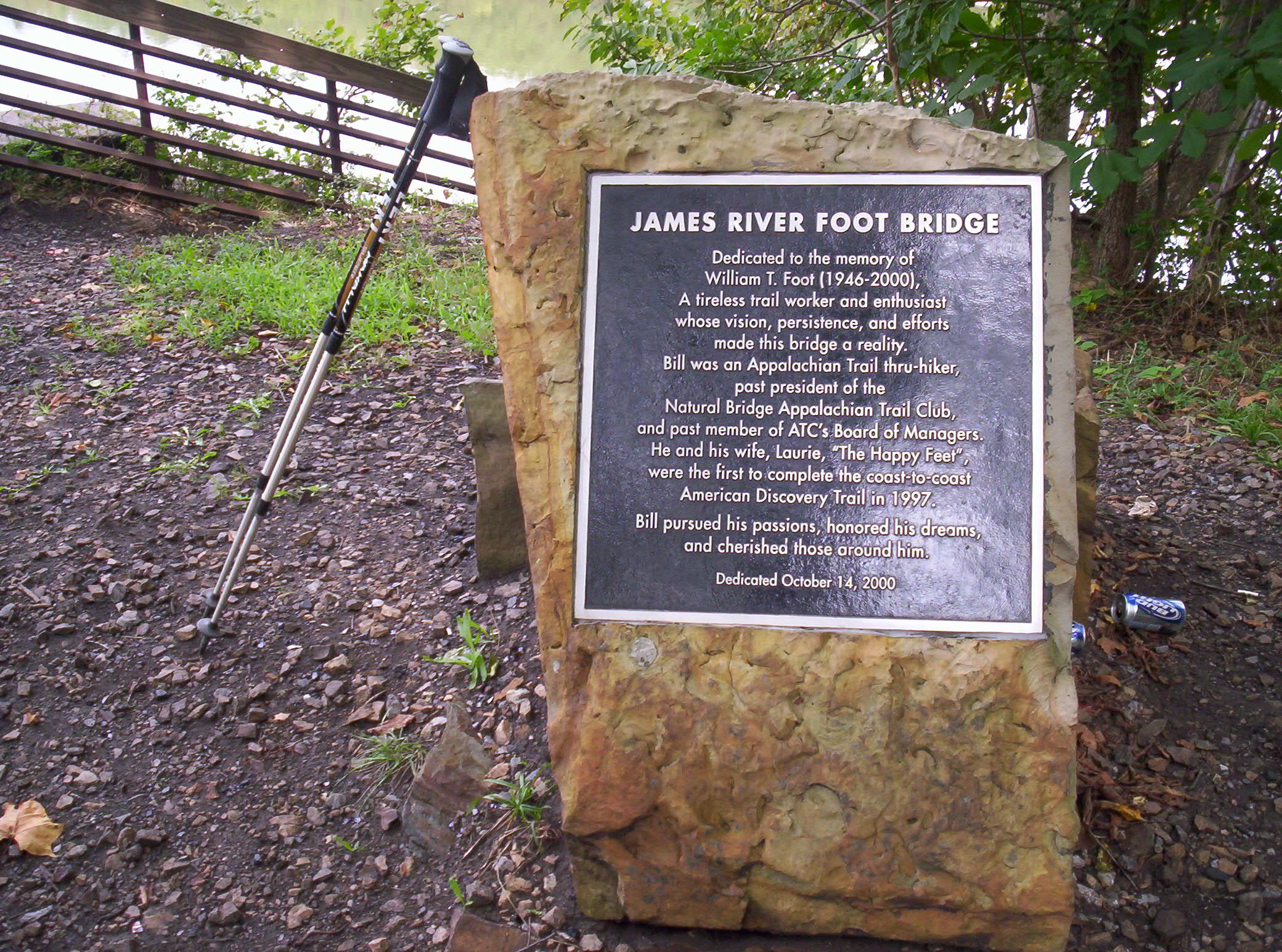


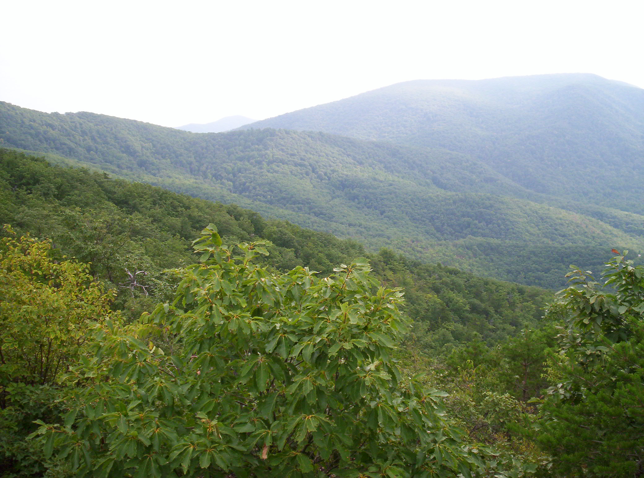


")


")


