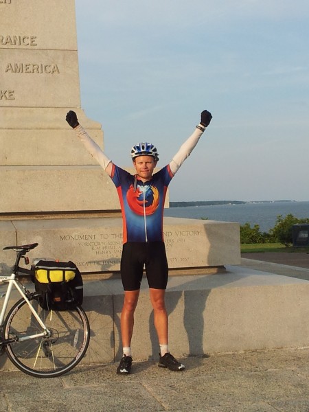
One year ago, after 37 days of biking around ~3875mi total starting in San Francisco, I reached Yorktown, VA to finish biking across the country. An exact day-to-day accounting would likely bog down in uninteresting logistics (particularly given the way I traveled — other approaches would likely yield more interesting day-by-day commentary). Instead, I’m going to cover a variety of topics of interest from the trip, in somewhat random order, in series. If you want a very cursory, sometimes out-of-order account of the trip, reading approximately July 18 to August 25 of my Twitter stream covers it.
An inauspicious start
The trip got off to a bumpy start the Tuesday night before I planned to leave. I planned to ride my spiffy, super-light carbon-fiber racing bike. I use it for regular transport, so I waited to get a final tune-up til the last minute, picking it up the evening before I departed. I began loading it with panniers and gear. Racing bikes don’t have mounts for carrying gear, so I’d use a seatpost rack (with correspondingly light ~16-pound load). When I began attaching the rack, I noticed the clamp matched a much smaller-diameter seatpost. Looking at how the clamp would make contact with the seatpost, it suddenly occurred to me that attaching a seatpost rack to a carbon fiber seatpost might not be a good idea. Carbon fiber is strong along its length, not laterally: the clamp could easily crush the seatpost.
Wednesday morning, I asked the bike shop if they had an aluminum seatpost of the right size. They wouldn’t have one til Friday. Other local shops didn’t have any, either. Replacing the seatpost was out.
Seeing no other options…I went to the first bike shop, bought a non-carbon road bike that fit me, walked home with it, transferred gear and pedals to it, and biked to Caltrain to head to San Francisco to start the trip.
Thus I crossed the country on a bike I bought the day I left.

This is crazy. But not quite as crazy as it sounds. I’d purchased a 2012 Scattante R-570; I’d previously owned the 2010 version, so I knew I’d be comfortable. And months before, I’d considered getting a touring-oriented bike for extra carrying capacity. But I’ve never spent money very easily. I had the money, but I didn’t want to spend it if I didn’t have to.
Now I was in a “have to” situation. Riding a totally untested bike would rightly scare most people to death. Most people would probably cancel the trip or substantially change plans. But my philosophy is that what must be done, can be done. So I did it.
Other than lost biking time (day 1 was 23.76mi route miles rather than the ~100mi I’d intended — no small loss, but not huge, either), all I lost was the ability to buy the bike on sale for ~$160 less. It could have been worse.
Choosing a route
I traveled pretty much entirely with the aid of the Adventure Cycling Association‘s route maps. I considered finding my own route, but I discarded the idea for lack of time and being unsure I’d enjoy route-planning. In hindsight this was clearly the right choice. Unless you enjoy route-planning for its own sake, buy existing cycling maps. You’ll get better routes, and more cycling-useful information, than you can create on the fly. (Plus GPS units cost hundreds of dollars and must be charged every night.)
The 4200-mile TransAmerica Trail goes from Oregon into Montana, southeast to Pueblo in Colorado, then east to Virginia and the coast. It’s the most well-known and commonly-used cross-country route. The 1580-mile Western Express goes from San Francisco to Pueblo. Most people do the TransAmerica because it avoids much waterless desert and elevation change. For me, convenience and available time made the Western Express and eastern TransAmerica a no-brainer.
A definite perk to using an existing route is that the roads will be good for cycling. Often I was on relatively empty back roads, or on state roads with light traffic. The worst roads were in the Rockies in Colorado, likely because of the terrain. The worst regularly-bad road occurred between Cimarron and Sapinero along US-50: a narrow, winding stretch of road with little shoulder and a bunch of RV traffic, where I should have occasionally taken the entire lane rather than let anyone unsafely pass me. Colorado also had the worst irregularly-bad stretches of road, along CO-145 due to road construction. There were two two-mile stretches of riding through gravel where roads were being re-oiled, which I rode through (what choice did I have?) past Motorcycles use extreme caution signs on 700×23 tires (less than an inch wide). Good times. And the stretch from Telluride to Placerville had so much construction dust I sometimes couldn’t see ten feet; I had to stop and turn on head and tail lights to be visible. But generally, ignoring these rare exceptions, the roads were great.
Next time, the daily grind and shelter.


