This is part seven of a series of posts discussing various aspects of a bike trip I did across the United States in 2012. Part one discussed the start of the trip and choosing a route. Part two discussed my daily routine and nightly shelter. Part three discussed general mileage, elevation encountered, and state-by-state scenery. Part four discussed mileage extremes and water. Part five discussed food. Part six discussed elevation extremes, particularly crossing the Continental Divide at Monarch Pass. This post discusses what I did when I was off my bike each day, and how I kept various electronics charged.
Reading during down time
I biked seven to nine hours a day most days, but as long as I roughly kept moving, I’d have down time each day beyond what I’d need for eating and sleeping. With space and weight at a premium, the obvious answer was an ebook reader. So I finally went and got a Kindle: a touch version with 3G, as I expected I might often be places without wifi. I definitely put it to good use, reading these books while gone:
Around the World in Eighty Days (on the flights home — particularly excellent in the context of having just finished an adventure of a trip; the headiness conveyed by the book worked extremely well in that situation)
The Kindle worked extremely well as entertainment: minimal weight and volume, a very wide selection, and (via a case with built-in light) amenable to use anywhere, including inside a tent in darkness. I’d often pull it out over lunch and do some reading while eating, and a handful of times I stopped mid-day and sat and read for awhile. But most of my reading happened just before I went to sleep. I carried headphones and listened to music previously loaded on the Kindle as I read, sometimes. Amazon wasn’t kidding when they called it “experimental”: not even the slightest bit of control over the organization of music, just a single linear playlist based entirely on file creation times. It was adequate, but it certainly wasn’t fully satisfactory.
Power
One issue presented by reading on a Kindle, and by a phone, and by a rechargeable-battery-powered head light with ~3h life (depending on mode), and by a camera with rechargeable battery, was a constant need for power outlets to recharge everything. I barely used (and shouldn’t have brought) the camera, so charging that was never an issue. The others I plugged in every chance I got at the end of the day.
The light needed recharging most often, depending on my recent evening cycling hours. Generally, however, I didn’t bike too long after dark, so the head light never ran too low on me. (I did have two consecutive days with night riding in Kansas where I ran it down to near-empty the second night, and I had a weak backup light ready for use when needed. But I timed it near-perfectly to arrive probably 15-30 minutes before my main light ran out of battery, so I never used the backup, except as a makeshift flashlight when camping.)
I used the phone, plugged in, as an alarm clock when I stayed in motels. (I used my watch for this when camping, due to battery concerns.) Except when plugged in, I turned the phone on only to take pictures or make calls, so its battery didn’t require particular recharging diligence.
The Kindle, of course, required the least recharging effort. Its non-power-drawing screen, and my turning off wireless use, let it do fine with only an occasional recharge. (Although I’m sure the light in the case compensated to some extent for its low power consumption.)
Had I used a GPS unit, I’d have had to plug that in as well, and I’d have needed to charge it more often than I needed to charge anything else I carried. Charging everything else was a minor hassle; I’m glad I didn’t have to deal with the same thing for a GPS unit too. (Although, to be fair, maps have their own problems. In addition to requiring a modicum of effort to not have to carry all ten maps for the full route the entire way, I lost one map out the back pocket of my cycling jersey one day, resulting in an uncomfortable day or so until I found a replacement.)
This is part six of a series of posts discussing various aspects of a bike trip I did across the United States in 2012. Part one discussed the start of the trip and choosing a route. Part two discussed my daily routine and nightly shelter. Part three discussed general mileage, elevation encountered, and state-by-state scenery. Part four discussed mileage extremes and water. Part five discussed food. This post discusses the elevation and ascents I encountered, particularly how I traversed Monarch Pass.
Elevation extremes
The first elevation extreme, Carson Pass, was perhaps the hardest: not for its height, which is only mid-8000s feet, but for its earliness and the length of the ascent. A gradual ascent, but still a long, energy-sapping ascent. Approaching it later in the trip, I’d probably have found it easier.
Only 8500ft? Weaksauce
Kentucky and Virginia had the steepest ascents: never ascending particularly far, but lasting long enough that reaching the top was a relief. If someone wanted to do hill training, setting aside high-altitude benefits, he’d likely be better off training in the Appalachians than in the western states, surprisingly.
Colorado reached the highest elevation of any state. Passing over the highest point at the Continental Divide was possibly the best, and stupidest, part of the entire trip.
Monarch Pass
As usual, I started biking late that morning, and by early afternoon I’d only covered about 40mi. But then I turned it on, reaching the base of the climb to Monarch Pass at 18:15 at ~90mi. From here it was only 10.5mi/2800ft to a tourist store with snacks at the top, then a few miles’ descent to a turnoff to Monarch Campground where I planned to stop. The store closed at 20:00, but if I kept moving I could reach the top before then.
Everything went well with this plan until around 19:00, when it began to rain. Rain is an excellent way to cool down. But in cloudy weather at 10000ft in chill temperatures, it was the last thing I wanted. I didn’t have warm clothes, only the arm warmers I wore constantly (mostly for sun protection), cycling jersey and shorts, and leg warmers if I’d taken the time to put them on (can’t remember if I did — I think I decided that stopping and putting them on, when the rain started, would leave me worse off than continuing to bike would). What to do? It really wasn’t a choice: I had to keep shivering my way to the store before it closed.
I reached the top around 19:52, comfortably just in time, and immediately went inside to snack and warm up. I was doubtless now hypothermic. But between warmth and food, I’d be fine. I got a hot chocolate, a quarter pound of fudge (okay, four ounces, but they sold it as a quarter pound!), and — this was the worst idea in the world, but I’m a sucker for the flavor, so I had to have some — a small cone of peppermint ice cream. After consuming those while slowly warming up, I headed back outside — it was now completely dark and still raining — and began the bike ride down to the campground.
One of the many pictures I took time to take at Monarch Pass
The trip down was dangerous, putting it mildly. The descent was steep and thoroughly wet from the rain. And while I had lights, I also didn’t have very good motor control through my cycling gloves in the cold. I knew I would quickly return to hypothermia, and my hands would only get worse. If I fell or something happened, I was going to be in very deep trouble. So I took it very slow, braking every second or so to not gain speed. I could not afford to crash.
After some period of time between five and twenty minutes, I saw signs for the turnoff to the campground and took it. I proceeded down the road maybe a couple thousand feet without seeing signs for the campground, so I started to worry. Was I on the right road? I was, but I wasn’t sure enough to go too far down it without being certain, so I returned to US-50 and continued to descend. (I knew I had options further down US-50 if that turnoff was the one I wanted.) By this point I was definitely back into hypothermia, and I knew that I was unquestionably staying at the very first place I saw. A short time later I reached Monarch Lodge, where I rolled my bike up, leaned it against an outside wall, and went in and askedmumbled to ask if they had rooms. They did and pointed me to the hot tub and sauna as I obviously needed to warm up. (I was sufficiently cold that the typically-cool pool at the motel actually felt warm when I jumped in it before jumping into the hot tub.) I quickly made use of them and returned to normal body temperature.
Monarch Pass, done that way, was the second-stupidest thing I’ve ever done in my life. (The only thing stupider was walking 51 miles in a day for the Four State Challenge, because I had no good reason at all to do it. It was a totally arbitrary challenge done for no reason except its existence.) It was somewhat pointlessly dangerous, and it might have been nice to experience the full downhill from Monarch Pass at full speed, without missing five or so miles of it in rainy hypothermic darkness. (The first forty miles of the next day were downhill at an average 24mph, so I still got plenty of downhill. 😉 )
But hypothermia and unanticipated rain aside, I knew what I was doing. I knew the condition I was in, and that I had to get warm as soon as possible after reaching the campground or stopping elsewhere. I knew the margins for error in reaching the Monarch Pass store and in descending. And I made the utmost efforts to respect them by pushing hard to reach the pass on time and then to descend as quickly as safely practicable. It was unquestionably dangerous, but it was entirely manageable danger, that I managed with no real issue. If I had to do it over again, I’d do it the exact same way without regrets. (Although I’d definitely give more thought to the possibility of cold rain at elevation, and after-dark riding through it. Not considering that did make for a bit of discomfort, but it didn’t add that much risk, so long as I was careful.)
This is part five of a series of posts discussing various aspects of a bike trip I did across the United States in 2012. Part one discussed the start of the trip and choosing a route. Part two discussed my daily routine and nightly shelter. Part three discussed general mileage, elevation encountered, and state-by-state scenery. Part four discussed mileage extremes and water. This post discusses what I ate during my trip, before, during, and after biking.
Meals
Some people when touring will purchase food in grocery stores and cook with a backpacking stove or similar. This saves money over eating in restaurants, but it requires more time and effort, and it’s extra weight to carry. My goal was to bike across the country, and really nothing more: particularly, not to bike across the country while camping. (Not that there’s anything wrong with that, it just wasn’t a goal this trip.) So I did whatever made sense where I was. In the western parts where I didn’t try to bike quite so far each day, I usually had time to eat in a restaurant for lunch or dinner, perhaps both if I was in the right place. But it depended where I was, and whether anything was available.
It wasn’t uncommon for me to eat out of small food supplies rustled up from a general store. This became much more common after I passed Pueblo, when I reached smoother terrain and needed to make up for lost mileage. By the last couple weeks, I was fairly regularly eating out of gas stations. It wasn’t ideal, and it was not high cuisine, but it got the job done.
The best meal of the entire trip was doubtless the barbecue dinner I had at K&A Chuckwagon in Monticello, UT. The large quantity and variety of traditional Western dishes left me contentedly stuffed. They even gave me a loaf of bread and honey butter to carry and eat the next day — a much-appreciated change from constant candy bars. (Seriously: parents, if you have a kid who likes candy too much, take him on a trip like this with only candy bars to eat for energy. He’ll get so sick of them eventually that he’ll never enjoy eating them again. [Which isn’t to say I’ve reached that point, exactly, but I very rarely eat a candy bar for anything other than energy while exercising, these days.]) If you’re passing through, you absolutely must eat at K&A Chuckwagon. You might also consider staying at Inn at the Canyons, literally across the street. They have a pool, unlike one other place in town they’ll let you take your bike in your room, and you can’t ask for a shorter walk to food after a long day of cycling.
Breakfast
I noticed very quickly that if I hadn’t had breakfast, or a good approximation to it, I dragged in the morning. I always dragged in the morning — I’m not a morning person, and I never really tried to consistently start the day early. But on days when I didn’t have much to eat in the morning, it was noticeably worse. Unfortunately, sometimes this came with the terrain: if there was no place around to eat, I made do with whatever I’d purchased the previous day.
Energy during the day
While cycling I survived on a constant stream of candy bars. Snickers and peanut butter Snickers in particular are generally the best candy bars for this, because they have the most calories per ounce. (Although, it looks like chocolate-peanut-butter-Twix may have recently usurped this throne, judging by experience from my last backpacking trip.) And as the calories are peanut-based, they’re at least slightly more complex and long-lasting than the sugar calories in most candy. (Probably not as good as an actual energy bar, but who wants to eat those? Ugh, they taste awful.) I carried a few to half a dozen candy bars pretty much constantly, depending on planned mileage.
I didn’t plan on it, but often when I stopped to use a bathroom at a gas station, I had more than enough candy for the day’s ride. I had to find something else to nominally pay for the bathroom, and as often as not I’d pick up a Powerade or similar, to break up the monotony of plain water. This worked reasonably well, but I found that it didn’t take much of it for the citric acid in it to trigger mild heartburn. I eased off somewhat after I noticed the correlation, but it was the simplest solution to the problem, so I kept buying them in lesser quantities as I went.
Milk shake mania
On the go, the best recurring snack was doubtless milk shakes. Cold, lots and lots of calories, full of water to rehydrate, lots of flavors — what’s not to like? I stopped at ice cream stores and local soda fountains for shakes (and perhaps lunch) when I had time. But many more times I enjoyed a shake at a gas station, courtesy of the amazing f’real experience. Their concept is a fountain-drink-sized cups mostly filled with ice cream (or blended fruit, but those had fewer calories, so I stuck to the ice cream), in any of various flavors. Then each store has an machine that will add milk and mix up a shake for you. What could possibly be better? (I will admit, however, to wondering who else possibly enjoys these things, as they ranged from 300-700 calories — even crazier than the count in a king-sized [pardon me, “two to go”] candy bar. That’s a huge number of calories to enjoy, not even as an entire meal!) f’real seemed to exist more often in the west than in the east, sadly. And I was particularly disappointed to see that the main gas-station chain in the central states, Casey’s General Store, didn’t have them at all. They’d have made a lot of money off me if they did! (And I wouldn’t have deliberately avoided them hoping to find f’real at other stores.)
Mm, milk shakes
One thing I wish I’d seen while biking was a Cold Stone. I don’t particularly care one way or another for Cold Stone. It’s not bad, but honestly, I don’t really truly notice the higher-quality ice cream enough to make it worth paying for it, usually. But shortly after I returned from the trip I happened to visit a Cold Stone, and I observed that the posted calorie range for a milk shake ranged from ~700 calories up to 2000 calories. I have no idea how you could possibly make a 2000 calorie milk shake! But it would have been about perfect for me, on this trip. (I wonder whether I’d have needed to eat anything else the entire day!)
Calorie-counting
Most people at restaurants order food with fewer calories. Subway prominently advertises calorie counts on everything, for example. I always find these numbers highly amusing on trips like this, because I’m constantly aiming to maximize calorie count as obscenely as I possibly can. 🙂 Low fat? Sugar-free? Pshaw. Pass the butter!
This is part four of a series of posts discussing various aspects of a bike trip I did across the United States in 2012. Part one discussed the start of the trip and choosing a route. Part two discussed my daily routine and nightly shelter. Part three discussed general mileage, elevation encountered, and state-by-state scenery. This post discusses my mileage extremes, and how I dealt with water, particularly in deserts in the west.
Mileage extremes
My shortest non-starting day was 57.63mi in Utah, after the day featuring the longest waterless stretch of the trip (84mi). The motel I stayed at had a very late checkout time, and I was exhausted from the previous day (notwithstanding the multiple meals I ate as dinner at the adjacent 24-hour diner) and stayed past noon. A late-afternoon catastrophic flat cut short any thought of pushing further that day. (It would have been a bad idea anyway, as the next stretch was the 4000ft/25mi stretch in part three.)
He’s dead, Jim
My longest day was 161.47mi from Damascus, VA to Daleville, VA. Five days from the end, I had ~560mi to go, a reasonable closing pace. But a slow start and slowness all day for no particular reason found me only 80mi further, just outside Damascus before dinnertime. As noted earlier, I’d stayed in Damascus when hiking the Appalachian Trail, and I’d visited the town during Trail Days 2009. I had fond memories of the town and would enjoy stopping, even if it was somewhat early. So I resolved to make up the difference by starting super-early the next day. And make up, I did. From start at 0600 to 1100 in Wytheville I put in a solid 80mi. I stopped at the library to book a flight, then to eat lunch. When I looked at a map, I realized I could possibly make it to Daleville — another place I’d visited on the Appalachian Trail. I finished lunch, then hopped on the bike around 1300 and continued with only minor stops to Daleville, arriving ~21:45, to stay at the same motel I’d stayed at four years before. It was a long day, but it wasn’t as tiring as you’d think: I averaged ~15mph for ~11.5h riding, and the distance was more a matter of biking longer than of pushing harder.
Water
Many cyclists get by with water bottles. Some go further with Camelbak or other water bladders on their backs, for greater convenience and capacity. I was traveling through vast expanses of western desert: water would be a huge concern.
Before the trip I used a 100-ounce water bladder when riding. Bladders range from 30-100 ounces, making mine a bit large. But it’s just right for longer trips, such as the fifty miles from Mountain View to Santa Cruz; I usually run near empty by the end of that route. This trip, I’d face much longer distances than 50 miles between water sources, in harsher weather and terrain — several 60-75mi stretches and one 84mi stretch. Based on the Santa Cruz precedent, I bought a second (!) 100-ounce bladder for the trip.
Two bladders worked surprisingly well for all those longer distances. My first taste of empty desert was for the relatively flat fifty miles from Fallon to Middlegate Station in Nevada. As I had little idea how fast I’d consume water, I cautiously filled both bladders in Fallon. I sucked dry on the first one as Middlegate Station came into view, telling me that two ounces per mile was about right in easier desert. (I still fully filled both for the long stretches, to be safe, but I had an idea how fast I’d consume water during them.)
Not too many water faucets out here, even if that doesn’t stop that antelope (?)
The longest waterless stretch was 84mi (as far as I knew — turns out there was a water hose for cyclists about halfway that I didn’t know about 🙁 ), from Baker, NV to Milford, UT. After thirty miles in the morning, I ate lunch in Baker, then left with 200oz. water on my back at around noon-ish. I did myself no favors leaving during the heat of the day, but the Baker grocery store’s opening time, and then the allure of lunch, tempted me into it. (Never underestimate what a good meal can do for energy or morale.) Very quickly I encountered the first real headwinds of the trip, sapping energy more than the heat did. But I kept biking and eating well-melted candy bars, and I kept moving. I emptied one 100oz. water bladder short of 40mi, leaving me slightly worried. But even when water’s scarce, it’s generally better to be hydrated than dehydrated, so I swapped bladders and kept drinking. Eventually I eased up on water to try to stretch it out further, but at mile 72 I sucked dry — well ahead of the distance I’d expect to ride on that water, although not horribly far for the peaks I’d climbed. But I’d successfully stretched the water to my immediate goal: the top of the last pass of the day. So I hunkered down, closed my mouth, and pedaled and coasted downhill the remaining twelve miles. I was thirsty by Milford, but not uncomfortably so: I’d survived the worst of the droughts. It was about the most comfortable way I can imagine to run out of water in the desert.
Next time, food (not that I haven’t been mentioning it every chance I’ve gotten already, I’m sure 🙂 ).
This is part three of a series of posts discussing various aspects of a bike trip I did across the United States in 2012. Part one discussed the start of the trip and choosing a route. Part two discussed my daily routine and nightly shelter. This post discusses mileage, elevation, and the state-by-state scenery.
Mileage and elevation change
Excluding the first day, my daily mileage ranged from a low of 57.63mi to a high of 161.47mi. For the first “half” (psychologically) of the trip til Pueblo, I aimed to not lose ground from my overall target pace but didn’t sweat falling slightly short, and I averaged slightly under 100mi/day (even including that farce of a first day). Nevada’s emptiness strongly regimented my stops and pace. At one point I faced three ~70mi stretches between water, with further logistical challenges beyond: given my time constraints, I had to do two in a 135mi day, then the last plus a bit more the next day. But normally I biked shorter distances til the TransAmerica.
The end of the Western Express in Pueblo marked the start of the Great Plains, where I began to make up lost mileage. In Kansas I discovered 120-130mi was my maximum sustainable pace if I didn’t adjust my schedule to start earlier. Any further and the next day would be an invariably “short” 90-100mi. 120mi let me start somewhat later in the morning (I am absolutely not a morning person), eat reasonable lunches and dinners (if sometimes as gas station takeout), and read awhile before a decent night’s sleep. With more focus I might have started earlier and biked further. But I was on vacation, and I was, er, relaxing. If strict discipline wasn’t necessary, I wouldn’t force it.
That said, 120mi wasn’t always possible. The Missouri section had no difficult elevation, but it did have the Ozarks with an unrelenting sawtooth profile: not enough to exhaust, but enough to slow down the entire day. I eventually gave up on playing mileage catchup til Illinois and settled for not losing ground with ~100mi days.
Cedar City, UT to the red line is around 25mi: uphill but comfortably gradual
East of the Mississippi had arguably more difficult elevation than west. (Carson Pass might be an exception, as a very long ascent so close to the start.) Virginia’s section has more total elevation gain than any other state’s section. Eastern ascents were shorter but much steeper: nothing that couldn’t be handled shifting to lowest gear and spinning, but more exhausting. The steepest lengthy climb was around 4mi/2500ft to the Blue Ridge Parkway in Virginia. In contrast the climb to the Continental Divide was 10.5mi/2800ft.
Scenery and attractions
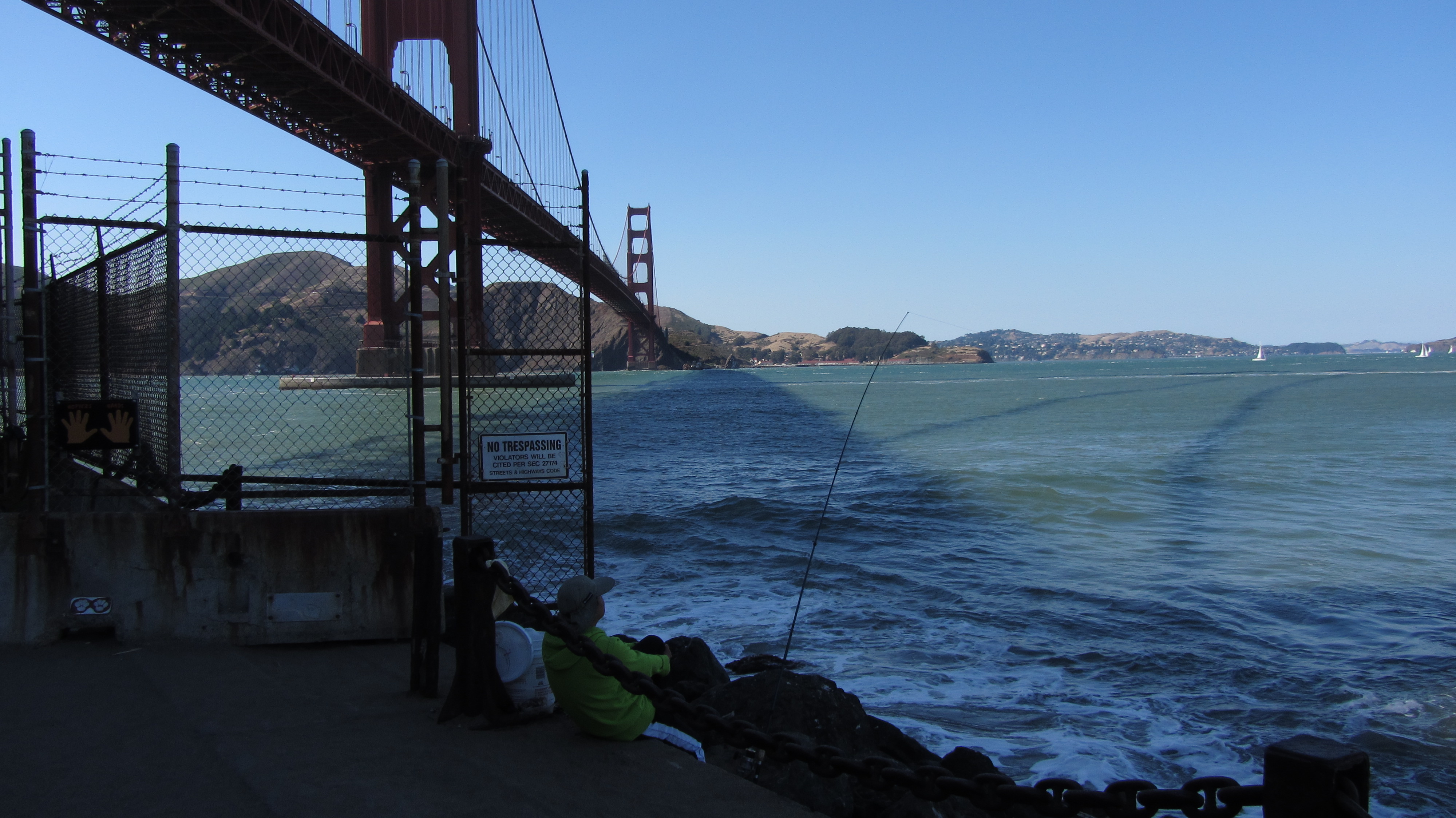
The Golden Gate Bridge, and the start of my trip
California was the least interesting of the western states. The first hundred miles from San Francisco were mostly flat and unvarying: not bad at the start, but still not interesting. The gradual multi-day climb to Carson Pass had its attractions, particularly along California’s SR 88. But California was a short and mostly undistinguished state to bike through, at least along this route.
Of the western states, Nevada was the most majestically desolate. Pass through a basin (carefully winding between mountains), climb to a pass, descend to a basin, and repeat through the entire state. All around were mountains and emptiness; it was the state where I felt most truly alone. (Which as an introvert I consider not a bad thing.) The climbs were never particularly steep, and the descents never astonishingly so, yet I hit ~40mph most days through it. Strangely, of all the states I passed through, I think Nevada is the one I’d most want to return to on bike, even tho it has “nothing” to recommend it.
Nevada’s scenery doesn’t change very quickly, but it’s all beautiful like this
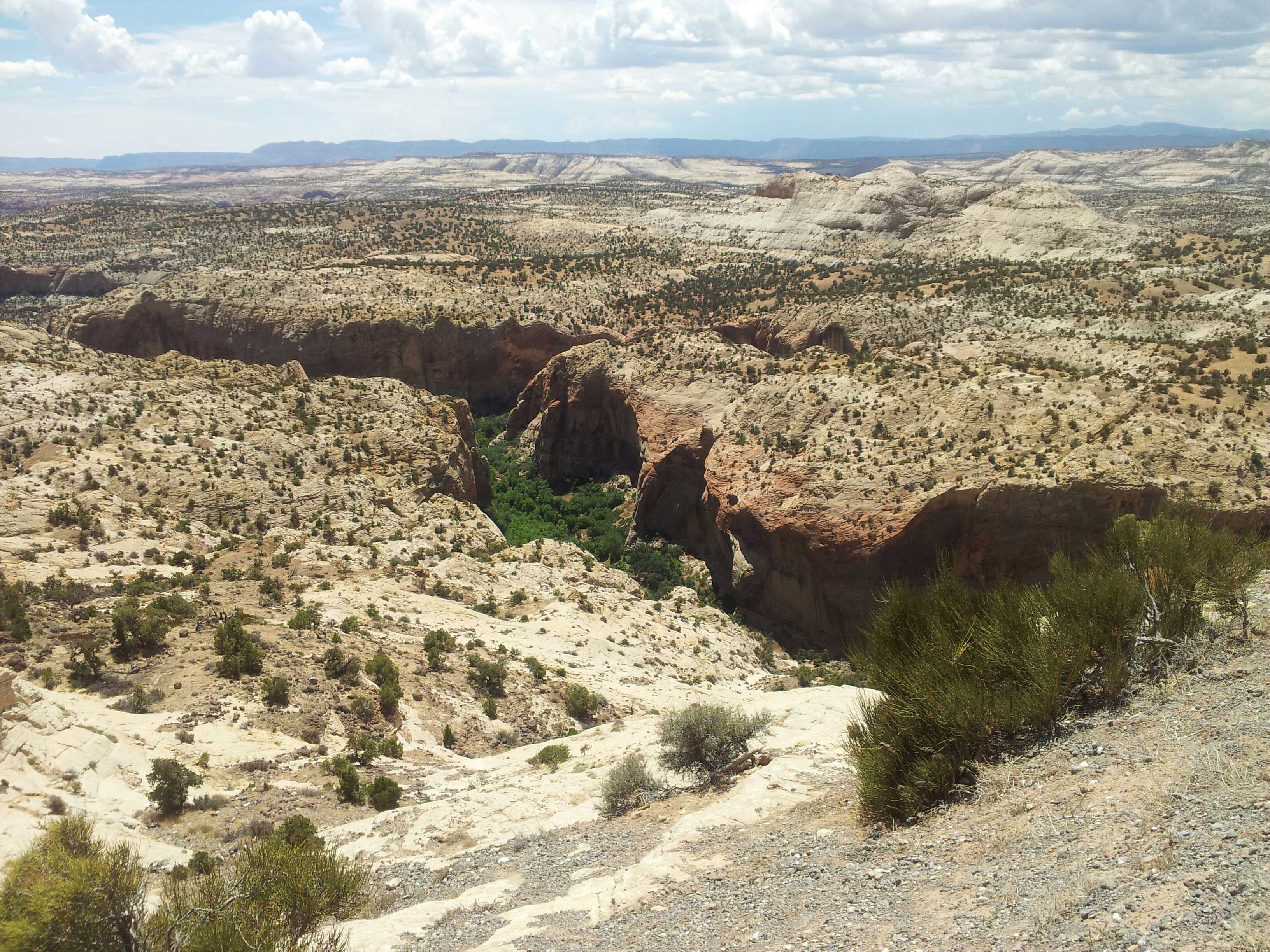
Utah and the mountainous portions of Colorado were much more varied: good in their own ways, yet not in Nevada’s unique way. After that initial 84mi waterless stretch (from just in Nevada to well into Utah), I encountered irrigated farmland, red sandstone rock formations, and a good variety of desert vegetation. The empty stretches didn’t have the consistency of terrain that Nevada’s did. I did pass through emptiness, but that emptiness carved across mountainsides, descended into and out of valleys, and passed through several national parks with incredible scenery. Nevada’s uniqueness aside, Utah and Colorado were the best states of the trip.
A sampling of Utah’s varied vegetation and scenery
West of Pueblo turned into the Great Plains: the tail end of Colorado, and Kansas. The riding is basically flat, with mercurially-shifting prairie winds kicking in to keep things interesting. Even crosswinds that aren’t actually impeding you can really sap energy. The Colorado portion wasn’t particularly different from the Kansas portion, except that the local towns along CO-96 banded together to create the Prairie Horizons Trail — a naming and sprucing up of the stretch to particularly accommodate touring cyclists, complete with map listing services at locations along the way. It was definitely a nice touch. 🙂 Kansas was much the same, excepting that the route traveled many different roads, slowly cutting south as it crossed the state. Both routes were notable for their sheer emptiness: not in the desolate manner of Nevada, but in the way that, leaving one town, you could see the grain elevator in the next town, and the utter lack of anything but fields of grain before it.
Sunset colors in Kansas as nighttime riding beckons
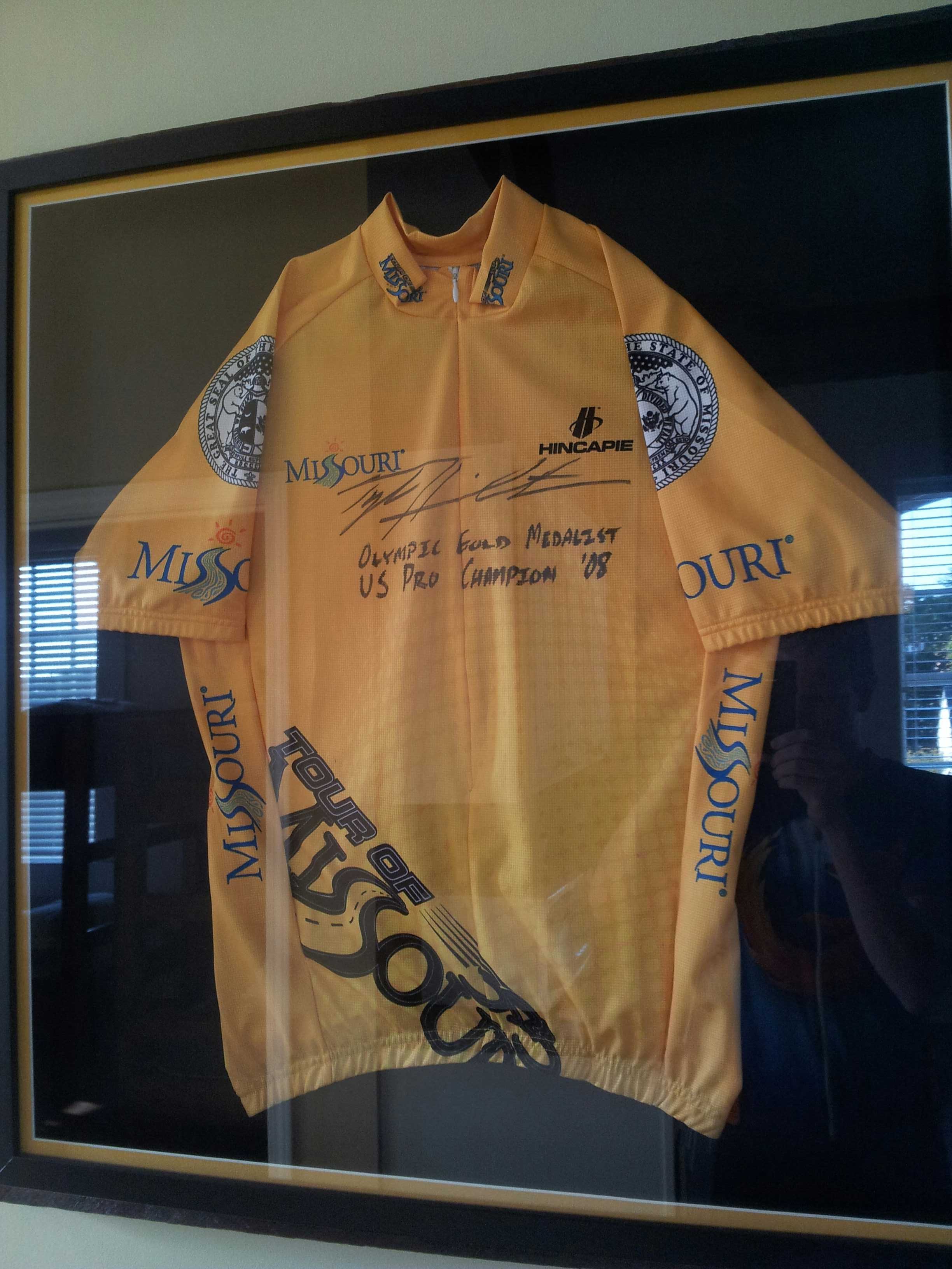
Missouri was my least favorite state for two reasons. I’ve already mentioned its sawtooth climbs and descents. The second reason is that Missouri was one of only two states where I was ever aggressively chased by dogs. This was not a rare occurrence: it happened multiple times, including a couple times in complete darkness. Fortunately, I was able to bike just fast enough that dogs that appeared to have every intention of attacking me could only just keep pace with me til I left their home ranges. I evaded them all, but always with a fast-pounding heart afterward. Missouri did have Al’s Place, the nicest hostel of the entire trip — a former (converted) jail run as a hostel for cross-country cyclists.
A jersey that, er, “graces” Al’s Place; my timing seeing it on August 12 was impeccable
Illinois was a short and sweet state I passed through in about a day, near the southern tip. It had the Mississippi and Ohio rivers at start and end to recommend it, but it was mostly uneventful. It played host to the worst rainstorm of the trip, which passed over me during a brief gas station stop. I delayed leaving an extra fifteen minutes to avoid biking in briefly-torrential rain; it would have been impossible to see through it while riding. Its other attraction was the milk shake at Rose Kountry Kitchen in Cave-In-Rock. I ordered it sight unseen before looking at a menu. When I looked at the menu I discovered there were two sizes; I quickly upgraded my request to the 32-ounce (!) size, to much astonishment from the restaurant staff. There’s nothing better than that many calories, as ice cream, while biking.
The ferry across the Ohio was one of my more unique moments of travel
Kentucky, sad to say, was at times the grungiest state of the trip. The graffiti on the state welcome sign just past the Ohio didn’t bode well. And the many run-down homes and trailer homes on the many back roads on which I traveled only confirmed this. And Kentucky’s dogs were probably the worst of the entire trip. TransAm cyclists told me of other cyclists who’d had to get stitches from dog bites suffered in Kentucky. I evaded any bites, but as in Missouri, it was very stressful doing so. The best part of Kentucky, however, was the Utica Fire Department, which lets cyclists stay in the volunteer fire station overnight; I particularly appreciated it after a ~142mi day. I just wish I’d been able to say hi to more firefighters while I was there.
Welcome to Kentucky 😐
Virginia presented the Appalachians, the Atlantic, and the end of the trip. Virginia’s route paralleled the Appalachian Trail for awhile, giving me the opportunity to briefly revisit many places I’d visited four years before. I stopped early in Damascus, partly from tiredness, partly to stay at The Place, a hostel I’d visited while hiking the A.T., partly for a good dinner, and partly to make an early start on the mother of all days the next day. (More on that later.) My mileage worked out just right so that my last day was a pleasurable hundred miles into Yorktown — made slightly hectic by two broken rear spokes with 25mi remaining, yet leaving me several hours in the evening for a good dinner, ice cream, and a beer. Grace Episcopal Church hosted me as a cyclist on this last night, giving me an opportunity to wash laundry and clean myself up before heading to Norfolk to fly back to California the next day. (Yes, this cut it close, but I was fairly sure it was always going to be that way.)