This is part four of a series of posts discussing various aspects of a bike trip I did across the United States in 2012. Part one discussed the start of the trip and choosing a route. Part two discussed my daily routine and nightly shelter. Part three discussed general mileage, elevation encountered, and state-by-state scenery. This post discusses my mileage extremes, and how I dealt with water, particularly in deserts in the west.
Mileage extremes
My shortest non-starting day was 57.63mi in Utah, after the day featuring the longest waterless stretch of the trip (84mi). The motel I stayed at had a very late checkout time, and I was exhausted from the previous day (notwithstanding the multiple meals I ate as dinner at the adjacent 24-hour diner) and stayed past noon. A late-afternoon catastrophic flat cut short any thought of pushing further that day. (It would have been a bad idea anyway, as the next stretch was the 4000ft/25mi stretch in part three.)
He’s dead, Jim
My longest day was 161.47mi from Damascus, VA to Daleville, VA. Five days from the end, I had ~560mi to go, a reasonable closing pace. But a slow start and slowness all day for no particular reason found me only 80mi further, just outside Damascus before dinnertime. As noted earlier, I’d stayed in Damascus when hiking the Appalachian Trail, and I’d visited the town during Trail Days 2009. I had fond memories of the town and would enjoy stopping, even if it was somewhat early. So I resolved to make up the difference by starting super-early the next day. And make up, I did. From start at 0600 to 1100 in Wytheville I put in a solid 80mi. I stopped at the library to book a flight, then to eat lunch. When I looked at a map, I realized I could possibly make it to Daleville — another place I’d visited on the Appalachian Trail. I finished lunch, then hopped on the bike around 1300 and continued with only minor stops to Daleville, arriving ~21:45, to stay at the same motel I’d stayed at four years before. It was a long day, but it wasn’t as tiring as you’d think: I averaged ~15mph for ~11.5h riding, and the distance was more a matter of biking longer than of pushing harder.
Water
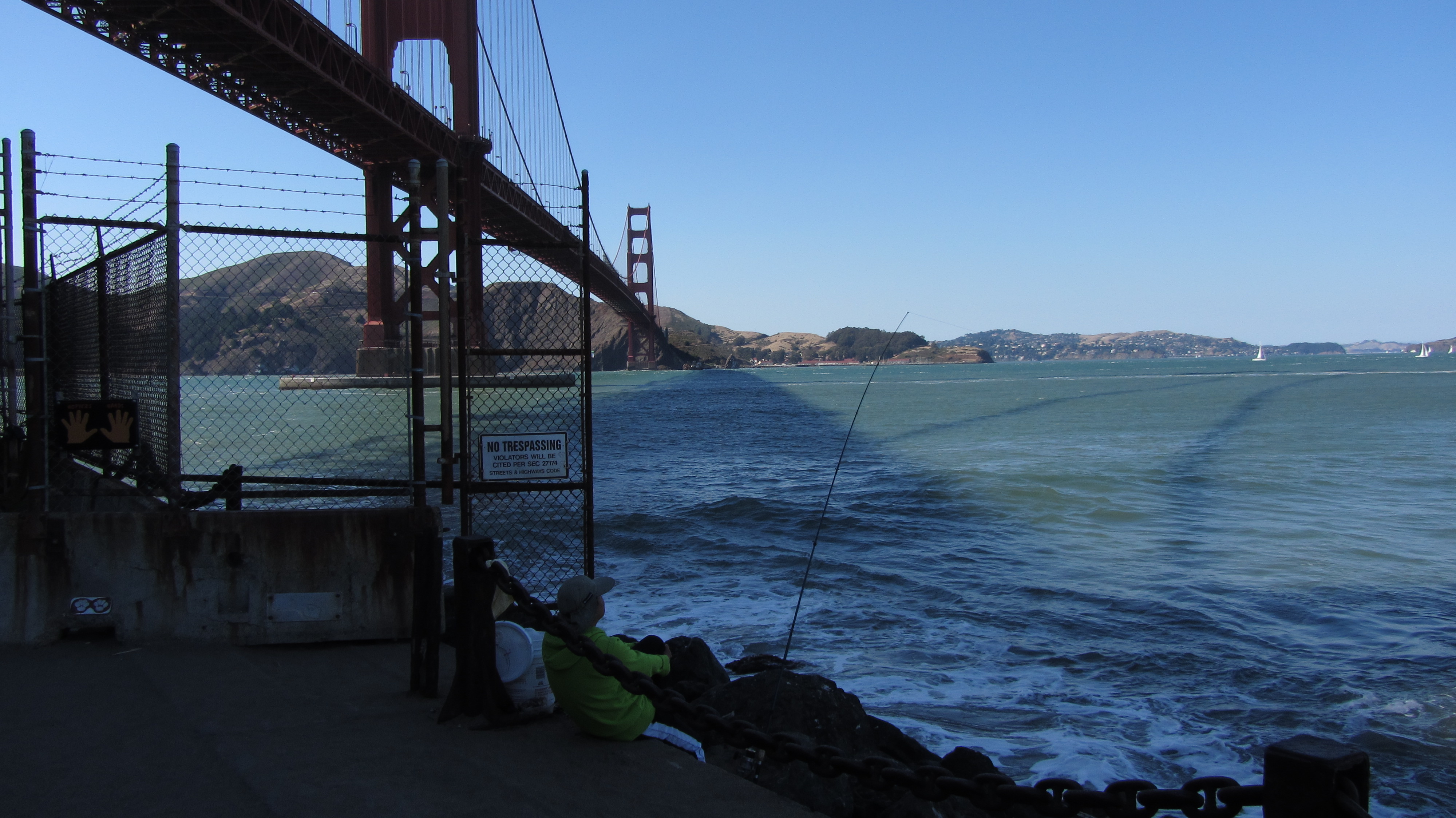
Many cyclists get by with water bottles. Some go further with Camelbak or other water bladders on their backs, for greater convenience and capacity. I was traveling through vast expanses of western desert: water would be a huge concern.
Before the trip I used a 100-ounce water bladder when riding. Bladders range from 30-100 ounces, making mine a bit large. But it’s just right for longer trips, such as the fifty miles from Mountain View to Santa Cruz; I usually run near empty by the end of that route. This trip, I’d face much longer distances than 50 miles between water sources, in harsher weather and terrain — several 60-75mi stretches and one 84mi stretch. Based on the Santa Cruz precedent, I bought a second (!) 100-ounce bladder for the trip.
Two bladders worked surprisingly well for all those longer distances. My first taste of empty desert was for the relatively flat fifty miles from Fallon to Middlegate Station in Nevada. As I had little idea how fast I’d consume water, I cautiously filled both bladders in Fallon. I sucked dry on the first one as Middlegate Station came into view, telling me that two ounces per mile was about right in easier desert. (I still fully filled both for the long stretches, to be safe, but I had an idea how fast I’d consume water during them.)
Not too many water faucets out here, even if that doesn’t stop that antelope (?)
The longest waterless stretch was 84mi (as far as I knew — turns out there was a water hose for cyclists about halfway that I didn’t know about 🙁 ), from Baker, NV to Milford, UT. After thirty miles in the morning, I ate lunch in Baker, then left with 200oz. water on my back at around noon-ish. I did myself no favors leaving during the heat of the day, but the Baker grocery store’s opening time, and then the allure of lunch, tempted me into it. (Never underestimate what a good meal can do for energy or morale.) Very quickly I encountered the first real headwinds of the trip, sapping energy more than the heat did. But I kept biking and eating well-melted candy bars, and I kept moving. I emptied one 100oz. water bladder short of 40mi, leaving me slightly worried. But even when water’s scarce, it’s generally better to be hydrated than dehydrated, so I swapped bladders and kept drinking. Eventually I eased up on water to try to stretch it out further, but at mile 72 I sucked dry — well ahead of the distance I’d expect to ride on that water, although not horribly far for the peaks I’d climbed. But I’d successfully stretched the water to my immediate goal: the top of the last pass of the day. So I hunkered down, closed my mouth, and pedaled and coasted downhill the remaining twelve miles. I was thirsty by Milford, but not uncomfortably so: I’d survived the worst of the droughts. It was about the most comfortable way I can imagine to run out of water in the desert.
Next time, food (not that I haven’t been mentioning it every chance I’ve gotten already, I’m sure 🙂 ).
This is part three of a series of posts discussing various aspects of a bike trip I did across the United States in 2012. Part one discussed the start of the trip and choosing a route. Part two discussed my daily routine and nightly shelter. This post discusses mileage, elevation, and the state-by-state scenery.
Mileage and elevation change
Excluding the first day, my daily mileage ranged from a low of 57.63mi to a high of 161.47mi. For the first “half” (psychologically) of the trip til Pueblo, I aimed to not lose ground from my overall target pace but didn’t sweat falling slightly short, and I averaged slightly under 100mi/day (even including that farce of a first day). Nevada’s emptiness strongly regimented my stops and pace. At one point I faced three ~70mi stretches between water, with further logistical challenges beyond: given my time constraints, I had to do two in a 135mi day, then the last plus a bit more the next day. But normally I biked shorter distances til the TransAmerica.
The end of the Western Express in Pueblo marked the start of the Great Plains, where I began to make up lost mileage. In Kansas I discovered 120-130mi was my maximum sustainable pace if I didn’t adjust my schedule to start earlier. Any further and the next day would be an invariably “short” 90-100mi. 120mi let me start somewhat later in the morning (I am absolutely not a morning person), eat reasonable lunches and dinners (if sometimes as gas station takeout), and read awhile before a decent night’s sleep. With more focus I might have started earlier and biked further. But I was on vacation, and I was, er, relaxing. If strict discipline wasn’t necessary, I wouldn’t force it.
That said, 120mi wasn’t always possible. The Missouri section had no difficult elevation, but it did have the Ozarks with an unrelenting sawtooth profile: not enough to exhaust, but enough to slow down the entire day. I eventually gave up on playing mileage catchup til Illinois and settled for not losing ground with ~100mi days.
Cedar City, UT to the red line is around 25mi: uphill but comfortably gradual
East of the Mississippi had arguably more difficult elevation than west. (Carson Pass might be an exception, as a very long ascent so close to the start.) Virginia’s section has more total elevation gain than any other state’s section. Eastern ascents were shorter but much steeper: nothing that couldn’t be handled shifting to lowest gear and spinning, but more exhausting. The steepest lengthy climb was around 4mi/2500ft to the Blue Ridge Parkway in Virginia. In contrast the climb to the Continental Divide was 10.5mi/2800ft.
Scenery and attractions
The Golden Gate Bridge, and the start of my trip
California was the least interesting of the western states. The first hundred miles from San Francisco were mostly flat and unvarying: not bad at the start, but still not interesting. The gradual multi-day climb to Carson Pass had its attractions, particularly along California’s SR 88. But California was a short and mostly undistinguished state to bike through, at least along this route.
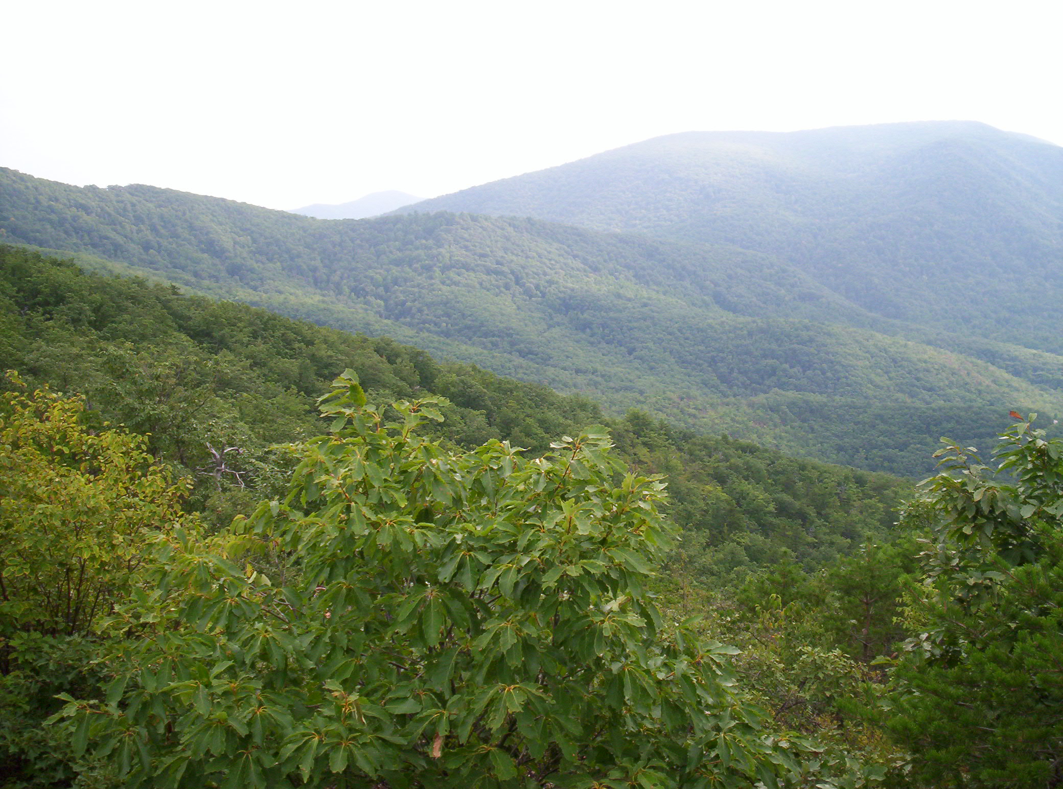
Of the western states, Nevada was the most majestically desolate. Pass through a basin (carefully winding between mountains), climb to a pass, descend to a basin, and repeat through the entire state. All around were mountains and emptiness; it was the state where I felt most truly alone. (Which as an introvert I consider not a bad thing.) The climbs were never particularly steep, and the descents never astonishingly so, yet I hit ~40mph most days through it. Strangely, of all the states I passed through, I think Nevada is the one I’d most want to return to on bike, even tho it has “nothing” to recommend it.
Nevada’s scenery doesn’t change very quickly, but it’s all beautiful like this
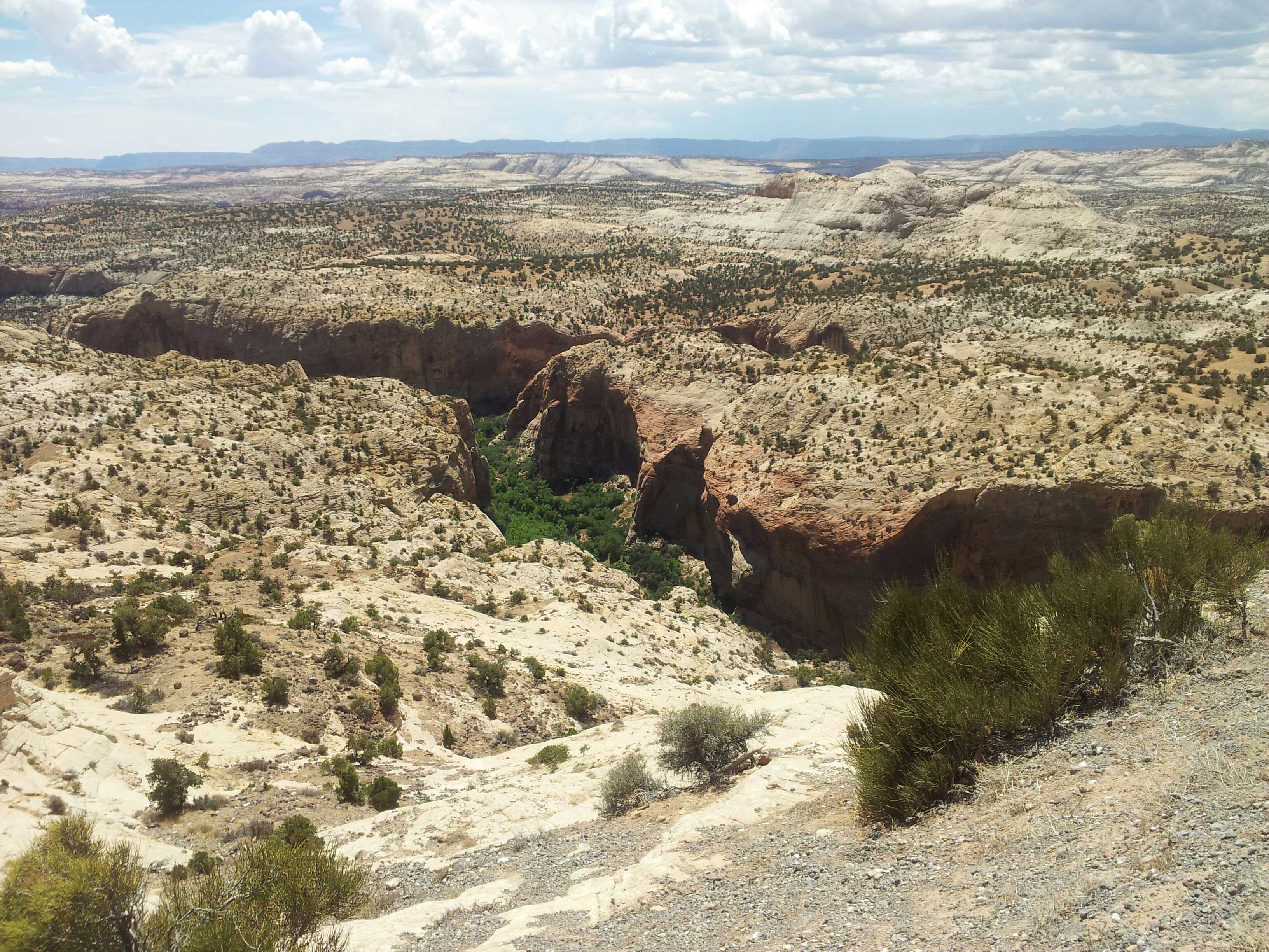
Utah and the mountainous portions of Colorado were much more varied: good in their own ways, yet not in Nevada’s unique way. After that initial 84mi waterless stretch (from just in Nevada to well into Utah), I encountered irrigated farmland, red sandstone rock formations, and a good variety of desert vegetation. The empty stretches didn’t have the consistency of terrain that Nevada’s did. I did pass through emptiness, but that emptiness carved across mountainsides, descended into and out of valleys, and passed through several national parks with incredible scenery. Nevada’s uniqueness aside, Utah and Colorado were the best states of the trip.
A sampling of Utah’s varied vegetation and scenery
West of Pueblo turned into the Great Plains: the tail end of Colorado, and Kansas. The riding is basically flat, with mercurially-shifting prairie winds kicking in to keep things interesting. Even crosswinds that aren’t actually impeding you can really sap energy. The Colorado portion wasn’t particularly different from the Kansas portion, except that the local towns along CO-96 banded together to create the Prairie Horizons Trail — a naming and sprucing up of the stretch to particularly accommodate touring cyclists, complete with map listing services at locations along the way. It was definitely a nice touch. 🙂 Kansas was much the same, excepting that the route traveled many different roads, slowly cutting south as it crossed the state. Both routes were notable for their sheer emptiness: not in the desolate manner of Nevada, but in the way that, leaving one town, you could see the grain elevator in the next town, and the utter lack of anything but fields of grain before it.
Sunset colors in Kansas as nighttime riding beckons
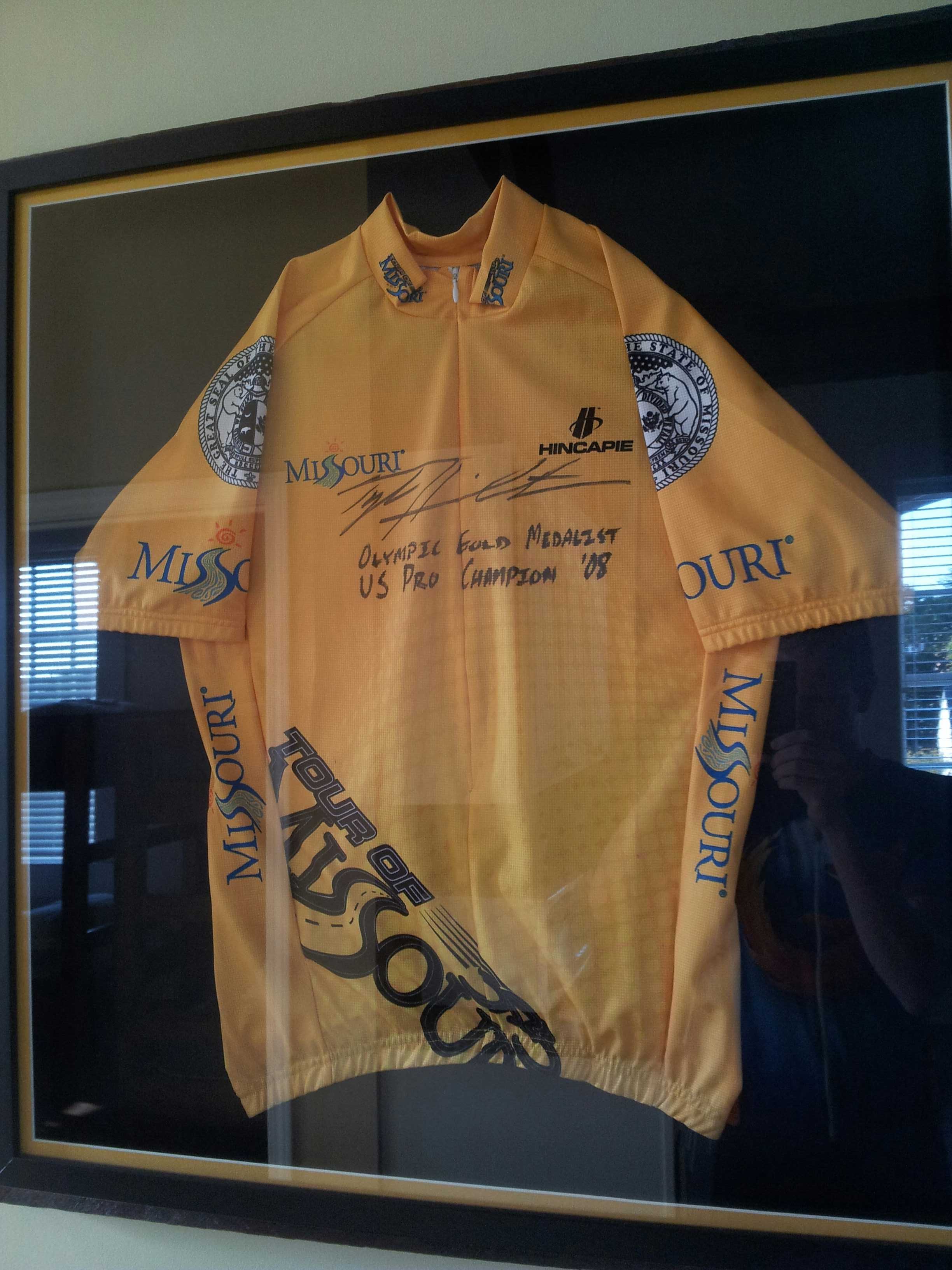
Missouri was my least favorite state for two reasons. I’ve already mentioned its sawtooth climbs and descents. The second reason is that Missouri was one of only two states where I was ever aggressively chased by dogs. This was not a rare occurrence: it happened multiple times, including a couple times in complete darkness. Fortunately, I was able to bike just fast enough that dogs that appeared to have every intention of attacking me could only just keep pace with me til I left their home ranges. I evaded them all, but always with a fast-pounding heart afterward. Missouri did have Al’s Place, the nicest hostel of the entire trip — a former (converted) jail run as a hostel for cross-country cyclists.
A jersey that, er, “graces” Al’s Place; my timing seeing it on August 12 was impeccable
Illinois was a short and sweet state I passed through in about a day, near the southern tip. It had the Mississippi and Ohio rivers at start and end to recommend it, but it was mostly uneventful. It played host to the worst rainstorm of the trip, which passed over me during a brief gas station stop. I delayed leaving an extra fifteen minutes to avoid biking in briefly-torrential rain; it would have been impossible to see through it while riding. Its other attraction was the milk shake at Rose Kountry Kitchen in Cave-In-Rock. I ordered it sight unseen before looking at a menu. When I looked at the menu I discovered there were two sizes; I quickly upgraded my request to the 32-ounce (!) size, to much astonishment from the restaurant staff. There’s nothing better than that many calories, as ice cream, while biking.
The ferry across the Ohio was one of my more unique moments of travel
Kentucky, sad to say, was at times the grungiest state of the trip. The graffiti on the state welcome sign just past the Ohio didn’t bode well. And the many run-down homes and trailer homes on the many back roads on which I traveled only confirmed this. And Kentucky’s dogs were probably the worst of the entire trip. TransAm cyclists told me of other cyclists who’d had to get stitches from dog bites suffered in Kentucky. I evaded any bites, but as in Missouri, it was very stressful doing so. The best part of Kentucky, however, was the Utica Fire Department, which lets cyclists stay in the volunteer fire station overnight; I particularly appreciated it after a ~142mi day. I just wish I’d been able to say hi to more firefighters while I was there.
Welcome to Kentucky 😐
Virginia presented the Appalachians, the Atlantic, and the end of the trip. Virginia’s route paralleled the Appalachian Trail for awhile, giving me the opportunity to briefly revisit many places I’d visited four years before. I stopped early in Damascus, partly from tiredness, partly to stay at The Place, a hostel I’d visited while hiking the A.T., partly for a good dinner, and partly to make an early start on the mother of all days the next day. (More on that later.) My mileage worked out just right so that my last day was a pleasurable hundred miles into Yorktown — made slightly hectic by two broken rear spokes with 25mi remaining, yet leaving me several hours in the evening for a good dinner, ice cream, and a beer. Grace Episcopal Church hosted me as a cyclist on this last night, giving me an opportunity to wash laundry and clean myself up before heading to Norfolk to fly back to California the next day. (Yes, this cut it close, but I was fairly sure it was always going to be that way.)
(5.0; 1330.9 total, 843.1 to go; -10.0 from pace, -109.1 overall)
After this brief interlude with family, it’s time to get moving again. Mom makes some effort to get me to not hike for another day, but I’m somewhat leery of taking two zeroes as I’ve never done so before, and I dig in my heels. I’m back on the trail shortly after 11:00.
It’s only five miles to the first shelter, and strangely I complete them at a three-miles-an-hour pace despite it not being the afternoon, eating a Granny Smith apple as I hike. Mm, delicious absurdly heavy foods…. I arrive at the shelter to unexpectedly find someone there — Smoothie again! He’s now hiking for a few days with a girl he met at a yoga class in Delaware Water Gap. I stop to eat and lighten my pack, pulling out a loaf of raisin bread to attack. Between the weighty pack and another southbounder I’m not in much of a rush to get moving again; when the Honeymooners walk up, my plans to hike further today vanish. Four southbounders all in one place — it’s been ages since this has happened to me.
But wait, there’s more! In walks a hiker with her father, and she looks familiar — turns out it’s Kat, whom I met at Wintturi Shelter back in Vermont. I’d thought she was a northbounder, but it seems she’s really flip-flopping around Waynesboro, hiking south for a few days with her father before he heads back to work. So, all total we have five different thru-hikers here for the night, four of them true southbounders — crazy…
The rest of the day is pretty lackadaisical. The only memorable bit occurs while I’m making dinner, something Knorr-ish as usual. Smoothie’s hiking companion, a vegetarian, looks aghast at the amount of sodium in my overall meal; she calculates somewhere around 2000mg total. I take a look and see she’s wrong — one of my food items is actually two servings, not one. Mm, sodium…
September 13
(15.8; 1346.7 total, 827.3 to go; +0.8 from pace, -108.3 overall)
Today’s goal is a shelter about twenty miles south, but my hiking pace just isn’t feeling up to it,. It’s starting to get pretty dry, and water is somewhat scarce. I hike south in the latter half of the mob moving south: Honeymooners in front, Smoothie and girlfriend next, me, then Kat and her dad, in rough order. I last see Kat maybe a dozen miles into the day when I stop briefly at a road crossing to eat an apple; I assume they’re heading to the next shelter a few miles south, but after I leave it sounds like they made a very abrupt decision to spend the night in town; combined with my pace this is therefore the last time I see them.
The morning's view
I travel the next several miles to Maupin Field Shelter, arriving maybe around 17:00. I plan to only briefly stop to fill up on water, but a certain lack of energy, plus the meagerness of the water source, mean it makes more sense for me to stop for the night here. The shelter is initially occupied by someone who’s set up his tent in it; I don’t mind this when a shelter’s empty enough, but it’s not here. Eventually enough people show up that I manage to argue the owner into moving into a perfectly serviceable campsite instead. Besides Smoothie and companion there are a couple random backpackers and one flip-flopper named Toad. Toad’s from Pennsylvania somewhere around Pine Grove Furnace State Park, and he started near there June 7, hiked north, then flipped back to hike south again. He carries a rather large Jetboil stove with him as a luxury item. The Honeymooners are characteristically efficient in their hiking and thus end up at Harpers Creek Shelter about five miles south, rather than this one. (They later express surprise I didn’t make it there; I do tend to be a bit erratic in my pace at times.)
Even later yet, however, another backpacker arrives, and from our (Smoothie, Toad, me) first sight of him alone it’s clear he’s a very special hiker. He’s lean and thin, he’s hiking quickly with poles pumping, and his backpack — if you can call it that — isn’t much more than Camelbak-sized. (He tells us his base weight — what he always carries, then additionally supplemented with food and water, is something like four pounds. Total, he’s at about a dozen.) This guy’s someone we’re going to see tonight and never see again. Brian (no trail name, nobody sees him long enough for him to pick one up) isn’t just a crazy thru-hiker, he’s a yo-yo. (That’s a technical term: he’s hiking the Trail first one direction, then the other, so south to north, then north to south, all at once, for a total of 4352.4 miles by his count.) You might think he runs when he hikes, but really he just hikes at a good pace without stopping. He hikes maybe 2.8 miles an hour, which is actually slower than my comfortable top pace when I reach it. I stop way more, and I don’t always hit that pace, and start to stop I probably am out shorter periods of time, so overall I travel comfortably less distance than he does, and I’m not really a slouch by thru-hiking standards myself. We see him tonight and tomorrow morning, then never again. (One last comparison to illustrate the enormity of his hiking prowess: he takes 24 days to hike the remaining 827.3 miles, ending October 7; I take 42 and end October 25.) It’s amusing to contemplate a pace like that, but I couldn’t do it over the long haul. Nevertheless, Hike Your Own Hike.
September 14
(20.5; 1367.2 total, 806.8 to go; +5.5 from pace, -102.8 overall)
I get a good start on the day today with an early (for me) departure, which I then promptly squander/invest in stopping at the following vista for awhile to enjoy the view and eat an apple:
The morning view from Hanging Rock Vista (I think); the mountain in the distance is The Priest
The nearby mountain in that picture is The Priest, and my hiking today goes down, then up and over it. It’s the first elevation above 4000 feet since Massachusetts: the long stretch of relative flatness is ending. Still, the ascents aren’t tiring or steep like Maine or New Hampshire were. I’m sure at least some are comparable, but for the most part I barely notice them as requiring extra physical exertion: it’s where the trail goes, and thus I follow it. It’s so nice to be in thru-hiker shape. As you can see I’m at a bit of an elevation for that picture, and I stay up for a little longer before starting the descent all the way to the bottom of the valley (in preparation for the ascent right back up the other side 🙂 ).
A view a little later, with Three Ridges in the distance
And panned a little
The descent from the heights is great as I pass by Harpers Creek Shelter, refilling on water from the creek. South and down from there I pass over the Tye River and a road crossing, then it’s up the other side again. By now it’s mid-day, and the physical exertion plus beating sun make it pretty hot. The view from the top is great:
The view from near the top of The Priest
Past there it’s only a mile or so, descending to a slightly lower elevation, to reach The Priest Shelter where, as usual, I stop to read the register and get a bite to eat. This register is particularly memorable for being placed by northbounder Don Juan, who declares that entries must, being near “the priest”, make a confession of some sort; it makes for entertaining reading. My “confession”, I’m certain, some would call a conceit: I confess that I don’t think someone who hikes the Trail in segments over extended time deserves to be called a thru-hiker. (The ATC explicitly recognizes anyone who walks or makes a good faith effort to walk the entire trail, ignoring timing, carrying of supplies or not, &c. However, they recognize with the moniker “2000-Miler”, in reference to the original expected length of the Trail, and they don’t distinguish anyone as a thru-hiker.) To me a thru-hike implies, well, that you began the hike, hiked through the trail, and completed the hike, all in one go. You didn’t hike part, stop, then hike more of it some vastly different time, and so on until completion, you started hiking and didn’t fully return to non-hiking life until you’d walked every bit of the trail. Even flip-floppers kind of leave me feeling a little weird due to “through” being a little twisted geographically, but they do hike the entire thing, in one go, without stopping, so it’s enough for me. A section hiker still can claim to have walked the entire Trail, which is certainly no mean feat! He just shouldn’t (by my opinion, take it or leave it) imply he hiked it all at once by calling it a thru-hike. (As I’ve noted before, I’ll make one exception to this rule: the northbounder K1YPP, who claims his medically-required triple-bypass surgery caused him to take “three hundred zeroes”, for the sheer audacity of the claim 🙂 .)
At this point Toad catches up to me and stops for the day. It’s still before 17:00 or so, I haven’t done enough mileage to be above pace yet, and it’s not that much further (couple hours or so) to get to Seeley-Woodworth Shelter, so I head on. Smoothie and the girl he met are jumping off the trail again at a road crossing near here, so I’m pretty sure I’ll be alone at the shelter for the night, which does turn out to be the case. Seeley-Woodworth is most memorable for its spectacular water source: a piped spring with excellent clear water practically gushing out of it, the best water source on the entire Trail in my opinion. The shelter has a bag of wild apples hanging from one of its vertical supports, and I avail myself of a few. I still have Granny Smith apples from the store (have I mentioned how weight-unconscious a backpacker I am?), but wild apples have a different flavor — stronger, but not necessarily better, and variety is good. Also, in a bizarre occurrence, I find what I think is a tick on one of my toes tonight, in a location so far within boot and sock that I have no idea how it could possibly have gotten there.
Future plans now begin to impose upon my hiking schedule, as I consider when I’ll reach where, with whom, and so on. I have enough food to reach Daleville, ninety miles south, and ideally I’d like to stay there for the night. Unfortunately, since I’m near the front of the southbounder pack, and as Daleville doesn’t have hostel-style accommodations, doing so could be expensive. There aren’t any southbounders that close in front of me with whom I could split a room, and I’m not aware of anyone sufficiently close behind, either, that’s likely to hike far and fast enough to catch up. (Smoothie, as far as I can tell, doesn’t usually hike the sort of days I’ll be hiking over the next few days, although he’s certainly capable of doing so.) Further compounding the problem is that Daleville’s at the start of a 26-mile section of trail where camping is only permitted at a few specific sites, the first being nine miles in — so resupply in Daleville without staying longer means I have to reach it by midday. Camping between here and there means the most plausible schedule involves me hiking 24, 25, 24, and 18 miles the next several days (and maybe nine more the last day if I can’t figure out a way to stay in Daleville without spending more than I want to do so), so it looks like my schedule is going to be fairly inflexible for the next several days. None of the mileage is excessive, so it won’t be too much trouble, but it does mean I probably will push late if necessary to make a planned stop even if I’d rather stop earlier.
In the end I decide I’ll act in anticipation of something happening that permits me to spend a night in Daleville. I have no idea what that might be right now, but if worst comes to worst I’ll end up resupplying in Daleville and heading on for a twenty-seven mile day through it. With scheduling considered and resolved as best as I can with what knowledge I have now, I head to sleep on a very windy night.
September 15
(25.3; 1392.5 total, 781.5 to go; +10.3 from pace, -92.5 overall)
It’s up and out and hiking again, with a few wild apples stashed in my pack. The morning is perhaps more sluggish than usual; around noon I stop on a hillside for lunch and find Toad’s caught up to me. He’s thinking of doing a crazy long day today, just for the heck of it, since he didn’t do the semi-traditional Four State Challenge when he was passing through Harpers Ferry. If that happens, he’ll spend the night at Johns Hollow Shelter, 34.1 miles south of where I started today and 41 miles south of where he started today. Maybe I’ll try another super-long day at some point (that twenty-four hour challenge is particularly tempting), but that day isn’t today. At about twenty-five miles away, Punchbowl Shelter will make a solid, non-crazy day.
Along the day goes, traversing ridges and eventually descending to U.S. 60. About ten miles one direction (I’m in the middle of a ridge with nothing around) is a city, but I’m all set for another eighty miles or so, so I’m just passing by. While doing so, however, I take advantage of the small picnic area there to throw away trash — nothing better than trailside trash cans.
Past the road the trail remains flat, paralleling a decrepit creek with a few crayfish in sight, all the way to Brown Mountain Creek Shelter. The valley seems to be some sort of historical hike; there are signs along the way pointing out that a community of freed slaves lived in the area from after the Civil War until around 1918, illustrating way of life, pointing out remnants of buildings, and so on. Somewhere around here I briefly catch up to Toad again, but my slightly less energetic pace means he quickly leaves me behind again. I hike the last 9.5 miles to Punchbowl to arrive around dusk. As I’d expected the Honeymooners are here, and strangely enough, Toad is too — I’d figured he’d have moved on given his goal of 41 miles for the day, with 8.8 to go. We all talk briefly as I unpack food and get water from the nearby small pond, and Toad prepares to head back to the trail for some quality night hiking.
This shelter’s most memorable for its association with Ottie Cline Powell, who is — I am not making this up — a four-year-old ghost claimed by some to haunt the shelter. In November 1891 Little Ottie’s teacher sent his class outside to gather firewood to keep the schoolhouse warm, after winter’s first snow and in anticipation of more cold weather to come; the other students returned, Ottie did not. His body was eventually found by accident months later atop Bluff Mountain (over which the A.T. travels tomorrow) a full seven miles away. Surely it was a different time, when four-year-olds were sent to gather firewood like this…
Little Ottie's memorial marker, from early during tomorrow's hike over Bluff Mountain
Claims of haunting notwithstanding, I find the shelter no more or less eerie than any other, and I see no sign of menacing Little Ottie at any time.
September 16
(25.1; 1417.6 total, 756.4 to go; +10.1 from pace, -82.4 overall)
The Honeymooners leave well before I do, and my typically slow morning pace means I don’t see them for the first half of the day. Mostly the trail sticks to the ridge; at one point I look down toward the upcoming James River, over which the trail crosses, to see a train passing by. It’s far enough away that I can’t hear the train, and its apparent glacial pace reinforces just how high and how far from it I am. I take a couple pictures, but the distance is too great and the camera’s too weak to get anything decent. From here it’s a descent down to Johns Hollow Shelter. I lack much energy or enthusiasm, so I stop for lunch; my entry in the register is a very rough recreation of the “Lunch break! Lunch break!” scene from A Charlie Brown Christmas (apologies to Charles Schulz noted explicitly in the illustration). It seems Toad made it here last night, found in the register that the northbounder Don Juan from this year had somehow managed to become caretaker of a house in the area for a brief period of time just about now, and was opening it up to southbounders — so presumably he’s there relaxing after a forty-miler now. There’s no sign of the Honeymooners, who probably came through hours ago; I hope they stopped, if only to experience the amazingness that is the privy at this shelter. Cedar wood, hand rails, handicap-accessible-sized, it’s a real thing of beauty.
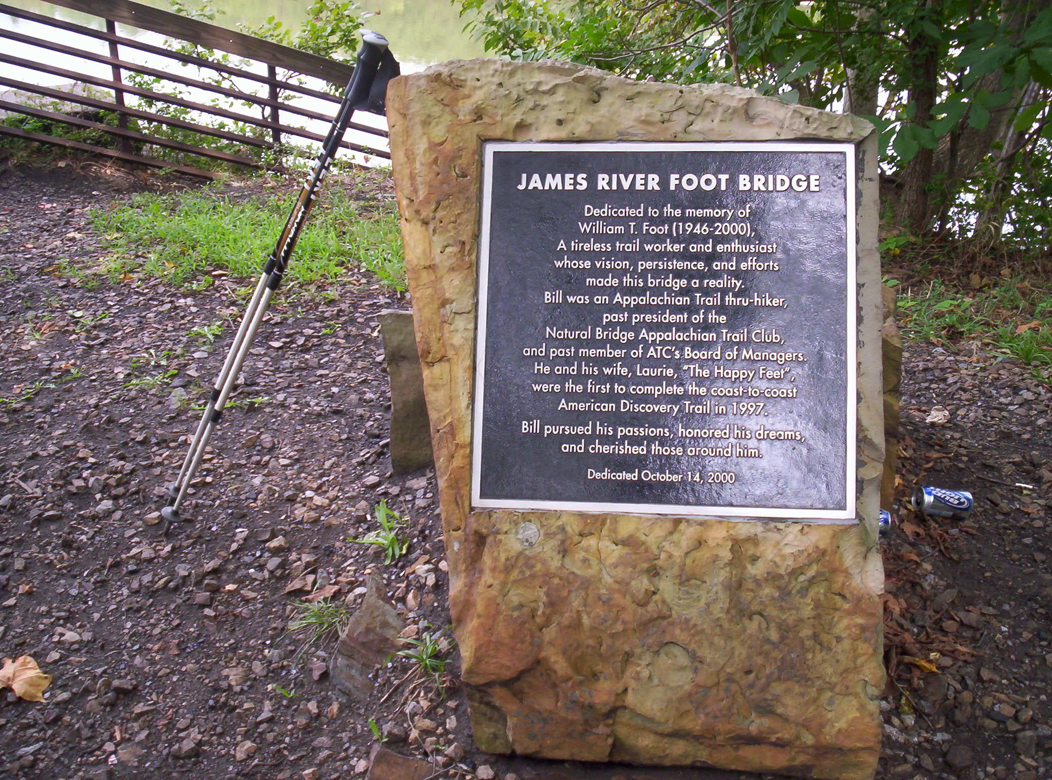
Fooded up from lunch, I head on again. It’s only a mile and a half or so to the James River, where I catch up to the Honeymooners. They’ve hitchhiked into town and eaten and resupplied, all in the ponderous time it took lazy me to get here. I definitely could make better time out here if I put some effort into it. But where would be the fun? Why restrict myself to a schedule of when and how long to hike each day, just to go a little further, a little faster? I pass them by and head across the James River Footbridge, the longest foot-travel-only bridge on the trail.
Dedicated to William Foot, one of the first thru-hikers of the coast-to-coast American Discovery Trail
You can get a feel for the size of the bridge from this picture, which going from overhead views appears to be just over six hundred feet long. I understand the pilings were already there before the bridge was constructed, but even still, I have no idea how this bridge ever managed to get funding. I suspect I largely have my American readers’ knowing and gracious generosity (wink wink, nudge nudge, say no more!) to thank for this:
One of my better-structured pictures from the entire hike, I think, save for being slightly too zoomed-in
How did hikers travel this section prior to installation of the bridge? It looks like if you head around half a mile east you’ll hit U.S. 501, which travels south over the river, and which hikers could cross, then travel the same distance back along the river to reach the spot where the current footbridge’s south end is. Tedious and boring (and depending on the condition of the crossing, plausibly dangerous), and I can certainly see why you’d want something else instead, but I can’t help think that, for the number of people who go across it and for the appreciation of it they have, it wasn’t worth the costs as they were likely apportioned. (Subsequent searching reveals a brief overview of the bridge’s genesis which suggests that the bridge owes its existence to a few hundred thousand dollars in donations plus several times more state funding. It looks like the creators were moderately successful at funding it in non-coercive ways, which is a small comfort — plus it seems Virginia properly took on the cost of its own project, rather than trying to live off the federal dole.)
Now being in front of the Honeymooners spurs me to hike more quickly, and I keep a brisk pace to Matts Creek Shelter. I stop and say hi to the guy already there and write something in the register. This register also contains the most brilliant combination of an entry from Thought Criminal (first noted in registers back in mid-Vermont) and a couple responses (a postscript in the first photo, an unknown person’s side note in the other). Beware: Authentic Marxist Gibberish ahead! 😀
Thought Criminal: "May 30, 1984. Thought Criminal pitching my Duermo Baggie Transnational Corporation sweatshop factory labor produced Casa de Silnylon next to the creek for the night." Red: "ps. I love my Duermo Baggie"
A further note: Duermo Baggie ("sleeping bag" in Spanish) as such doesn't exist according to Google, so I'm not sure how to interpret his rant against it.
A followup entry by Thought Criminal:
"May 30, 1984 - More advertising pitching for DuermoBaggie from Thought Criminal. For each DuermoBaggie Casa de Silnylon tenting domicile you purchase, a portion of the purchase price will trickle down to enable a Mexican family of 12 to subsist on a diet of the finest plain oatmeal for one breakfast meal. DuermoBaggie Transnational Corporation is also proud to pronounce that we have a very progressive retirement* program. DuermoBaggie sweatshop laborers retire by the age of 15 (* no benefits). DuermoBaggie's full line of products will be coming soon to a Dollar General store near you. DuermoBaggie is the 73rd name in fine Mexican-American outdoor adventure equipment. At DuermoBaggie Transnational Corporation, we aspire to achieve adequacy."
Someone else has written "AUTHENTIC MARXIST GIBBERISH" with an arrow pointing at the entry.
I move along just as the Honeymooners catch up to me, as I keep ahead of them for a little bit longer, but they catch up when I stop a couple miles south to refill water bottles from a small stream the trail crosses. From here we hike the next several miles together, following and curving along the ridges in the area. My mental distance counting notes that some of the claimed mileages near here are wrong, with the mistake being, as I recall it, that two segments’ distances are transposed. No worries — and it should have since been fixed in more recent Companions (whether by my notes at the 2009 Trail Days or prior to that, I don’t remember).
The view of a valley the trail curves around; the trail heads south to the left
A view further left of the valley, looking closer to the direction I'm heading
Shortly after this we reach Marble Spring, site of a spring and a campsite. It’s around 17:15 now, and we’ve hiked a solid 18.2 miles, so the Honeymooners stop for the day. There’s still plenty of daylight for me to get to Thunder Hill Shelter without hiking in too much darkness, which puts me that much closer to the people ahead of me that I’m attempting to catch (most immediately Grettle, Mango, Cubby, Spoon, and Santana), and on pace to make Daleville at a reasonable time, so I continue on after refilling on water.
The hiking goes ever so slightly more slowly now that I have no pace car to follow, but I still make good time. I pass by another apparent mileage anomaly, making two in the space of one day (in the space of several hours, even) — very strange. It’s getting later into fall, so I’m now starting to race against dusk when I hike past 19:30 or so, as this picture from Thunder Ridge Overlook demonstrates:
Definitely one of my hike's best pictures, top five or so for sure
I’m only 1.4 miles from the shelter now, and as you can see darkness threatens, so I keep up a good pace to make it the rest of the way. Ten minutes or so before reaching the shelter I hear a crashing noise (in nighttime-level darkness) off to my right, which puts me on my guard for the possibility of there being active bears in the area. A short bit of hiking later finds me at the shelter, where I eat dinner and head to sleep in short order. Twenty-five miles: definitely a good day’s hike despite a somewhat slow start, and progress consistent with making Daleville in two days.
September 17
(23.6; 1441.2 total, 732.8 to go; +8.6 from pace, -73.8 overall)
I get a decent start today out of the shelter, leaving a little after eight. The morning is cool and slightly foggy and cloudy, if memory serves, as I head underneath The Guillotine toward Apple Orchard Mountain.
Off with his head!
The mountain isn’t much of a mountain, but it’s still the highest point between Chestnut Knob, roughly two hundred miles south, and Moosilauke, slightly over 1000 miles north. There’s an old Air Force radar base atop it with a distinctive spherical radar dome, surrounded by fences with no-trespassing warnings, but otherwise there wasn’t much to see, so I kept moving along to Cornelius Creek Shelter, where I stop for a second to eat. The shelter’s reading material includes an Appalachian Trail guide from around 1992, and I crack it open to see how similar the trail and side features along the way were then to now. Running a hostel is a labor of love, and to be completely honest I’m not sure how one can actually make money on it, so it’s unsurprising that there’s a lot of changes on that front. I continue south to Bryant Ridge Shelter, perhaps the most architecturally significant shelter on the entire trail: it literally has three stories. The Companion suggests it sleeps 20; it could sleep many more if necessary (more still if people moved onto the lowermost floor’s porches, rather than restricting themselves to the “living” areas).
While I’m at the shelter, a hiker walks up, coming from the north. It turns out to be Cubby, another southbounder, who’s been ahead of me since the beginning of the trail, whom I now seem to have finally caught up with. He’s walking with little more than a day pack (possibly not even that), slackpacking south for the day, along with the rest of a group that’s been hiking together for, as I remember it, a bit under a thousand miles at this point: Grettle, Mango, Spoon, and Santana constitute the remaining members. Santana arrives as we sit, and Spoon follows shortly. Cubby and Santana depart shortly, as do I, but since neither is wearing a backpack I find myself unable to keep up with them without excessive effort. Spoon, on the other hand, is wearing a slightly more loaded day pack and has a pace just slightly faster than mine would be if I were hiking alone. The result is that I make excellent time as I hike with him the next ten miles or so to the road where he and the others are being picked up for the day. Along the way I get an update on current events: Lehman going under and the ensuing mass financial hysteria. When we eventually reach the road (I meet Grettle and Mango there, as they arranged the ride to pick the others up), I’m left with much to think about, if not much detail about which to really, deeply consider matters. The excellent pace of the last few hours means that I still have a good deal of daylight in which to hike to Bobblets Gap Shelter. Were I an hour earlier I’d probably even consider moving beyond that, but as it is dusk makes that unpalatable.
The southern side of this sign does not have any misspellings, in case you were wondering
After I fill up on water from the creek just the other side of the road, I head along to the shelter, arriving around 18:15. It’s comfortably evening, but there’s plenty of daylight and time to eat (my meal for the night is potatoes with bacon bits, a fact I take pains to note after seeing Flashdance’s entry express a hunger for bacon) and read awhile before heading to sleep. I still have no idea what I’m going to do about Daleville, but if I push it I can make Daleville, resupply, and be on my way to the shelter after if nothing pans out.
September 18
(18.5; 1459.7 total, 714.3 to go; +3.5 from pace, -70.3 overall)
I wake up early to head out and start hiking…or rather, I’m woken up early. Unexpectedly, out of nowhere, comes Medicine Man for an early-morning stop, and shortly behind follows Smoothie. Hmm…this could be the answer to where to stay tonight! Medicine Man remarks that I must have sped…up, in order for him to have seen me again (he’s still hiking, stopping off-trail for a bit, then continuing again). I quickly pack up, pop a Pop-Tart, and head south with them.
Hiking goes well today; we tend to take a break about every hour or so, with fast-paced hiking in between. My pace now seems to be almost the same as Medicine Man’s on flat terrain. Heading uphill he moves noticeably faster than either Smoothie or I do; downhill we make up what we lost to him on the uphills. We stop at Wilson Creek Shelter and regroup as Cubby, Spoon, Santana, and the rest of that group also pass by, then again at Fullhardt Knob Shelter a handful of miles out of Daleville. The shelter has a unique water source based on retaining runoff from the roof in a well. I skim the register and make some offhand comments about entries, including one by the Four Sisters, and someone else says they didn’t complete the trail — and even stranger, they decided this halfway into the 100 Mile Wilderness after hitting a lot of rainy weather. It’s true there were also college deadlines in play, making it necessary to keep an accelerated pace to finish — but still, I can’t imagine what would possess someone to walk 2100 miles and then give up with only 75 to go. (I hear they did have plans to reunite to finish out the trail in summer 2009, but I don’t know whether or not it actually happened.)
We arrive in Daleville by early afternoon, Smoothie and I slightly ahead of Medicine Man because the last five miles from the shelter include more downhill than flatland or uphill. The three of us split a room at the Howard Johnson’s just a few hundred feet down the road the trail crosses in Daleville. Since it’s still fairly early in the afternoon there’s lots of time to relax. I get a shower, laze around a little, resupply on groceries, head across the street to a Mexican restaurant for dinner, and return in time to catch a college football game Medicine Man in particular is intent on watching. A good day all around…
Thirty-seven days, just under a third of the trail’s mileage to go…
(25.9; 1067.0 total, 1107.0 to go; +10.9 from pace, -163.0 overall)
The restaurant across the street, Goodie’s, may open early, but I’m not in the mood to get an early start today, particularly with the sprinkly rain outside. Instead I sleep in a bit before picking up groceries and eating at the restaurant. While there I skim through the newspaper, discovering that Obama gave his nominee speech within the last couple days, finally becoming more than the presumptive nominee at the Kabuki dance that is a modern political party’s national convention.
In more interesting, less ceremonial news, I read through an article discussing the Amethyst Initiative: but first, a little background.
It is well-known that the national drinking age in the United States is 21; I will presume without evidence, however, that it is far less known that this is untrue. In reality there is no national drinking age in the United States. Rather, each and every state has determined its own drinking age to be 21. Independent determinations by the states? Evidence of settled scientific investigation? Lobbying by the Sons of the Women’s Christian Temperance Union? None of these reasons are accurate. (Okay, I haven’t really checked that the last possibility didn’t happen; I’ll bet a beer that it didn’t.)
The reason the states have universally adopted a drinking age of 21 is that Congress extorts the states to make 21 the minimum lower bound on the drinking age. In 1984 Congress passed the National Minimum Drinking Age Act, pursuant to which:
The Secretary shall withhold 10 per centum of the amount required to be apportioned to any State under each of sections 104 (b)(1), 104 (b)(3), and 104 (b)(4) of this title on the first day of each fiscal year after the second fiscal year beginning after September 30, 1985, in which the purchase or public possession in such State of any alcoholic beverage by a person who is less than twenty-one years of age is lawful.
23 U. S. C. §158. In plain English any state which has a drinking age under 21 loses 10% of its federal highway funds. Keep the limit at 21 or higher and you get all the money; lower it below that and you lose 10% of it. Congress did not have authority to pass a national drinking age directly (a plausibly-disputable assertion if one looks to Supreme Court precedents rather than to the Constitution itself, but suffice it to say that if Congress could duck the battle it would), so it instead brought about the same end result by coercing the states into doing it on their own; it made them an offer they couldn’t refuse. (This isn’t strictly what happened; a few states held out on immediately modifying their drinking ages, but all eventually caved. Also, Puerto Rico and the Virgin Islands, while not states, are apparently subject to the withholding, but both have a drinking age of 18 and apparently forego that 10% of funds as a result.) Smarmy, eh? This is the reason why, if you desire to see the drinking age changed, you’ll almost certainly have to make a national campaign of it rather than simply a statewide campaign.
Of course, the act raised serious constitutional questions with respect to the Tenth Amendment and the Twenty-First Amendment (the latter being dragged in, perhaps, because its language might plausibly constitute a grant of extra powers to the states). Does the federal government have the power to, to some extent, under certain interpretations of the proposed legislation, enact legislation outside the scope of its constitutionally-enumerated powers through coercion? It’s not a simple question, and it went to the Supreme Court in South Dakota v. Dole. (Also consider that there are other flavors of the question. For example, are fund grants conditioned on use in a specific manner fine, e.g. a fund grant for state police to use for anti-terrorist training? That hypothetical might seem much more reasonable, but how does it differ from the other scenario? Nailing down specific distinguishing factors is never easy, and there are many which might be reasonable to consider.) What’s the right answer to the question? I very much know what I want the answer to be with respect to the particulars of this situation: extorting the states this way is downright smarmy. Of course that doesn’t mean it’s constitutionally impermissible. There are many potential regulations which, properly examined, would be both constitutional and utterly abhorrent. I once thought the case was (unfortunately) correctly decided, but the more I read the less I believe I know enough to answer the question. It’s a research topic I’m going to have to investigate sometime, but here might be one potential starting point, from McCulloch v. Maryland, 17 U. S. 316, 423 (1819):
Should Congress, in the execution of its powers, adopt measures which are prohibited by the Constitution, or should Congress, under the pretext of executing its powers, pass laws for the accomplishment of objects not intrusted to the Government, it would become the painful duty of this tribunal, should a case requiring such a decision come before it, to say that such an act was not the law of the land.
(Hmm, I seem to have forgotten to return to the Amethyst Initiative, haven’t I? Basically, its goal is to start a dialog over whether the current “national” age limit is the best way to achieve the ostensible goal of the legislation: to keep “youthful” minds, and the people around them, safer. It doesn’t advocate a particular solution, but it recognizes that the current national age limit just doesn’t work: it’s too easy to get and consume alcohol if you’re underage. My thoughts on it are roughly these. First: I might have personally benefited from it, insofar as I might have been able to legally drink starting at an earlier age. Given my habits I’m sure the restriction would have made no difference in my safety, or that of others, because I’ve always been careful — not so much out of concern as out of proper enjoyment of the taste. Such enjoyment requires a very slow pace of consumption; it is at least plausible that if I drank at a normal pace, it would be impossible for me to make myself drunk. Further, since I stop after at most two or three glasses, I don’t think there’s much danger of my somehow losing self-control and unintentionally drinking faster. Moreover, I drink somewhat fitfully — usually a bottle or two of wine-equivalent a month. [And that’s now that I’m on a steady income; given my spending habits I have great difficulty believing I’d have consumed even that much in college if it were legal to do so.] Further throw in that I don’t own a car and either walk or bike now and in college, over short distances, and the overall danger from me seems negligible compared to the utility of occasionally being able to enjoy a drink. Second: this analysis probably doesn’t apply to very many people, unfortunately. Third: the legal prohibition now really isn’t, it’s wink wink, nudge nudge, say no more. Overall: Changing the current laws would have been an unqualified good for me. It would have also been good, and worse, for others. Given the failure of the current system, both practically and for lack of will to truly enforce it, and the good it prevents for those who are responsible, I think I would be in favor of loosening current restrictions at least to a point where the limit, at the very least for the “well-behaved” by some sort of legal evaluation, is 18. Harsher penalties for 18-20 when problems occur where alcohol is a factor would be fine, perhaps even recommended. It also comes down at least a little to Twenty-Sixth Amendment-style concerns: old enough to be in the army, old enough to vote, old enough to drink. Try reading about the experiences of Vietnam veterans during the war and upon return to America afterward; it’s pretty patently absurd.)
But anyway. With breakfast finished I head back across the street to the Doyle, where I pack up my things and leave minutes before checkout time at 11, saying good-bye to Silver Potato and Cracker and the Honeymooners on the way out. It’s still a little rainy, and neither couple feels like walking in rain. It’s somewhat tempting to stay longer, but I’m not in the right mental state to stop and drop an entire day here right now, particularly since it hasn’t been that much longer than a week since my last zero. Most other people take many more zeroes than I do, probably more than I could really bring myself to take even if I had no constraints on my time; I make up for it by taking longer, more frequent breaks when I’m hiking (hence why most stops at shelters are closer to an hour than to a couple minutes).
From here it’s a short bit of walking through the rest of the town before it’s back up on the ridges again. It’s not much of a walk to get to Cove Mountain Shelter, where I stop briefly to read the register and write a note in it recommending the jambalaya at the Doyle. The shelter has gnawed-smooth boards along the length of its porch, where a person might sit and let legs dangle; it’s clearly a prime spot for porcupines looking for salt to lick up from where sweaty hikers have sat.
Much of today’s hiking is uneventful. I make good time by not stopping much; after Cove Mountain it’s 7.3 miles to the next one with only a single road crossing for distance-estimation. The rain does stop eventually, but things stay generally pretty wet, and I can start to feel my feet rubbing against wet socks in a somewhat unpleasant way. The next shelter, Darlington Shelter, again has a register, and for the first time I see in it an advertisement for the Harpers Ferry Hostel that isn’t premature! Harpers Ferry is perhaps 110 miles south of here, which is a week or so south at a decent clip. It’s close enough now that one could imagine stopping once between here and there for food, then stopping in Harpers Ferry for a night — the key here being that it’s close enough to plan your next stop from here so that you’d reach Harpers Ferry at exactly the right time to stop. I’d have been fine seeing this ad as much as fifty or sixty miles back, too, but that first ad I saw for it perhaps 800 miles back, and all the others I’ve seen between there and here, are just too much.
I’ve gone 11.3 miles so far today at a reasonable clip, but from here south the trail becomes somewhat inhospitable as I pass through the Cumberland Valley. The valley is almost entirely covered with roads and large expanses of farmland, and there’s basically no cover anywhere. In fact camping is actually prohibited from Darlington south for 18.2 miles, except at a single place: Boiling Springs at 14.6 miles south, my target for the day if I don’t stop here (and there’s no way I’m doing that, not this short a day — were I to stop, I might as well have stayed in Duncannon). Back to the trail I go, heading south across the foggy valley.
A foggy day above Cumberland Valley
The valley is definitely a change of pace from the usual ridge hiking to which I’ve become accustomed. Is it a good change? It’s really just a change. Many fewer people would hike the A.T. if it were like this the entire way; on the other hand, the A.T. really isn’t a trail of the wilderness. Anyone who hikes it now is never more than a few days from roads that head toward a grocery store or a place to stay off-trail; days of solitude are possible but uncommon. As one hiker grousedremarked in the register in Cable Gap Shelter in Georgia, no matter where you go you never have to wait long to hear an airplane passing nearby. Day hikers and weekend backpackers are common. The trail isn’t a hike outside of civilization, it’s a hike that skirts or runs amidst it. Today’s valley walk is, all things considered, par for the course — less wild than most parts but not at all unusual except in its sheer length.
Shortly after leaving the shelter I pass by the trailhead for the Tuscarora Trail, a side trail off the A.T. created years back when it was unclear that the official A.T. would remain fully accessible due to its passing over privately-owned land. The A.T. did eventually succeed with its occupied route, but the Tuscarora yet remains as an alternate path to travel between here and its southern end 185 miles south in Shenandoah National Park (if, admittedly, a less maintained path than the A.T. — we’re spoiled). A couple miles further on I pass by what is now the first underpass on the trail, going underneath Pa. 944. Construction finished up just over three months after I passed, so I wasn’t able to use it, but it was substantially excavated at that point. Crossing the road made it abundantly clear why the underpass was being installed: fast-moving traffic and low visibility in both directions due to a hill in one direction and a curve in the road in the other. At the moment this street view of the area shows the now-past construction, as well as overall visibility (traffic speed makes it worse than it might look):
The A.T. crossing of Pa. 944, which became a functional underpass a few months after I passed by
A couple miles past that I hit an ATC work center, an organizing point for, I presume, work trips. I don’t stop for long, but the late start and my breaks today mean it’s past 18:00 by the time I leave to head south again, and I still have 10.6 miles of hiking until I can camp legally. I foresee night hiking in my immediate future; good times.
The rest of the day’s hiking proceeds uneventfully, the last couple hours or so of it in darkness. Once after dark I see what I think is a skunk twenty feet or so up the trail; it turns around and heads the other way down the trail as I (cautiously) follow it. By the time I reach Boiling Springs it’s approaching 22:00; ideally I’d have arrived earlier and gotten something to eat in town, but now it’s late enough that I don’t really feel like walking a couple tenths of a mile off-trail and finding out they’re closed or effectively so. Boiling Springs has an ATC office at which I fill up water bottles from an outside spigot the Companion mentioned, but otherwise I’m in and out of town without stopping, a few tenths of a mile south past some train tracks to a small field with an outhouse (present Memorial Day to Labor Day, so I’m just in under the wire!) where camping’s permitted. The Companion warns that, “The trains do run past here all night long”, and for a moment I’m not sure what it means, until a train passes by. This field is right next to the tracks, and that train’s loud. Here’s hoping I can sleep well with this racket…
August 30
(19.1; 1086.1 total, 1087.9 to go; +4.1 from pace, -158.9 overall)
I’d sort of intended to wake up semi-early to get into town to eat a full meal, but when push comes to shove in the morning I choose sleep over food. Rather, I try to; I must have slept through many trains throughout the night, but the ones passing by this morning are all more than loud enough to prevent me from really enjoying those extra minutes of rest. My feet, which felt a bit waterlogged yesterday and prone to blistering, are feeling about the same today, and my socks didn’t dry out enough overnight to really help matters. None of this bodes well for attempting the Four State Challenge when I reach the border in a few days or so. Still, that’s awhile off; we’ll see what happens before then.
Today’s hiking passes mostly in a blur. My feet continue to be red and irritated all day from excess moisture, but hiking goes reasonably, if slowly. After 10.5 miles, however, it’s time to stop — for ice cream! I’m within spitting distance of the halfway point on the trail, which means it’s time for the Half Gallon Challenge, a thru-hiker tradition involving ice cream whose name explains itself. I get a deli sandwich, a half gallon of ice cream, and a pop before moving on. It’s fairly late in the afternoon, but I know I’m not going to make it to Pine Grove Furnace State Park, my goal for the day, in time to visit the store there to complete the challenge, at least not if I don’t want to wait around until opening time tomorrow. Now a half gallon really isn’t a challenge for me, and I’ve eaten several so far on the trail, but today I make the mistake of eating my sandwich before eating the ice cream, with the result that I’m stuffed way before the ice cream is gone. I eat about two-thirds of it before deciding, regretfully, that I can’t finish it if I’m going to make it to Pine Grove before it gets too dark — an important concern because I’m staying at a hostel by the park, not camping near the trail, and it does have particular hours. As I head back to the trail I notice a newspaper stand, glance at it and walk the other direction, then do a double take: McCain picked who to be his vice presidential candidate? Wow. I’d heard Palin mentioned as a plausible choice but only as a dark horse pick. This could get really interesting, really fast.
The remaining ten miles pass quickly as I finally start to hit a good pace. A mile or so before the park I pass by the trail’s halfway marker:
The A.T. halfway marker
The marker has been here for several years; it’s not really the halfway point now — the exact point changes from year to year with trail relocations and adjustments — but it’s only a handful of miles off. It’s close to 20:00 now, so I snap a few pictures (all of which turn out about as well as this one, except that this one had the best aim) and hurry on. The park technically closes at dark, so I’m going to be pushing it when I get in. Twenty minutes later or so I reach the park and, after a little stumbling around, find the hostel. The building was part of the Underground Railroad at one time, and it has a hidden basement where passengers would hide — reminds me of some of the spaces above ceilings and between floors in buildings at MIT. (Or so others tell me.) The hostel currently lacks laundry detergent, so it looks like I’m not going to be getting fully clean tonight. I still take a shower and hop into clean clothes for the night, after which I call home, catch up on email and read a few news articles, and head to sleep for the night.
August 31
(17.3; 1103.4 total, 1070.6 to go; +2.3 from pace, -156.6 overall)
It’s up and out this morning after too little sleep, but down the trail I go again. Hiking goes slowly as I pass the current midpoint of the A.T. somewhere a couple miles south of the hostel; I keep feeling like I should stop and doze off for a bit, which I eventually do for an hour or so — it helps. (However, the nap doesn’t do anything for my feet, which are still a bit raw and blister-prone but not so bad that I’m going to consider extra rest.) I’m in better shape after that and start making good time heading south, passing by Tom’s Run Shelter shortly after. I stop to read registers (there are two of them, because this shelter is actually two — each maybe eight feet by eight feet, separated by maybe fifty feet or so) and watch a butterfly move around and fly onto my backpack for a bit. I take several pictures in order to get it mid-flap with its full colors showing; it’s just fast enough and my camera is just slow enough to make this tricky:
A butterfly in mid-flap; the timing was actually kind of hard to pull off with my camera
I write an entry with some minor election commentary now that I’m caught up on world events, something snarky as I recall, before heading on again. After some uneventful walking I stop again at Birch Run Shelter for a break, just short of ten miles into the day; the shelter here is ridiculous. Imagine a small one-room log cabin, move one of the walls inward far enough to comfortably fit a picnic table, cut a door opening in that wall, then fill the inside with bunk space for eight people (more if people sleep on the floor, and more if you add in the porch). The wood all appears recently treated with polyurethane and other niceties; it’s nothing like most other shelters where the wood is treated, maybe painted, and hauled out to install. I’m now into Potomac Appalachian Trail Club territory, and the shelters here are either insanely awesome or fairly old but well-designed and amazingly well-maintained. It’s good enough that I’ve occasionally heard murmurings from other people that the club is too well-funded — an enviable position to be in, I’m sure. I stop long enough to write an entry in the register, but I need to keep moving both because it’s too early to stop and because it’s clear this shelter and the surrounding camping area are going to be very crowded tonight (there are nearly a dozen people here already, and there are still a few hours left of daylight for hiking).
The rest of the day’s hiking proceeds quickly and purposefully as I keep moving to ensure I have a reasonable amount of daylight at its end. It’s also worth noting that an early arrival means more time to sleep tonight. If I’m to attempt the Four State Challenge I really want to be as rested as possible the day before it, which means I get a lot of sleep tonight, finish the remaining twenty-odd miles to the Pennsylvania-Maryland border tomorrow as quickly as possible, eat a good dinner, and head to sleep. It’s a long walk, and I’m going to aim to be up sometime in the first three hours of the day — ugh — so I can keep to a comfortable pace and so I can visit the ATC office for the traditional mid-hike photo. I arrive in a fair amount of daylight, although the sun is mostly hidden at this point. Quarry Gap Shelters are another crazy spot: two small concrete log-cabin-styled shelters, with a concrete pad between them and a picnic table on it for cooking (and even a tarp that can be hung across the back to break the wind). A pocket on the trail-north shelter’s wall even contains board games for people to play! It’s an old shelter, dating to 1935, but it feels amazingly new and amazingly awesome. The PATC really does have too much time and money on its hands. 😉
This shelter’s not as crowded as Birch Run was, but it’s pretty full. I’m the only thru-hiker, but there are other backpackers and a family there too. The backpackers are two middle-aged-ish women from Massachusetts or Connecticut (and the AMC; they tell me they thru-hiked the A.T. years ago and are just out doing a short trip now. I mention I’m going to attempt the Four State Challenge when they ask about my plans; they say they did it at a much more leisurely pace, perhaps not even breaking twenty miles in a day (and definitely any day even approaching that was a long, restless, painful day). I take advantage of their presence to complain about the lack of signage at the MA–CT border and show my pictures of what I thought was the border. It turns out the bark removal wasn’t supposed to have happened, but they do say the border is intentionally not marked well to discourage campfires just over the border into Connecticut (which forbids campfires at least on the A.T.), close enough that their prohibition doesn’t have much meaning if you can pinpoint the border and put your fire a few feet over it. They attempt to rationalize the campfire prohibition in various ways, but I remain thoroughly unconvinced. So the ground becomes sterile — so what? If you limit it to established campsites and rings only, you’re having the fires in places which have a fairly permanent impact on the area already! A little more at the edge of a well-established existing site would concentrate the impact in one location (a key principle of Leave No Trace). If you limit to rings only, that greatly minimizes the danger of a fire spreading out of control onto neighboring (private) land. Finally, campfires are an intrinsic part of camping. They may be a bit harsh on a few square yards of land (and to a lesser extent on the surrounding couple acres for dead limbs for fuel, but the relevant areas are forested and fuel would be plentiful), but that doesn’t mean the only proper response is a draconian ban on them entirely. Sigh; I’m glad I don’t live near Connecticut trail, even if I never started a campfire while thru-hiking and have difficulty even imagining a situation on the trail where I might.
Kids from a family staying for the night are rather loud, and one of the women has to yell over to the other shelter to ask for quiet, but I read late enough that I don’t have a problem with noise or getting to sleep. It’s 20.5 miles to the border plus whatever I need to do a little bit of resupply: I’m running low on food and snacks, and I want enough to get to Bear’s Den Hostel, which is a dozen miles after the Four State Challenge ends. I plan to do most of that tomorrow to get as close as possible to the border so the most epic day of backpacking I’ve ever considered doesn’t have extra mileage tacked on at the beginning rather than the end. We’ll see what happens and how easy or hard it actually ends up being…
September 1
(19.9; 1123.3 total, 1050.7 to go; +4.9 from pace, -151.7 overall)
Labor Day!
I’ve been a little worried about today being Labor Day, what with my plan to attempt the Four State Challenge tomorrow, as I don’t have the supplies to do it without visiting a grocery store. Will I be able to find a grocery store open today, at the time I reach it? Probably, since Labor Day isn’t one of the huge-name holidays, but it’s still a potential wrinkle, and given that I’m twenty miles from the border I don’t have a lot of margin for error. It’s not far from the shelter to Caledonia State Park, which presumably will have a ranger or two around to ask, so at least I’ll be able to find out early enough in the day to go further out of my way if necessary. I’m betting the store 0.7 miles west of the park will be open, but you never know.
It’s not much of a walk to get to the park, which is full of people picnicking and enjoying the day. A few people at a picnic table say hi and ask about my hiking plans. They tell me they’re from the nearby Waynesboro Senior Center, out for the holiday, and I answer some of their questions in return. They also offer me some of their food, which is mostly standard picnic fare with perhaps a little tilt towards sweets; I eat a couple doughnuts, some fruit salad, and a couple sandwiches made from the fixings they have, and they give me a doughnut or two “for the road”, as it were. They’re very oversupplied for the number of people they have, and they’re more than happy to see it be put to good use. I dally for a good length of time before deciding I really do have to move on, as I have 17 miles or so to get close to the border today and not much time after that to get some sleep before a long day with night hiking to start it. A brief search takes me to the park headquarters, where a ranger confirms that the store down the road is indeed open (although perhaps with slightly curtailed hours, not a problem for me), so I head off to it and resupply. I spend a little time at the store eating the remaining doughnuts and getting a little food and water in me before walking back to the trail to head south again.
The next few miles on the trail pass slowly. I didn’t get very much in the way of supplies since I only need it for a couple days, so it’s really just my normal early-day hiking funk. Some people hike strong in the morning and early part of the day; I’m just the opposite. I stop for a second by the trail to Rocky Mountain Shelters to polish off the rest of a loaf of raisin bread I bought at the store, hoping that maybe a little more delay and a little more energy will help me move faster. It doesn’t, but maybe a mile south I reach something that does — or rather, that something reaches me: the Honeymooners again! There’s nothing like putting someone in front of you on the trail to motivate you to keep hiking — kind of like the mechanical rabbits in dog races. The miles start flying now; we pass by Tumbling Run Shelters without a stop, heading toward Antietam Shelter. I stop at a road crossing to refill on water from a nearby stream, since it sounds like Antietam’s water is off-trail slightly, and continue on working to catch up to the Honeymooners. I do, eventually, at Antietam, where I discover they’re stopping for the day. Deer Lick Shelters aren’t much further down the trail, and they can be reached before dark, but they’re stopping earlier (and why not, since they’re probably at twenty miles for the day now anyway). I mention my intent to complete the Four State Challenge, and they wish me luck. Jessica cringes in horror at the idea, enough that it’s clear it was never in their plans even as a possibility. 🙂
A short bit more hiking takes me to Deer Lick Shelters, the last shelter(s) in Pennsylvania and the last paired shelter I remember on the trail. It’s possible I just missed ones further south, but I’m guessing this is some sort of weird Pennsylvania thing. I stop, mention my plans in the register (I hardly expect to spend time doing so in any of the shelters in Maryland tomorrow), and move on. The remaining miles go well as I race dusk to get close enough to the border to stop. Eventually, at what I estimate is about half a mile short of the border, I cross a stream where I refill water bottles and find a small spot that appears perfect for campfires (although I see no burned material to indicate it’s been used as such recently), just as it gets dark. I don’t need much tonight beyond a somewhat comfy place to use a bivy sack, especially since I plan to wake up no more than a couple hours after midnight (!) to start the day’s hiking, and it’ll do fine. Two Knorr dinners later (I figure I need the energy, and it won’t hurt to reduce pack weight a little), it’s off to sleep, I believe after 22:00 — so much for finishing quickly and getting lots of rest before tomorrow. I set my watch alarm for 00:45, put it right next to my head, and pray that I’ll actually wake up to it. Too tired…
September 2
(51.0; 1174.3 total, 999.7 to go; +36.0 from pace, -115.7 overall)
I wake up on time to my alarm, thankfully, and mentally I’m in the right state to not unthinkingly roll over and back to sleep. It is so very tempting to rationally decide to sleep some more — but I could never forgive myself if I didn’t even make an attempt to complete the Four State Challenge the one chance I’ll probably ever have to try. I get up, pack up my sleeping bag and bivy sack, polish off a Pop-Tart, and start hiking south. It’s 1:15, and I am officially insane to be doing this.
I’m still in Pennsylvania now, but not for long — it’s only 0.6 miles to the Mason-Dixon line traditionally dividing South from North and officially dividing Pennsylvania from Maryland. Goodbye and good riddance to Pennsylvania and the Pennsylvania Rocks! I like to see something at a state border, and while what’s here isn’t much, at least there’s something:
The Mason-Dixon line marker
The marker’s clearly seen better days, but it’s there and visible: I know exactly where it is and where I am in relation to it. From what I understand it was vandalized even worse shortly after I passed it (assuming my understanding of the description I received doesn’t simply describe the state in the picture), to the point where it wasn’t even there, so I’m glad I got there when there was something to see and note my progress. Shortly after I reach Pen Mar County Park, where I had intended to drop off my meager trash but promptly forget to do so now. There’s a nice view off over the surrounding countryside and its nighttime lights, but I move on without stopping very long.
Shortly after this I discover that the Pennsylvania Rocks! don’t end when you leave Pennsylvania; they actually continue down through much of Maryland, more or less petering out shortly into Virginia. On the plus side, I have to take a nice, relaxing pace over them to avoid stupid injuries, so it’s sort of a nice warmup for the day, since when it’s light I’ll need to keep a consistently good pace if I want to make the ATC office before it closes. Shortly after I discover that, oddly, I’m not the only person out and about now, as I pass a guy camping by a campfire, still awake, who’s awake enough to ask me questions when he sees me coming. This is more than a bit puzzling. First, overnight camping is allowed only at designated sites, so what’s he doing just off the trail here? Second, a campfire, at 2:00? Really? Really?
The trail moves along from here reasonably well. I pass a shelter, stop for water at a small stream I have to cross in a section of trail marked as somewhat fragile due to it passing near a watershed used for drinking water (or so I recall), and pass another shelter as darkness reigns at this early time in the morning. I hike through fields as dawn arrives, leaving a good half hour or so of change from nighttime darkness to visible light on the horizon. By 6:30 it’s bright enough to hike without my head lamp any more.
Now is when things start to get difficult. The trail is still rocky, but the sun’s coming out to make things much easier. Unfortunately, now is when lack of sleep starts to catch up to me, and for the next hour or so my pace is slow, and I don’t feel like I’m moving quickly enough. Moreover, it’s now perhaps 7:15, and I judge myself to be at about 1135 miles overall — but the ATC office that I have to reach by 17:00 is at about 1165 miles. My good pace is three miles an hour, but even if I hike at that pace constantly the rest of the way I wouldn’t make it in time. I feel an insistent temptation to drop the pack for a second, sit down, and lean back for a minute. However, I know this: the moment I do that, I can write off the Four State Challenge. In my current state it probably wouldn’t even take me a minute to fall asleep, and I don’t have the time to spare for a nap even if I could successfully limit myself to some particular duration. By sheer willpower I keep moving and keep hiking. I’ve thought about this since then, and I say this: choosing to keep moving at that point, fighting exhaustion and a seemingly unfeasible schedule, was the most difficult short-term decision I’ve ever made in my life.
Remember that saying, “Never judge a man until you’ve walked a day in his shoes”? (It’s actually “mile” rather than “day”, apparently, but the mangled version is what springs most readily to my mind.) I think if you want to judge me you will have to walk this day — all 51 miles of it, at the same pace I walked it, with the same stops I took. And you will feel pain, and you will feel exhaustion, and you will fight against instinct and against everything you know you want to do to achieve a goal that is of absolutely no intrinsic value whatsoever, and you will keep working towards this meaningless goal for no reason other than because you have chosen to do so. You will hate it, but you will keep doing it, and you would do it the same way if you had the chance to go back in time and do it differently. Then, and only then, can you judge me.
That decision marks a turning point for the entire day. If I’m going to keep moving, and if I’m going to make it to Harpers Ferry and the ATC office before it closes, I must speed up, so I do, probably to three miles an hour or so now. A little further I reach Pine Knob Shelter; I don’t really want to stop, but there’s an extremely convenient privy, so I head over just long enough to use it before moving on (not even visiting the shelter proper; I know what will happen if I stop at it just to look at the register for a second). Now’s when I really start picking up the pace as I pass over I-70, and I start easily making three-plus an hour. I’ve usually mentally kept track of upcoming landmarks in tenths of a mile to gauge progress; I stop doing that now and switch into full-out hiking mode. I pass by the Washington Monument (not that one) without stopping even long enough to see it; the closest I get are glancing at the illustrative signs on the trail up to it, as I head toward the parking lot of the park. I’m hoping to refill on water, but the faucets don’t seem to be running, so it’s keep-on-moving time. From now until Harpers Ferry, I hike almost without stopping, except that about every hour I reach behind me to pull out a large candy bar, snarf it down, pull out my Nalgene, stop only long enough to get a gulp of water without getting it all over myself, then start walking again as I close it up and put it back in place. I do make one exception for Dahlgren Backpack Campground which, bizarrely enough, has a restroom facility with showers (too bad I can’t stop for a night here to use them), both to refill on water and to dump the trash I forgot to dump at Pen Mar. Otherwise it’s continuous hiking, mile after mile, past views and shelters large and small, without stop except for swallows of water — not even for a lunch.
After many rocks and minor elevation changes of perhaps a thousand feet either way, I finally reach what was originally the C&O Canal Towpath, the last real milestone before Harpers Ferry. (The towpath is now a bike/hiking path chiefly due to a protest walk of it by William Douglas, the only Supreme Court Justice to walk the entire Appalachian Trail [in his case by a section-hike that concluded in 1958].) By now it’s somewhere around 15:30-16:00 or so, and with 3.5 miles remaining, and most of that on the flat towpath, I can tentatively assume victory in my attempt to reach the ATC office before it closes. Nevertheless I don’t slow my pace for fear that in doing so I will slow down too much and be unable to increase speed again, and in the end I reach the ATC office by about 16:35. By my estimation, since the turning point around 7:15 or so this morning, I have sustained an average pace of 3.6 miles, and I can feel every bit of that 0.6 miles an hour above the top pace I can comfortably sustain.
I thought I was the only southbounder ahead for a bit, but it turns out I’m not alone at the office — Smoothie is here! I haven’t seen him since Bald Mountain Brook Lean-To, just south of Monson — 1030 miles ago (!). We catch up for a bit — I find out that Colin, now known as Carat, whom I last saw at the same time I last saw Smoothie, unknowingly contracted — wait for it — dysentery. (I thought we were hiking the Appalachian Trail, not The Oregon Trail!) Apparently he went to a hospital three times before it was correctly diagnosed (the first two times they said it was just normal diarrhea, the third time apparently his liver was close to shutting down [!]), and now he’s way back on the trail from taking a couple weeks off from hiking. Smoothie and I aren’t sure how he managed to get it, since he was using Polar-PUR on his water as regularly as I’ve been using it. Speaking of water treatment, Smoothie hasn’t been treating quite so regularly, and he’s managed to get a bit of giardia (read: explosive diarrhea); it’s nothing antibiotics can’t treat, but the infection doesn’t just wear off immediately, so he’s stuck with it for awhile. I dash off a post noting my efforts for the day and try to catch up a little bit on email and such before heading south again. Smoothie heads into town to get something to eat, but it’s too far of a walk for me, so I leave the office later than he does but end up ahead of him on the trail.
From here, to technically complete the challenge, it’s apparently only 1.9 miles. The Companion’s descriptions and the way the trail lies make it a bit confusing, so where I thought I had 5.8 miles to the state line it’s really much less. Still, I’ve set out thinking otherwise, so I’m going to aim for 5.8 miles. Also, hey, why not? If I go only three miles past 5.8 miles I’ll hit the David Lesser Shelter, surely more comfortable than just sleeping some random spot off the trail. Plus, as a bonus, that’ll put me over fifty miles for the day. When will I ever come close to walking that far in a day again? I have to try for it. Meaningless goals: I strive for them. 🙂
I expected to be hiking more slowly after such a long break, not to mention after such over-exertion before, and I’m not disappointed, as my pace slows to two, maybe two and a half miles an hour. It slowly turns dark as I keep on hiking, and eventually it hits full nighttime. By 20:00 my hiking is more stumbling than walking; I’m sure anyone who could see me now would think I was drunk. The single line of What Do You Do With a Drunken Sailor that I know (hint: it starts with “what” and ends with “sailor”) plays in my mind as I walk. I pass the road that marks what I originally thought was the border — three miles to go! I continue stumbling south looking for the turnoff to the east that marks the shelter, watching an incredible number of deer standing in the woods watching me pass by. I can see them almost entirely by the reflections in their eyes; is my head lamp the physiological equivalent of headlights to them? At 22:15 I finally reach the shelter; I could walk further, but the next shelter is three miles away. 51 miles ought to be enough for anyone. (The funny thing is, if the next shelter didn’t have a caretaker I probably would have headed for it, to reach the equally empty goal of walking two marathons. 🙂 ) I’d hoped it would be empty, but it turns out there’s one other person, and when I see he’s awake I hastily apologize and say I’ll be asleep quickly and quietly. Indeed it is so — and thus ends the most epic day of backpacking ever. 51.0! +36.0!
This is the stupidest thing I’ve ever done in my entire life. 😀
September 3
(11.1; 1185.4 total, 988.6 to go; -3.9 from pace, -119.6 overall)
I am understandably in no rush to hike today, so I don’t set my watch alarm and I roll back over when I first wake up. The shelter’s empty; last night’s occupant must have left already (not surprisingly, given that it’s easily 9:30 or 10 by now). I pull out a Pop-Tart and eat it while reading through the register; I make my entry noting 51 miles yesterday (which I end with the sentence “RRRAAAWWRRRR!!!” [letter and symbol repetitions approximate]) and see Rock Layer’s entry noting his 60-mile day. It’s late morning by the time I head out, but it doesn’t matter: I’m not going any farther than Bears Den, a hostel and trail center just adjacent to the trail 11.1 miles south of here. Even if I take six or seven hours I’ll still be there well before 18:00, and even in my partially hobbled state I believe I can do better.
The first stop is a place that would have been a reasonable goal for yesterday if I had kept up my pace from before the ATC office or if I’d stopped for a shorter period of time: Blackburn Trail Center. It’s another PATC facility, and it has two buildings that serve as a summer caretaker’s home plus a smaller bunk house for hikers. The caretaker when I passed through apparently made spaghetti for hikers around dinnertime as well, so it would have been a great place to visit. However, none of that’s possible if you arrive as late as I would have, so in my position it makes much more sense to stop today rather than yesterday. I arrive and wander around the porch for a bit before finding a seat to read the register; the caretaker shows up and offers me a can of generic-brand Dr. Thunder (one guess what it tastes like), which I’m more than willing to accept. I spend a couple hours lazing around, reading and enjoying the pop, before deciding it’s time to move on again. My time isn’t entirely unlimited even if I can afford to move slowly.
South of Blackburn I encounter the “Roller Coaster”, a 13.5 mile section of trail with ten ascents and ten descents, nearly all of them lacking in views. The trail corridor’s particularly narrow here, so there wasn’t much freedom to hike around them or to provide any views. I hear one claim that the “undisclosed location” Cheney went to after 9-11 is very close to here, which would certainly explain the inflexibility if it’s true. None of it’s particularly strenuous, but it’s not really what I had in mind as what I wanted to do after yesterday.
Announcing the Roller Coaster (sign at south end, actually seen September 5 rather than today, but it fits better today)
The above photo is from the south end of the Roller Coaster, two days later, positioned for northbound viewing; as usual southbounders get the shaft. Also discovered while taking this picture: my camera has zoom functionality! Who knew? I could have used that when I saw the rattlesnake in Connecticut.
Hiking drags on; I’m not really exhausted so much as just beat up. It’s a good thing today’s a short day. The stop a few tenths of a mile from Bears Den, however, provides some motivation to keep moving: the Horseshoe Curve Restaurant, with the claim of generous portions and a magical creation called “surge” Guinness that ostensibly recreates the effect of Guinness on tap without it actually being on tap. The food and Guinness are both tasty (although it seemed to me the Guinness wasn’t as magical as the shelter register ravings that preceded it claimed it to be), a nice meal before heading the last several tenths of a mile to Bears Den Hostel, perhaps a mile or two from Bluemont, VA.
The Bears Den hostel is run by two hikers, Red Wing and Hopeful, thru-hikers from last year; they also have a daughter/toddler Lydia (nicknamed Hikelet). The basic package deal is $25 for a night’s stay, shower, a cook-it-yourself frozen pizza for dinner (using the upstairs kitchen), and whatever pancakes you’re willing to make for yourself in the morning: a nice package, all around. Smoothie’s here; it sounds like he passed me when I stopped off at Blackburn Trail Center today. There’s also one more hiker whose name I don’t remember. I cook my pizza and pick up a few supplies for the next few days of hiking. It’s only a couple days from here to Shenandoah National Park; the trail there roughly follows the 100ish-mile Skyline Drive and passes near a handful of “waysides” with food and some camping supplies. My plan is to stop at one as my next resupply point, so I don’t need much (besides which I still have a handful of food items left that would get me another day or two anyway). Smoothie and I talk to Red Wing for a bit as we eat dinner before heading back downstairs for the rest of the night. Tonight’s somewhere in the Republican National Convention, and the speeches are all on TV. A few of us sit and watch Palin’s speech, which seemed to be a reasonable political speech as far as I could tell, although at its core it was still a political speech rather than in-depth policy examinations. (At a certain level a well-executed speech is a pleasure to watch, but for the most part I find speeches far less interesting than in-depth policy analyses. It’s a shame speeches get more coverage than policy, although to be sure it’s a rational decision for media organizations.) I take the opportunity to call home after seeing in email that family has decided to book a trip around September 10 and try to catch me wherever I happen to be; we settle on my meeting them at the south end of Shenandoah (roughly 140 miles south of here, which assumes I travel roughly twenty miles a day until then, easily doable). Finally it’s off to sleep for the night — the short day today should hopefully have me in good shape for tomorrow.
At this point I’m now fairly close to the head of the pack of people heading south for extended distances. Consequently, unless I know someone’s immediately in front of me, I’m going to be hiking alone for the most part from now on. I’m going to keep the decent pace I’ve been setting recently, for the most part, but if I feel like I need a break I’m going to stop and take one, and while I will likely push myself to get in decent mileage each day I’m not going to push too hard. These are the names I remember of long-distance hikers (most thru-hikers, some not) who are ahead of me:
Mango and Grettle, Cubby, Spoon, and Santana (started a week or so earlier than me in June, never met, several days ahead)
Moose, Duckie, Turbo (briefly met/passed by them around New Hampshire/Vermont, several days ahead)
Kim-Ki Jun, Korean SOBO (as he names himself in register entries, all of which are signatures more than expressive entries, to be sure, close enough to catch but will take some time)
Medicine Man (moving fast last I saw him in Vermont, over a week ahead back at 501 Shelter, very unlikely to catch up)
Flashdance (moving super-fast, way ahead of me, won’t catch up)
Solo (name noticed only more recently in registers, but far enough ahead I’m unlikely to see him)
Jake the Mick (actually section hiking, probably too far ahead to catch up)
Grace Doolittle and Steph (only seen in registers fairly recently, maybe even after Bears Den actually, a good ways ahead)
Singer and Land Surfer (flip-floppers I met in New Hampshire, flopped to head south from Harpers Ferry to Springer a few days ago, can catch up if I make the effort)
I’ve seen the first five in registers for quite awhile, and my pace recently is definitely faster than theirs, so I’m sure I’ll see them at some point. Moose, Duckie, and Turbo are in striking distance, but their pace has always been faster than mine by maybe a mile or two a day or so. If I make a concerted effort I may catch up to them, but we’ll see what happens. (Given that I shelter-hop, this makes it harder to make up mileage because you get staggered so easily [when the choice is between 19 miles or 24 and it’s 18:00, and you’d been planning on the 24 to make the next day long as well, the easy choice snowballs into more than just five miles of difference pretty easily].) Singer and Land Surfer are well within catching distance; I don’t know their pace, so it’s hard to say when I’ll catch up. I very much doubt I’ll catch up to any of the others given their paces and how much time has passed from their register entries to my reading them. Still, we’ll see: now that I’m up to pace, I can have as much fun trying to catch up, perhaps failing, perhaps not, as I want, without any real physical pain. (It’s worth noting that on September 19, I was -222.4 miles from a 15-mile-a-day pace. A mere fifteen days later, I’m at -119.6 miles from pace [admittedly that did contain a 51-mile day, but even discounting that I’ve still made up four or five miles a day on average]. That mileage deficit I accumulated in the first 800 miles won’t be a problem.) It’s all mental from here on (not to say that it ever wasn’t just mental) depending on the goals I set and how hard I want to push myself.