My dismissive suggestion that San Francisco would win because Ninth Circuit and qualified immunity was on target. The Court ruled, 6-2, that the officers should receive qualified immunity — giving the win to San Francisco.
The Americans with Disabilities Act and accommodating the disabled
Recall that Justice Scalia and others alleged that San Francisco had improperly changed its argument from the time it got the Supreme Court to hear the case, to when it presented its formal argument. San Francisco initially argued that the Americans with Disabilities Act categorically didn’t require officers to accommodate armed and violent suspects who are disabled. But then later it argued that the ADA didn’t apply specifically to Sheehan, because she had posed a “direct threat”.
Every justice agreed that San Francisco’s tactics precluded the Court from deciding whether the ADA applied to armed and violent disabled suspects. So that’s still an open question awaiting a case properly presenting it.
Disposing of the rest of the case
But then what happens to the case and its remaining questions, if the ADA question is dismissed? The six-justice majority decided that the officers deserved qualified immunity. Justice Scalia, joined by Justice Kagan, argued that San Francisco shouldn’t be given a win for “snookering” the Court, when the Court wouldn’t have answered the qualified immunity question if presented alone. Instead the Court should have dismissed the entire case, leaving San Francisco to its loss in the Ninth Circuit.
Thoughts
I previously wasn’t entirely certain that San Francisco had changed its argument. But in light of the Court’s unanimous agreement on the matter, and in light of othercommentary, it seems clear that it did.
I wasn’t aware the Court could dismiss “half” a case; that seems reasonable for the ADA question. For the remainder of the case, I think I lean toward Scalia’s and Kagan’s view. It’s unfair to parties in cases to allow one side to make an argument, then not be held to that argument come decision time. But I didn’t trace the majority’s cites far enough to conclude that its position was definitely wrong, so count my agreement with Scalia and Kagan as only tentative.
Next time, discussion of the ultimate opinion in Walker v. Texas Division, Sons of Confederate Veterans. The case is still pending, so I can’t yet say when that post might be ready.
Yesterday I began a series of posts discussing the Supreme Court cases I saw in my latest visit for oral arguments. Today I discuss San Francisco v. Sheehan
San Francisco v. Sheehan concerned a messy use of force by police in San Francisco in responding to a violent, mentally-ill person making threats with a knife — an unhappy situation for all. Very imprecisely, the question is whether the officers used excessive force to subdue an armed and violent, disabled suspect, knowing that suspect might require special treatment under the Americans with Disabilities Act or the Fourth Amendment while being arrested. (Of course, whatever baseline those laws require, police often should and will be held to a higher standard.)
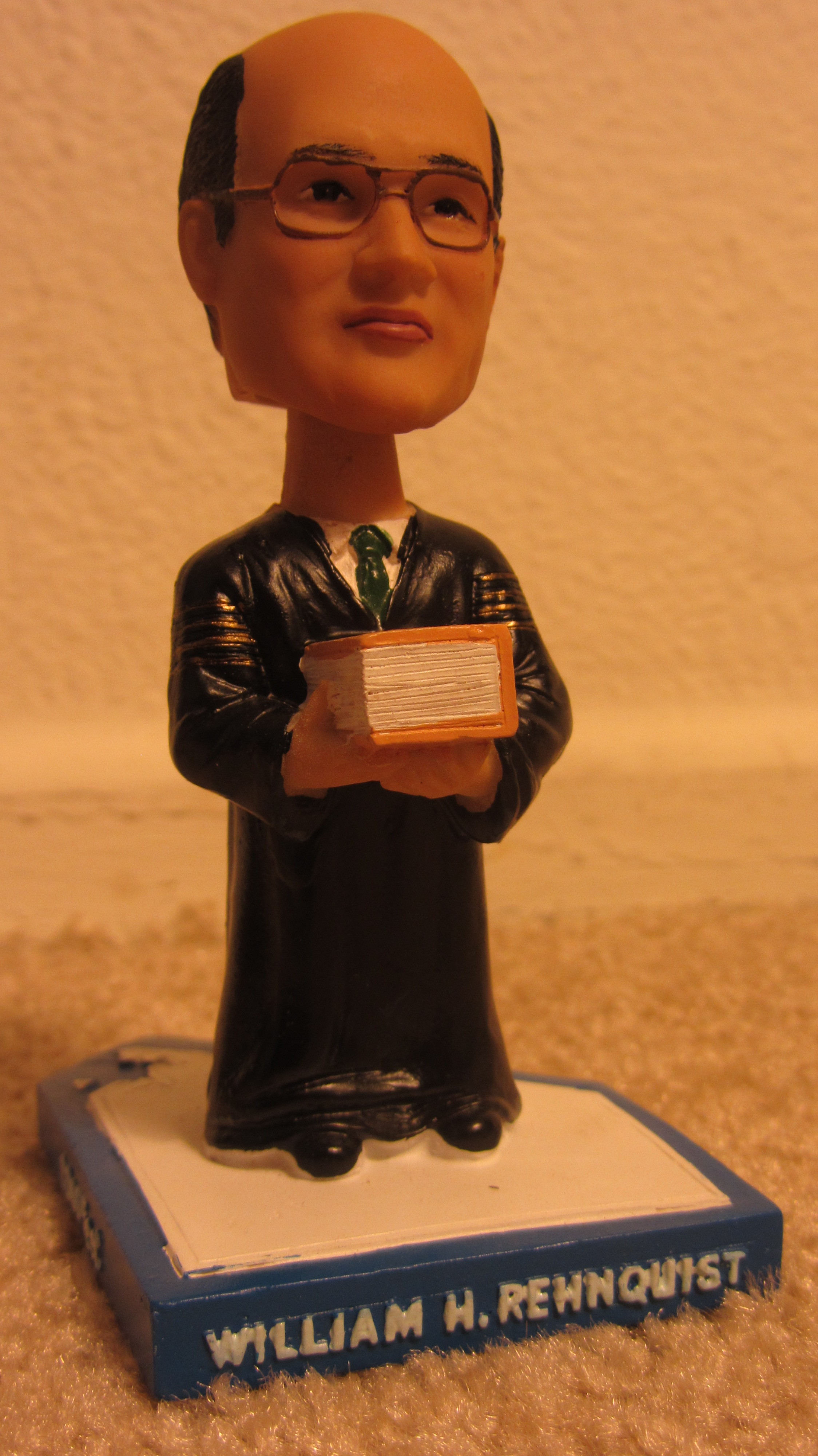
Chief Justice William Rehnquist, one of the other objects of the trip
The obvious prediction
Mildly-interested readers need know but two things to predict this case’s outcome. First, this case arose in the Ninth Circus Circuit: a court regularly with very outlier views. And not solely along the tired left-right axis: when the Court often summarily reverses the Ninth Circuit without even hearing argument, partisanship can play no role. Second, Sheehan must overcome qualified immunity, which for better and worse protects “all but the plainly incompetent” police against lawsuit. These facts typically guarantee San Francisco will win and Sheehan will lose.
That aside, one observation struck me. Stereotyping heavily, it’s surprising that San Francisco in particular would argue, to use overly-reductive descriptions, “for” police and “against” the disabled. Usually we’d assume San Francisco would stand by, not against, underprivileged minorities.
“Bait and switch”
That expectation makes this letter from advocacy groups requesting San Francisco abandon its appeal very interesting. At oral argument Justice Scalia interrupted San Francisco’s argument before it even started to bluntly charge the city with changing its argument, between its request for the Supreme Court to hear the case and when San Francisco presented its argument for why it should win — even calling it a “bait and switch”. Minutes later, Justice Sotomayor echoed his views (in more restrained terms).
When requesting Supreme Court review, San Francisco argued that the ADA “does not require accommodations for armed and violent suspects who are disabled” — during an arrest, all such suspects may be treated identically regardless of ability. In response the Court agreed to decide “whether Title II of the Americans with Disabilities Act requires law enforcement officers to provide accommodations to an armed, violent, and mentally ill suspect” while bringing him into custody.
But San Francisco’s written argument instead argued, “Sheehan was not entitled to receive accommodations in her arrest under Title II of the [ADA]” because her armed violence “posed a direct threat in the reasonable judgment of the officers”. In other words, San Francisco had changed from arguing no armed and violent, disabled suspect deserved an ADA accommodation, to arguing Sheehan particularly deserved no ADA accommodation because she appeared to be a direct threat.
Thus San Francisco’s argument derailed, on this and other points. Several minutes in Justice Kagan even prefaced a question with, “And while we are talking about questions that are not strictly speaking in the case,” to audience laughter. A Ninth-Circuit, plaintiff-friendly, appeal-by-the-government case is usually a strong bet for reversal, but San Francisco seems to have complicated its own case.
The Court could well dismiss this case as “improvidently granted”, preserving the lower court’s decision without creating precedent. Oral argument raised the possibility, but a month later it seems unlikely. San Francisco’s still likely to win, but the justices’ frustration with San Francisco’s alleged argument change might not bode well when San Francisco next wants the Court to hear a case.
Back to the letter
Again consider the letter urging San Francisco to abandon its appeal. Suppose the letter’s authors first privately requested San Francisco drop the case, resorting to open letter once those overtures failed.
But what if the letter wasn’t a complete failure? Could San Francisco have changed its argument to “split the baby”, protecting its officers and attempting to placate interest groups? The shift couldn’t have responded to just the letter, sent one day before San Francisco made its final argument. But it might have been triggered by prior behind-the-scenes negotiation.
This fanciful possibility requires that the open letter not be San Francisco’s first chance to hear its arguments. It further grants the letter’s authors extraordinary political power…yet too little to change San Francisco’s position. Occam’s Razor absolutely rejects this explanation. But if some involved interest group promptly tried to dissuade San Francisco, the letter might have been partially effective.
Final analysis
Are Justice Scalia’s and Sotomayor’s criticisms reasonable? I didn’t fully read the briefs, and I don’t know when it’s acceptable for a party to change its argument (except by settling the case). It appears to me that San Francisco changed its argument; my sense is doing so but claiming you didn’t is the wrong way to change one’s position. But I don’t know enough to be sure of either conclusion.
As I said yesterday, I didn’t fully prepare for this argument, so I hesitate to say too much. And frankly the messy facts make me glad I don’t have to choose a position. So I’ll leave my discussion at that.
This is part three of a series of posts discussing various aspects of a bike trip I did across the United States in 2012. Part one discussed the start of the trip and choosing a route. Part two discussed my daily routine and nightly shelter. This post discusses mileage, elevation, and the state-by-state scenery.
Mileage and elevation change
Excluding the first day, my daily mileage ranged from a low of 57.63mi to a high of 161.47mi. For the first “half” (psychologically) of the trip til Pueblo, I aimed to not lose ground from my overall target pace but didn’t sweat falling slightly short, and I averaged slightly under 100mi/day (even including that farce of a first day). Nevada’s emptiness strongly regimented my stops and pace. At one point I faced three ~70mi stretches between water, with further logistical challenges beyond: given my time constraints, I had to do two in a 135mi day, then the last plus a bit more the next day. But normally I biked shorter distances til the TransAmerica.
The end of the Western Express in Pueblo marked the start of the Great Plains, where I began to make up lost mileage. In Kansas I discovered 120-130mi was my maximum sustainable pace if I didn’t adjust my schedule to start earlier. Any further and the next day would be an invariably “short” 90-100mi. 120mi let me start somewhat later in the morning (I am absolutely not a morning person), eat reasonable lunches and dinners (if sometimes as gas station takeout), and read awhile before a decent night’s sleep. With more focus I might have started earlier and biked further. But I was on vacation, and I was, er, relaxing. If strict discipline wasn’t necessary, I wouldn’t force it.
That said, 120mi wasn’t always possible. The Missouri section had no difficult elevation, but it did have the Ozarks with an unrelenting sawtooth profile: not enough to exhaust, but enough to slow down the entire day. I eventually gave up on playing mileage catchup til Illinois and settled for not losing ground with ~100mi days.
Cedar City, UT to the red line is around 25mi: uphill but comfortably gradual
East of the Mississippi had arguably more difficult elevation than west. (Carson Pass might be an exception, as a very long ascent so close to the start.) Virginia’s section has more total elevation gain than any other state’s section. Eastern ascents were shorter but much steeper: nothing that couldn’t be handled shifting to lowest gear and spinning, but more exhausting. The steepest lengthy climb was around 4mi/2500ft to the Blue Ridge Parkway in Virginia. In contrast the climb to the Continental Divide was 10.5mi/2800ft.
Scenery and attractions
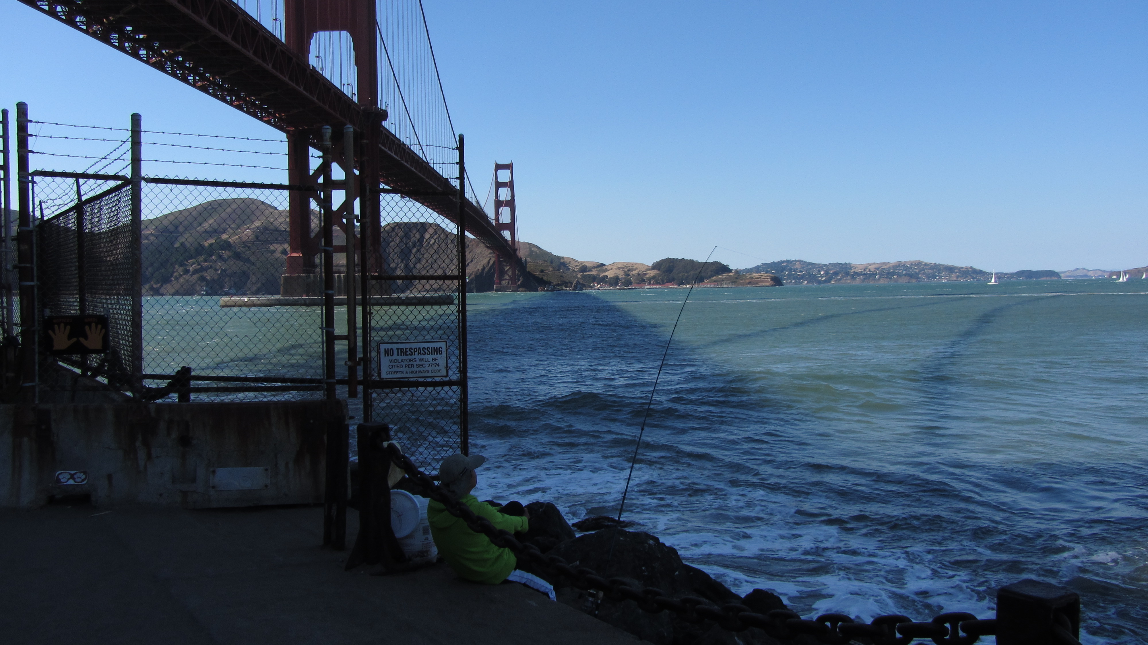
The Golden Gate Bridge, and the start of my trip
California was the least interesting of the western states. The first hundred miles from San Francisco were mostly flat and unvarying: not bad at the start, but still not interesting. The gradual multi-day climb to Carson Pass had its attractions, particularly along California’s SR 88. But California was a short and mostly undistinguished state to bike through, at least along this route.
Of the western states, Nevada was the most majestically desolate. Pass through a basin (carefully winding between mountains), climb to a pass, descend to a basin, and repeat through the entire state. All around were mountains and emptiness; it was the state where I felt most truly alone. (Which as an introvert I consider not a bad thing.) The climbs were never particularly steep, and the descents never astonishingly so, yet I hit ~40mph most days through it. Strangely, of all the states I passed through, I think Nevada is the one I’d most want to return to on bike, even tho it has “nothing” to recommend it.
Nevada’s scenery doesn’t change very quickly, but it’s all beautiful like this
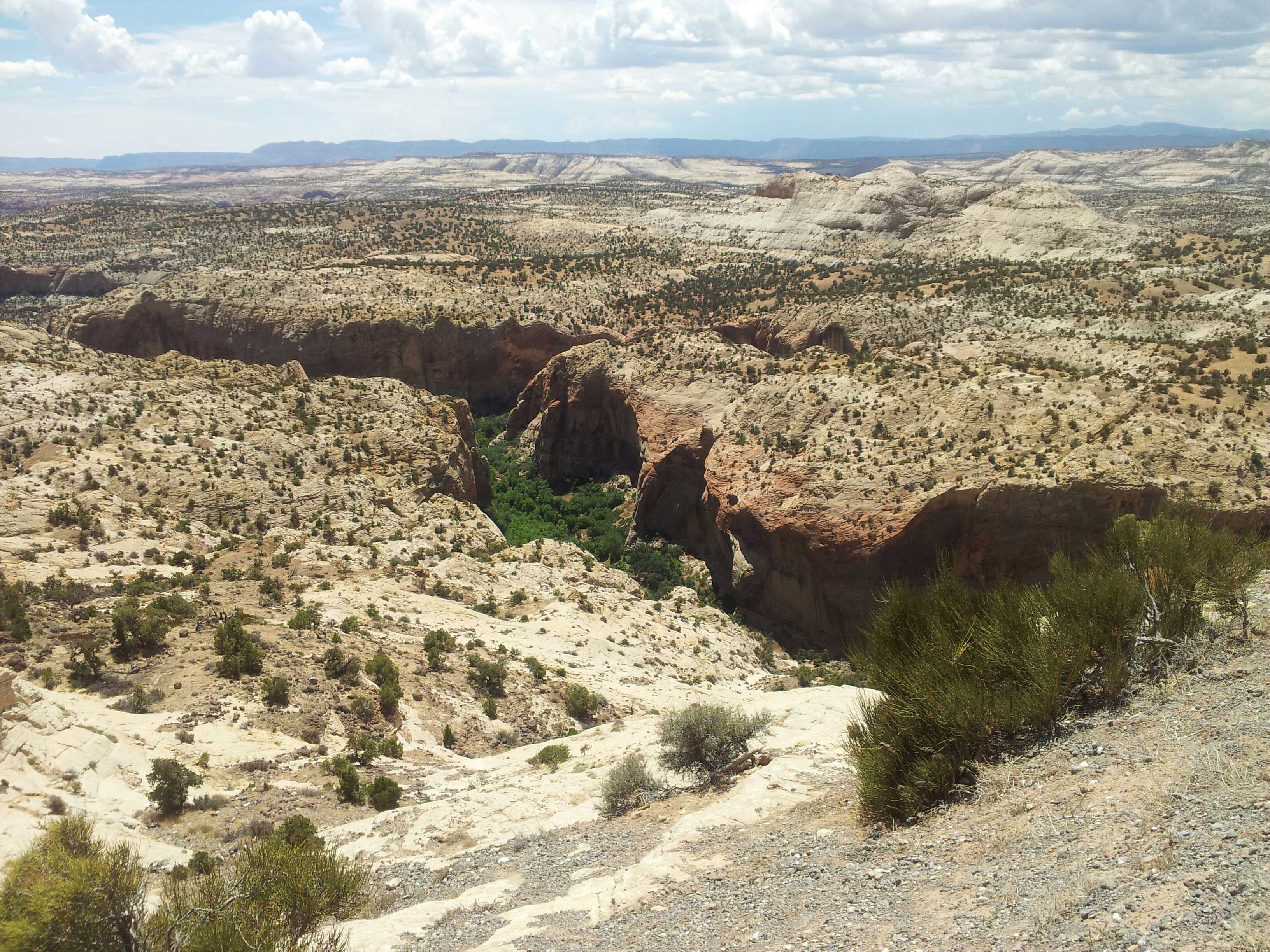
Utah and the mountainous portions of Colorado were much more varied: good in their own ways, yet not in Nevada’s unique way. After that initial 84mi waterless stretch (from just in Nevada to well into Utah), I encountered irrigated farmland, red sandstone rock formations, and a good variety of desert vegetation. The empty stretches didn’t have the consistency of terrain that Nevada’s did. I did pass through emptiness, but that emptiness carved across mountainsides, descended into and out of valleys, and passed through several national parks with incredible scenery. Nevada’s uniqueness aside, Utah and Colorado were the best states of the trip.
A sampling of Utah’s varied vegetation and scenery
West of Pueblo turned into the Great Plains: the tail end of Colorado, and Kansas. The riding is basically flat, with mercurially-shifting prairie winds kicking in to keep things interesting. Even crosswinds that aren’t actually impeding you can really sap energy. The Colorado portion wasn’t particularly different from the Kansas portion, except that the local towns along CO-96 banded together to create the Prairie Horizons Trail — a naming and sprucing up of the stretch to particularly accommodate touring cyclists, complete with map listing services at locations along the way. It was definitely a nice touch. 🙂 Kansas was much the same, excepting that the route traveled many different roads, slowly cutting south as it crossed the state. Both routes were notable for their sheer emptiness: not in the desolate manner of Nevada, but in the way that, leaving one town, you could see the grain elevator in the next town, and the utter lack of anything but fields of grain before it.
Sunset colors in Kansas as nighttime riding beckons
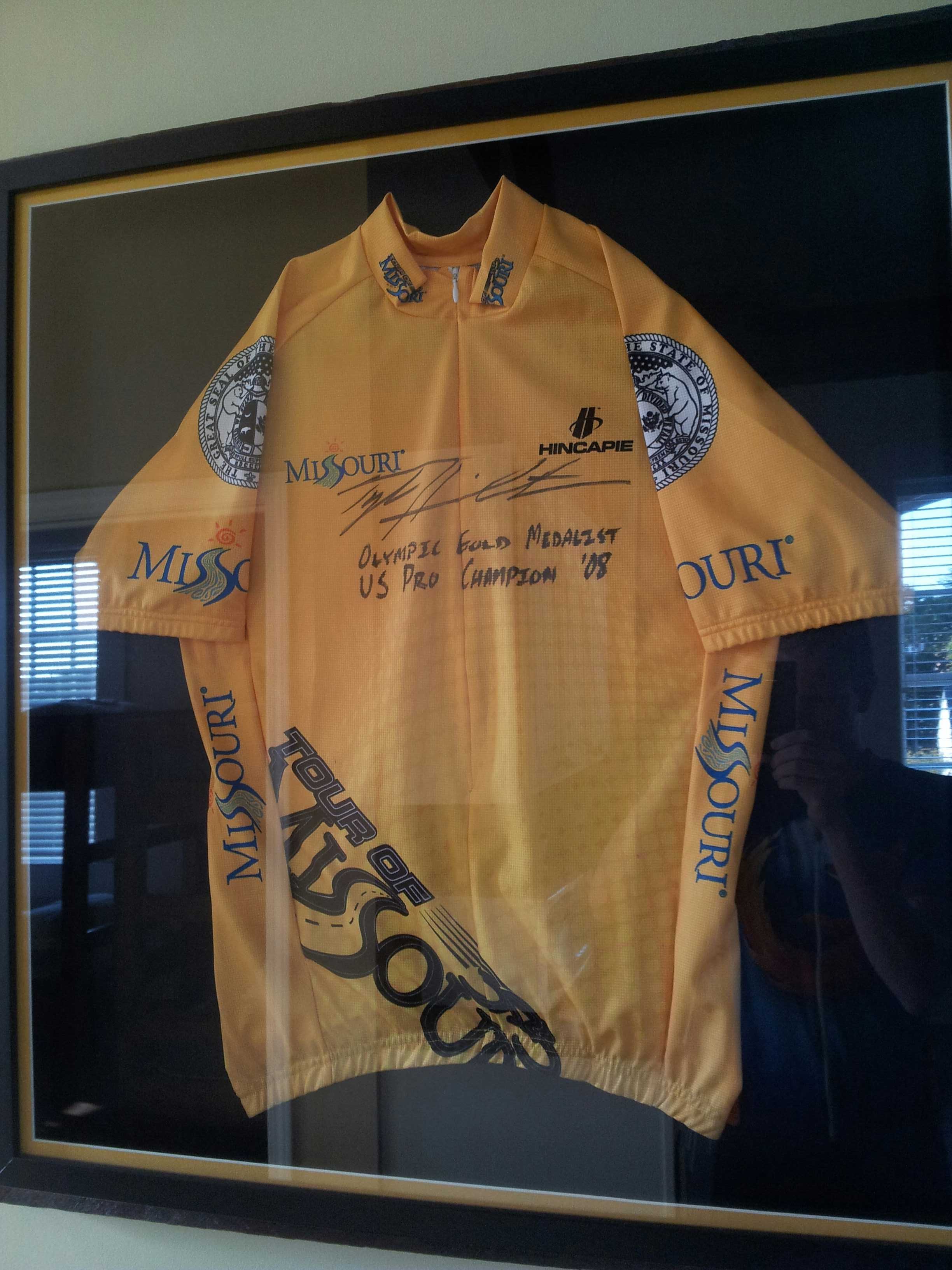
Missouri was my least favorite state for two reasons. I’ve already mentioned its sawtooth climbs and descents. The second reason is that Missouri was one of only two states where I was ever aggressively chased by dogs. This was not a rare occurrence: it happened multiple times, including a couple times in complete darkness. Fortunately, I was able to bike just fast enough that dogs that appeared to have every intention of attacking me could only just keep pace with me til I left their home ranges. I evaded them all, but always with a fast-pounding heart afterward. Missouri did have Al’s Place, the nicest hostel of the entire trip — a former (converted) jail run as a hostel for cross-country cyclists.
A jersey that, er, “graces” Al’s Place; my timing seeing it on August 12 was impeccable
Illinois was a short and sweet state I passed through in about a day, near the southern tip. It had the Mississippi and Ohio rivers at start and end to recommend it, but it was mostly uneventful. It played host to the worst rainstorm of the trip, which passed over me during a brief gas station stop. I delayed leaving an extra fifteen minutes to avoid biking in briefly-torrential rain; it would have been impossible to see through it while riding. Its other attraction was the milk shake at Rose Kountry Kitchen in Cave-In-Rock. I ordered it sight unseen before looking at a menu. When I looked at the menu I discovered there were two sizes; I quickly upgraded my request to the 32-ounce (!) size, to much astonishment from the restaurant staff. There’s nothing better than that many calories, as ice cream, while biking.
The ferry across the Ohio was one of my more unique moments of travel
Kentucky, sad to say, was at times the grungiest state of the trip. The graffiti on the state welcome sign just past the Ohio didn’t bode well. And the many run-down homes and trailer homes on the many back roads on which I traveled only confirmed this. And Kentucky’s dogs were probably the worst of the entire trip. TransAm cyclists told me of other cyclists who’d had to get stitches from dog bites suffered in Kentucky. I evaded any bites, but as in Missouri, it was very stressful doing so. The best part of Kentucky, however, was the Utica Fire Department, which lets cyclists stay in the volunteer fire station overnight; I particularly appreciated it after a ~142mi day. I just wish I’d been able to say hi to more firefighters while I was there.
Welcome to Kentucky 😐
Virginia presented the Appalachians, the Atlantic, and the end of the trip. Virginia’s route paralleled the Appalachian Trail for awhile, giving me the opportunity to briefly revisit many places I’d visited four years before. I stopped early in Damascus, partly from tiredness, partly to stay at The Place, a hostel I’d visited while hiking the A.T., partly for a good dinner, and partly to make an early start on the mother of all days the next day. (More on that later.) My mileage worked out just right so that my last day was a pleasurable hundred miles into Yorktown — made slightly hectic by two broken rear spokes with 25mi remaining, yet leaving me several hours in the evening for a good dinner, ice cream, and a beer. Grace Episcopal Church hosted me as a cyclist on this last night, giving me an opportunity to wash laundry and clean myself up before heading to Norfolk to fly back to California the next day. (Yes, this cut it close, but I was fairly sure it was always going to be that way.)
One year ago, after 37 days of biking around ~3875mi total starting in San Francisco, I reached Yorktown, VA to finish biking across the country. An exact day-to-day accounting would likely bog down in uninteresting logistics (particularly given the way I traveled — other approaches would likely yield more interesting day-by-day commentary). Instead, I’m going to cover a variety of topics of interest from the trip, in somewhat random order, in series. If you want a very cursory, sometimes out-of-order account of the trip, reading approximately July 18 to August 25 of my Twitter stream covers it.
The secret to my speed: obviously the cycling jersey
An inauspicious start
The trip got off to a bumpy start the Tuesday night before I planned to leave. I planned to ride my spiffy, super-light carbon-fiber racing bike. I use it for regular transport, so I waited to get a final tune-up til the last minute, picking it up the evening before I departed. I began loading it with panniers and gear. Racing bikes don’t have mounts for carrying gear, so I’d use a seatpost rack (with correspondingly light ~16-pound load). When I began attaching the rack, I noticed the clamp matched a much smaller-diameter seatpost. Looking at how the clamp would make contact with the seatpost, it suddenly occurred to me that attaching a seatpost rack to a carbon fiber seatpost might not be a good idea. Carbon fiber is strong along its length, not laterally: the clamp could easily crush the seatpost.
Shiny! But really not the thing to use for touring
Wednesday morning, I asked the bike shop if they had an aluminum seatpost of the right size. They wouldn’t have one til Friday. Other local shops didn’t have any, either. Replacing the seatpost was out.
Seeing no other options…I went to the first bike shop, bought a non-carbon road bike that fit me, walked home with it, transferred gear and pedals to it, and biked to Caltrain to head to San Francisco to start the trip.
Thus I crossed the country on a bike I bought the day I left.
Too bad that mental health center wasn’t closer to the start of the trip, there might have been hope for me then
This is crazy. But not quite as crazy as it sounds. I’d purchased a 2012 Scattante R-570; I’d previously owned the 2010 version, so I knew I’d be comfortable. And months before, I’d considered getting a touring-oriented bike for extra carrying capacity. But I’ve never spent money very easily. I had the money, but I didn’t want to spend it if I didn’t have to.
Now I was in a “have to” situation. Riding a totally untested bike would rightly scare most people to death. Most people would probably cancel the trip or substantially change plans. But my philosophy is that what must be done, can be done. So I did it.
Other than lost biking time (day 1 was 23.76mi route miles rather than the ~100mi I’d intended — no small loss, but not huge, either), all I lost was the ability to buy the bike on sale for ~$160 less. It could have been worse.
Choosing a route
I traveled pretty much entirely with the aid of the Adventure Cycling Association‘s route maps. I considered finding my own route, but I discarded the idea for lack of time and being unsure I’d enjoy route-planning. In hindsight this was clearly the right choice. Unless you enjoy route-planning for its own sake, buy existing cycling maps. You’ll get better routes, and more cycling-useful information, than you can create on the fly. (Plus GPS units cost hundreds of dollars and must be charged every night.)
A profile from an ACA map, that’s likely harder to find outside of prepared maps
The 4200-mile TransAmerica Trail goes from Oregon into Montana, southeast to Pueblo in Colorado, then east to Virginia and the coast. It’s the most well-known and commonly-used cross-country route. The 1580-mile Western Express goes from San Francisco to Pueblo. Most people do the TransAmerica because it avoids much waterless desert and elevation change. For me, convenience and available time made the Western Express and eastern TransAmerica a no-brainer.
A definite perk to using an existing route is that the roads will be good for cycling. Often I was on relatively empty back roads, or on state roads with light traffic. The worst roads were in the Rockies in Colorado, likely because of the terrain. The worst regularly-bad road occurred between Cimarron and Sapinero along US-50: a narrow, winding stretch of road with little shoulder and a bunch of RV traffic, where I should have occasionally taken the entire lane rather than let anyone unsafely pass me. Colorado also had the worst irregularly-bad stretches of road, along CO-145 due to road construction. There were two two-mile stretches of riding through gravel where roads were being re-oiled, which I rode through (what choice did I have?) past Motorcycles use extreme caution signs on 700×23 tires (less than an inch wide). Good times. And the stretch from Telluride to Placerville had so much construction dust I sometimes couldn’t see ten feet; I had to stop and turn on head and tail lights to be visible. But generally, ignoring these rare exceptions, the roads were great.
I tend to take verylongvacations. Coding gives me the flexibility to work from anywhere, so when I travel, I keep working by default and take days off when something special arises. Thus I usually take vacation in very short increments, but very occasionally I’ll be gone awhile. And when I’m gone awhile, I’m gone: no hacking, no work, just focused on the instant.
My last serious-length vacation was August-September last year. And since then, I’ve taken only a day and a half of vacation (although I’ve shifted a few more days or fractions thereof to evenings or weekends). It’s time for a truly long vacation.
Yeah, I’m pretty much using it all up.
For several years I’ve had a list of long trips I’ve decided I will take: the Appalachian Trail, the John Muir Trail, the Coast to Coast Walk in England, and the Pacific Crest Trail. I’ve done the first two in 2008 and 2010 and the third last year. The fourth requires more than just a vacation, so I haven’t gotten to it yet. This leaves one last big trip: biking across the United States.
Tomorrow I take a much-needed break to recharge and recuperate (in a manner of speaking) by biking from the Pacific to the Atlantic. (Ironically, the first leg out of San Francisco is a ferry to Vallejo.) I have a commitment at the back end August 25 in San Francisco, and a less-critical one (more biking, believe it or not!) August 26. The 24th must be a day to fly back, so I have 37 days to bike the ~3784 miles of the Western Express Route (San Francisco, CA to Pueblo, CO) and part of the TransAmerica Trail (Pueblo to Yorktown, VA). This is an aggressive pace, to put it mildly; but I’ve biked enough hundred-mile days before, singly and seriatim, that I believe it’s doable with effort and focus.
Unlike in past trips, I won’t be incommunicado this time. I’ll pass through towns regularly, so I’ll have consistent ability to access the Internet. And I died a little, but I bought two months of cell/data service to cover the trip. So it goes. I won’t be regularly checking email (or bugmail, or doing reviews). But I’ll try to make a quick post from time to time with a picture and a few words.
I could say a little about gear — my twenty-five pound carrying capacity in panniers on a seatpost-mounted rack, the Kindle I purchased for reading end-of-day (which I’ve enjoyed considerably for the last week…as has my credit card), the 25-ounce sleeping bag I’ll carry, the tent I’ll use. I could also say a little about the hazards — the western isolation (you Europeans have no idea what that means), the western desert (one Utah day will be 50 miles without water, then 74 miles without water), the high summer climate, the other traffic, and simple exhaustion. But none of that’s important compared to the fact that 1) this is finally happening, and 2) it starts tomorrow.
“And now I think I am quite ready to go on another journey.” Let’s do this.


